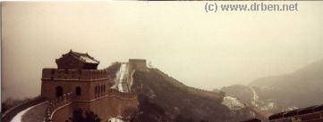
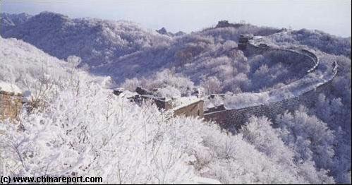
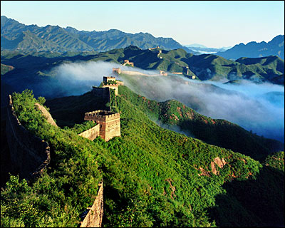
First built during the Qin Dynasty 550 AD - 557 AD), the Mutianyu Great Wall was rebuilt during the Ming Dynasty Era to consolidate this important and strategic Pass giving direct access to the Imperial Capital at Beijing. 1.4 Miles of GreatWall and Watchtowers can be visited.
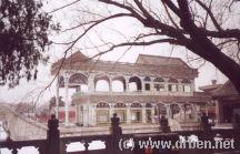
A wintery and snowy introduction to the magnificient Summer Palace museum at the North-
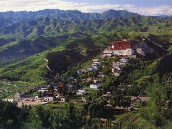
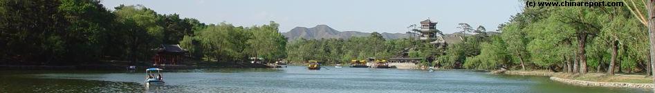
Just 4 hours travel from Beijing, the Imperial Summer Mountain Retreat at Chengde. The whole small City is occupied by the fleeing the Heat Mountain Villa and its surrounding Gardens and Temples, last remnants from the Last Blossomings of Imperial (Qing) Dynastic China. Don't miss out on this Jewel of a Destination!
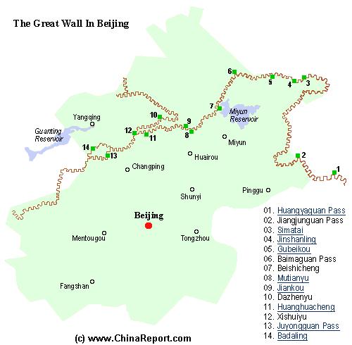
There are many places where the Great Wall of China can be visited near Beijing. Apart from the most well-known spots which lie in Beijing City Province (Municipality), there is a multitude of lesser or smaller sites dotted throughout Hebei Province between Qinhuangdao at the coastline in the East all the way to the Shanxi-Hebei Provincial Border, West of Zhangjiakou (Kalgan). In fact, beyond in Shanxi Province there are another set of Great Wall passes and remnants of both Outer Layer and Inner Defensive Layers, among which some quite famous locations. Those Great Wall of China sections will however, not be discussed here.
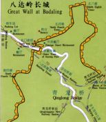
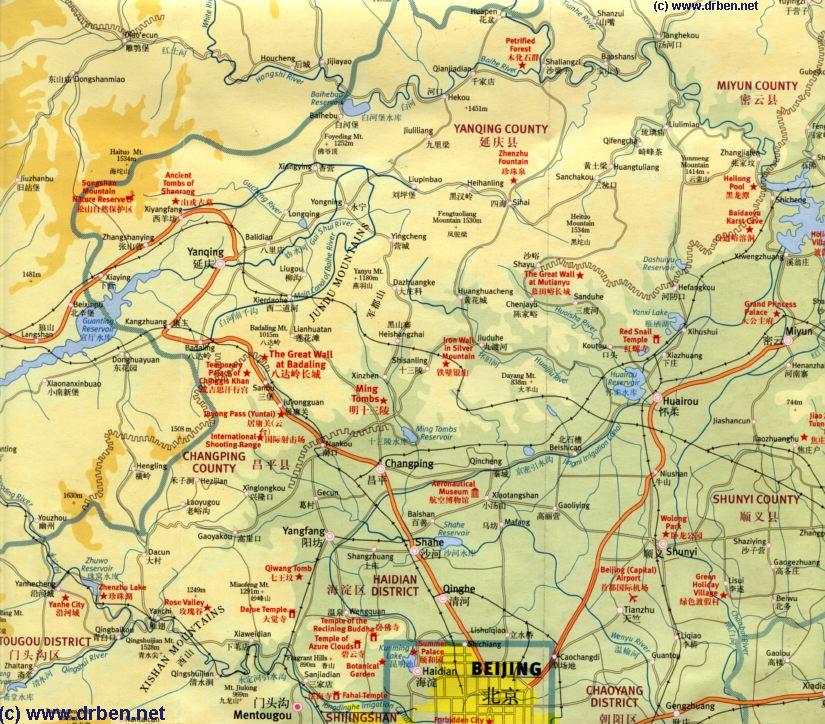
Link: Satellite Image with Schematic of the Location and path of the Great Wall of China during the Ming Dynasty. Visitable Locations & Passes on the Great Wall included.
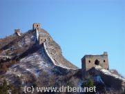
Great Wall at Badaling in Winter
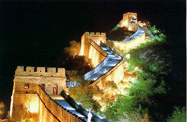
A foggy but quite unique introduction to The Great Wall of China at its point nearest Beijing. Badaling is the place President Nixon visited on his historic visit and the most popular Great Wall tourist destination of Beijing City after the Palace Museum or Forbidden City.
Built in a mountainpass giving access to the North China plain the Badaling Great Wall section gives the visitor a fairly good example of the what the Great Wall was built for and how challenging its defensive works were.
Enjoy our introduction of this restored wall section.
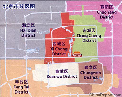
Outside of Beijing City lies the City Province (Municipality) of Beijing, where there are even more worthwhile monumental, historical and scenic sites to visit and enjoy.
Starting with an Introduction and Overview of the Cities' Province and its facts and figures, this text Reviews the highlights and Main Scenic Sights to be visited and Ends with a brief explanation the issue of (Public) Transportation in and around The Province. From those Monuments located nearest Beijing and those most well-known, to the remote and more obscure this pages gives a short but thorough introduction to Beijing City Province and its historic Monuments.
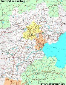
Covering a surface area of 16 Thousand 800 Square Kilometers (6.487 sq. Miles) Beijing Municipality is one of China's 4 large City Provinces. To the South-East lies Tianjin Municipality and all other surrounding area's are taken up by Hebei Province.
Today Beijing Municipality counts some 15 Million + inhabitants, spread over 16 Districts and 2 Townships. For proper understanding and easy navigation and travel throughout the Province however, it is easier to see things in a slightly simplified perspective.
In the recent past Beijing Municipality was difficult to reach for Foreign Travelers unable to speak and read Chinese and/or manage the intimidating Train Schedules and Bus Lines that lead into the Province. For all practical purposes, hardly anyone traveled there except by well organized guided tour and bus ride. The only alternatives for traveling into the Province where the train to Badaling to be taken from Xizhimen Station in the Haidian District and the Long Range Bus Lines traveling to Yiheyuan - Summer Palace and then onwards to Badaling Great Wall and the 13 Ming Toms (Shi San Ling). Of course those with enough finance could arrange to rent a Private Cab (Taxi) for a day or rent a car en go anywhere wished for.
Today this is no longer the case. Starting with the advent of modernity in Beijing in the years between 2000 and 2002 AD, followed by rapidly by a massive economic boom and the development of the City as the host for the 2008 AD Olympic
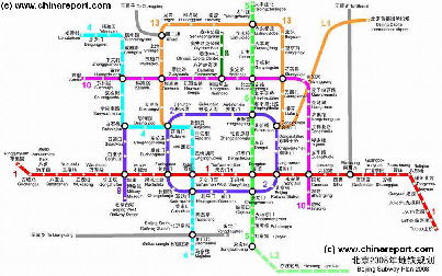
Full Map of the Beijing Subway System of 2008 AD - Click Map for FULL Version !
Within Beijing City Province there are almost too many historic places to visit and enjoy. Not to mention the considerable facilities for pure entertainment and leisure, ranging from the Beijing Golf Club and the Badaling Wild Animal Park to recent additions installed for the 2008 AD Olympic Games in Beijing
The first Layer consists of the Inner Suburbs of Beijing, some of who's Monuments used to demand quite some traveling time and in practice lay at quite some traveling distance from the Ancient Walls of the Ming and Ching Dynasty Capital, and the Central City Center within the 2nd ring road.
Although until at least 2002 AD, the Northern Parts of Haidian District including both Summer Palace locations were in practice part of the Province rather than the City, in recent years this situation has been dramatically changed by the advent of modernity in Beijing
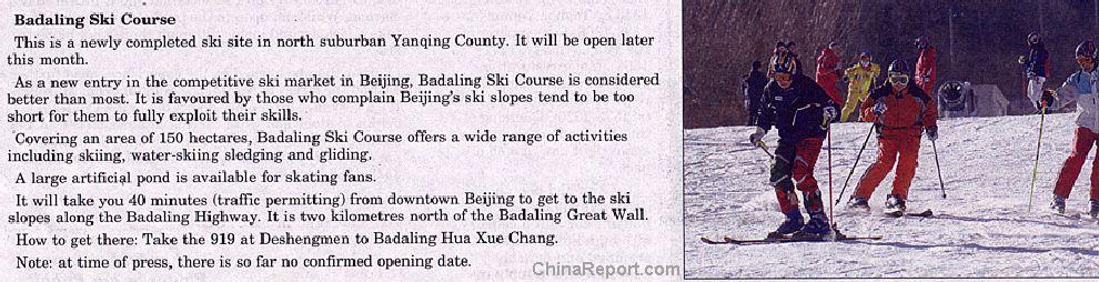
Starting in the North-West, Yanqing County is the home of the most famous and most visited section of the Great Wall of China in Beijing City Province, the Badaling Great Wall of China. Apart from this, it is further home to some lesser known but interesting historic relics such as the The Guyaju Ruins, ancient Cave dwellings and the northern coastline of the Gargantuan Guanting Lake Fresh Water Reservoir.
Although extremely few foreign visitors dwell far beyond the Great Wall and nearby villages, upon your encounters with locals you may note a high frequency of people having yellow teeth. A peculiar localized phenomenon, the peoples yellow teeth are caused by a longstanding problem with the high fluor content of the local drinking water. For long the people, mainly from North-West Yanqing county have suffered from a negative reputation in neighboring area's, suffer from dental problems and even brittle bones. They often feel inferior. Some villages are relatively weary of outsiders.
Especially hit has been the village of Hujiaying, with only a few households. Regardless of various efforts, the local Government has been unable to locate a clean water source within miles of the village, and so clean water would have to be channeled in from the outside. The cost of such a project have proven too high so far, leaving the village with unfit drinking water and no alternatives in sight.
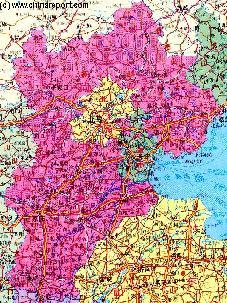
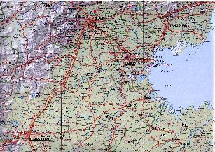
Hebei Province Map 2 - Geographic Map
A Geographic Map overview of North-East China's Hebei Province entire, delineating Hebei Provincial Borders, Beijing City Province, Tianjin City Province and parts of neighboring Shanxi-, LiaoNing- and Shandong Provinces and Inner Mongolia AR. Map includes Great Wall of China Locations in Hebei Province, Main Cities and Towns (shown by size), Hebei Province Monuments, Main Mountains (with Height), major highways, railroads, waterways, and Airports (National & International) and links to furher information.
An Introduction and historic backgrounds to each Beijing City District with Menus accessing each Landmark, Monument or Hot-spot Photo-Report, Maps and Sources.
Airport Expressway
2nd Ring Road
3Rd Ring Road
4Th Ring Road
and an explosion in infra-structure spending. Blessed with the new Beijing City Public Transportation System as well as a remarkably expanded highway and road network the first three of these districts (Chaoyang,Haidian and Fengtai) are now well integrated and to be considered part of the City rather than the Province.
The Six Outer Suburbs are equally described in their own seperate section and chapter.
Western outskirts of Beijing City.
Take a photographic tour with novice level Historic explanation of this important Cultural Relic that was home to the Imperial Throne of the later Ching Dynasty (after the Burning of The Old Palace in 1890) and the place from where the most hated and notorious woman in China's history , Empress-Dowager Hsu Tsi ,wielded her Powers.
Webstyle produced NavBar
Miyun District (until fairly recently County) is well-known among those who visited earlier as the Home of the large Miyun Reservoir, beyond of which lie the Great Wall of China at Gubeikou, Jinshanling and Simatai. Miyun is therefor a well-visited County of the Province.
Bordering on the East of Yanqing County lies the Huairou District.
Due to its rural caracter, Huairou was a County until the year 2001 AD. However, with a rise in population as well as the addition of new train and highway connections, the Hairou County has been promoted to be a District of the City Province. The Newly established District covers a surface area of 2,557.3 Square Kilometers, counts 7 towns and 14 Townships and has a population of some 300.000 souls. Some 69% of the Huairou District is forested territory, making it valuable as the "Green Lungs of Beijing".
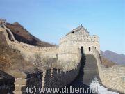
Huairou District is the home of the Mutianyu Section of the Great Wall of China as well as the popular Hujing Water Park Resort.
Games, Beijing has transformed itself into a thoroughly modern City with an extended public transportation system and quality facilities for Foreign Travelers. All road signs, train- and subway schedules are available in English Language and other such minimum necessities for comfortable travel have been installed. Direct Trains now connect to the Capital International Airport, Subway Lines arch the City and connect to outlying districts and a newly constructed highway system makes travel throughout easy.