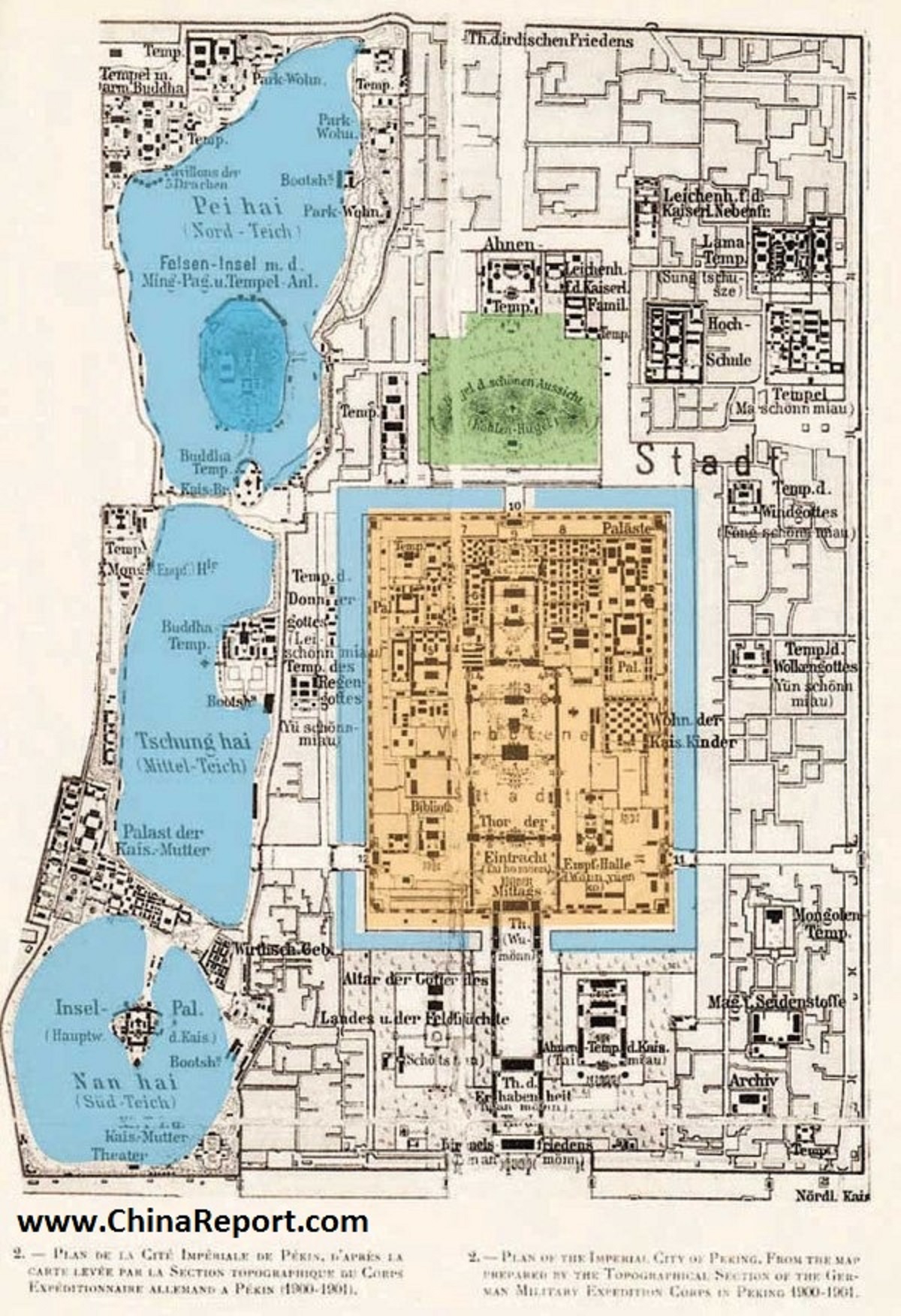
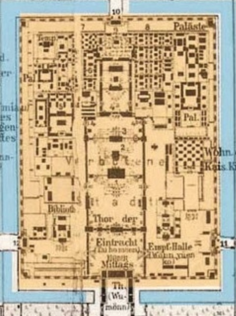
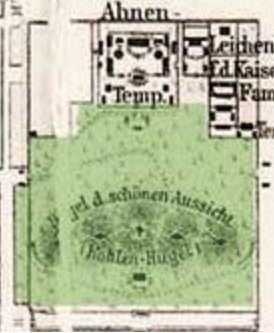
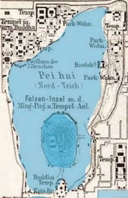
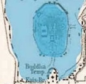
This Historic Map of the year 1900 AD provides a clear overview of the so called Imperial City of Beijing, which is the area of the extended Imperial Palace with at its center the core Palace of the Emperor, the so called Forbidden City.
The Imperial City was a restricted and protected zone which covered large portions of today's Xicheng and Dongcheng Districts and included as is shown on the map; North Lake (Park), Jingshan (Coal Hill) Park, the current day Palace Museum (Forbidden City) as well as the South and Middle Lake complex (Zhongnanhai for short). Today the former Imperial City has been dissolved and fragmented but it is still recognizable by its Red chalked surrounding walls. All of its Gates have disappeared since. Its various parts are now mostly open to visitors as public parks, however not so with the entire Zhongnanhai Complex which ranks among the most secure zones within the city of Beijing.
Created by the engineering corps of the invading German Forces during the so called Boxer War (1900 - 1904 AD) this general map meticulously includes the location, size and lay out of most structures, palaces, towers and pavilions, streets, walls, moats and gates within especially select and elite Imperial City District of the Time.

Browse the Map and Click through to additional Maps highlighting each partial area within the former Imperial City Area. For backgrounds and photo's, click red buttons and go through.
Beijing Imperial City 1900 AD Schematic Map 01 including Zhongnanhai Complex
To Summer Palace Introduction
Gate of New China (Xinhua Men)
Go to www.drben.net webring
To Main Menu of All Websites at DrBen.Net
ChinaReport.com at
Dragon King Temple
Sattelite Image Map of Zhongnanhai
All Maps Menu by The Beijing Reporter
Temple 1st
<- Mongol Emperor
This page was last updated on: June 6, 2017
My Great Web page
Beijing Landmarks
Beijing Introduction
Beijing Online Sources
Beijing
Beijing Home
Beijing Hotels
Beijing Maps - Index
Beijing Public Transport
City Province Transport
Beijing by District(s)
Chongwen
ChaoYang
Dongcheng
Fengtai
Haidian
XiCheng
Xuanwu
6 Outer Suburbs
TiananMen Square
Alphabetical Order
By Function(s)
Forbidden City
Hebei Province
Hebei Province Home
China Offline Sources
AsiaReport.com Home
China Report Home
China Online Sources
China Online Store
China Maps
China
China Photo Galleries
China Report Club
4 Rural Districts
Shijingshan
Maps of Chaoyang
Maps of Chongwen
Maps of Dongcheng
Maps of Fengtai
Maps of Xicheng
Maps of Xuanwu
Maps of Haidian
Maps of Shijingshan
Beijing Great Wall Maps
Beijing North China Maps
Historic Maps of Beijing
BJ Public Transport Maps
Click through to Map of the Palace Museum (Forbidden City) !
Dong An Gate Market
Palace Museum - West Flowery Gate (Xihua Men)
Click through to Map of Jingshan (Park) !
Click through to FULL Map of Beihai (Park) !
Moat
Click through to Satellite Image Map o/t Southern parts of Beihai (Park) ! - Round City and Jade Islet.
North Lake Park (Beihai Gongyuan) - South Main Gate
North Lake Park (Beihai Gongyuan) - Circular City
North Lake Park (Beihai Gongyuan) - South West Gate
Moat
Chongzhen Emperor o/t Ming Dynasty - Hanging Tree & Monument
Shou Huang Hall - former Imperial Temple of the Emperors o/t Past.
RESTRICTED - Ministry..
Imperial Library Vault (Imperial Archives) - Current main gate (west minor gate).
Imperial Library Vault (Imperial Archives) -(CLOSED - South main gate).
Temple today known as Pu Du Si..
Dong An Gate - Today: excavated ruins of..
Rostrum of Tian An Men Gate (Gate of Heavenly Peace Platform).
Tian An Men Gate (Gate of Heavenly Peace Proper).
Palace Museum - East Flowery Gate (Donghua Men)
Archery Field
Moat
Moat
Dong An Street
ShenwuMen - North Gate of Divine Might
Wumen - Gate o/t Meridian (Five Phoenix Tower)
Palace of Imperial Peace (in Imperial Palace Garden (Yuhuan Yuan))