This page was last updated on: July 22, 2017
N312 Shanlin Expresway or Lanzhou-Urumqi Highway: To Shandan & Wuwei
Go to www.drben.net webring
National Road 312 Shanlin
<-- Expressway
Hexi College
X
Ganquan
Park
<--
Double Pagoda
X
Hei He (Black River)
X
Hongyu
Business &
Trade Square
  X
The below Satellite Image gives a rough overview of the "City" Of Zhangye (Ganzhou) in the Hexi Corridor of West Gansu Province, China.
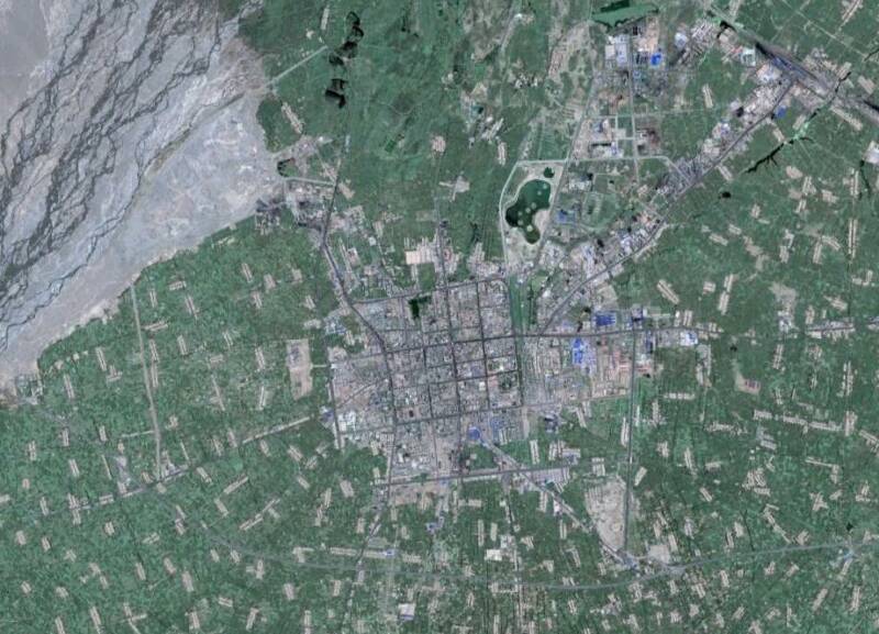
Looking clockwise around the main features of this Satellite Image based map are: In the East and North-East, the flow trajectory of the Hei He or Black River. The Hei River is the main river in this section of the mountainous Hexi Corridor and is the main source of water and the green abundance of Zhangye. In the North-East lies the Zhangye Railway Station, one of many along the Lanzhou-Urumqi Railway.
Zhangye is surrounded by irrigated lands, which are mostly used for agriculture. Provincial Road G.312 leads from East to West through the Image. Eastward it travels to Shandan. The main highway and thoroughfare of the City and Region is the Shanlin Expressway, designated as National Road 312. The Shanlin Expressway, or Lanzhou-Urumqi Highway is a well-kept modern highway which leads past the City of Zhangye someway's South of it. Note: this Highway is not to be confused with G312 Provincial Road. Which comes into the City from Shandan in the East, but leaves the City through its North-west corner.

Find the modest City Urban Area in the center of the City and view the general lay-out, square shaped and including roads which lead in a North-South or West to East direction.
For easy navigation, the Drum Tower stands at the Center of the Old City. From there, most City landmarks & monuments are within walking distance. Only the Double Pagoda and the Gao Miao Temple require a Taxi or Bus Drive.
Hotels are centered around the Drum Tower and main East-West Boulevard. More can be found along the Road between the Old Town center and the Main Train Station.
For the convenience of Tourists and locals alike, there are at least 4 supermarkets in the City and a Shopping Mall.
The Zhangye Report
Introduction to Zhangye Satellite Map
Go to www.drben.net webring
To Main Menu of All Websites at DrBen.Net
ChinaReport.com at
MuTa
Minqin Hall
No. 312
<-- Prov.Road
No.G312 Prov.Road
- East to Shandan
Drum Tower
X
Christian Church
Dafo Si - Temple of Reclining Buddha
Dafo Si
X
Nongji
Shopping
Center
X
3 Super-
markets
Zhangye
Train
Station
<--
<-- No. G312 Prov.Road
- to Linze & Gaotai
<-- No. G312 Prov.Road
- to Linze & Gaotai
X
Gao miao Temple
Wu Dui
Youtian Hotel
Fengtai
Supermarket
<--
X Qiche East
Bus Station
Ganzhou Market
<--
- Compare Satellite Image of Zhangye to Google Satellite Map below -

View AsiaReport.com - Mastermap of Asia (entire). in a larger map
To Previous Page - Zhangye Map Index
This page was last updated on: July 22, 2017
My Great Web page
Zhangye History
Zhangye Landmarks
Zhangye
Gansu Sources
Gansu Province
Baiyin Home
Gansu Province Home
China Offline Sources
AsiaReport.com Home
China Report Home
China Online Sources
China Online Store
China Maps
China
China Photo Galleries
China Report Club
Wuwei
Wuwei Home
Baiyin Prefecture
Zhangye Home
Tianshui
Tianshui Home
JiaYuGuan
JiaYuGuan Home
JiuQuan Prefecture
Aksay AC Home
Dunhuang City Home
JiuQuan Home
Dingxi Home
Dingxi Prefecture
Gannan Home
Gannan Prefecture
Lanzhou
Lanzhou Home
Huixian Home
Longnan Prefecture
Pingliang
Pingliang Home
Linxia (Hui) Prf.
Linxia Home
Qingyang
Qingyang Home
Jinchang
Jinchang Home
Gansu Economy
Gansu History
Gansu Monuments
Gansu Maps
Gansu Minorities
Yellow River in Gansu
Zhangye Maps
Zhangye Minorities
City Landmarks
Counties + Landmarks
Minle County
Zhangye Sources:
Linze County
Gaotai County
Shandan County
Sunan Yugur County