To The China Report Main Menu
This page was last updated on: July 22, 2017
The Zhangye Report
Go to www.drben.net webring
To Main Menu of All Websites at DrBen.Net
ChinaReport.com at
History of Zhangye and City Prefecture
Shandan
Sunan
Shandan Army (PLA) Horse Farm
Shandan
Dahong Shan (Height: 1924 meters)
Mati Si - Buddhist Caves - UNESCO World Cultural Heritage Site
Qin Ling Mts
Hui
Sanguankou - Helan Pass Great Wall of China
Great Wall of China at GuYuan
Site of Ancient Kharakoto, Capital of the Tangut Empire
Qiaowan
Jinchang
Yumen
Gantang
Nangchen
Songwei (=Zhongwei) (Ningxia Hui AR)
Yanchi
Delingha
Dachaidan
Chaka
Gonghe
Chaka, Qinghai Province
Huangyuan, Qinghai Province
Yugur
Bonan
Dongxiang
Aksay
Golmud
Tongren (Qinghai province)
XiaHe'
Pingliang
JiaYuGuan
Zhangye
Dunhuang
QingYang
Tianshui
Kong Tong Shan (2123 meters)
Wuwei
Yang Guan Pass - 1st Gate in the West - Han & Tang Dynasty
Bei Shan Range
JiaYuGuan Fortress & Suspended Arm Great Wall (Ming Dynasty)
Mogao Caves - Buddhist Holy Site & UNESCO Wolrd Cultural Heritage
Yu Men Gate & Toll House - Han & Tang Dynasty Great Wall
Labrang Monastery
BingLing Si - Buddhist Caves
Xumi Shan Buddhist Caves
JiuGuan
Xinjiang
AR
Xi'An , Capital of Shaanxi Province
Lanzhou, Capital of Gansu Province
JiaYuGuan
DunHuang
Republic of Mongolia
Ningxia
Shaanxi
Sichuan
Qinghai
Inner-Mongolia AR
Overview Map of Gansu Province and surrounding area's. Click for Full Sized Version.
TengGer  Desert
Helan Highlands
Ordos
Desert
Gobi Desert
Gobi Desert
Taklamakan Desert
Qinghai Plateaux
Ngoring Hu
<- Lop
Nur
Sichuan
Har Hu
Anxi River
Yellow River
LinXia (Hui)
Gannan (Tibetan Autonomous Prefecture)
DingXi
TianShui
BaoJi (Shaanxi Province)
PingLiang
QingYang
Wu'Du
XiaHe' + Labrang Monastery
JinChang
Anxi
LiuYuan
YaDan Land-forms
YingGuan Tunnel Entrance
Suo Guan Tunnel Entrance
JingTie Shan (5206 meters)
Qilian Shan (5564 meters)
Maji Shan - Buddhist Holy Mountain & UNESCO World Cultural Heritage Site
Sanwei Shan (2520 meters)
Liu Pan Shan (2928 meters)
Helan Shan (3556 meters)
WuHai (Inner Mongolia)
Alxa Youqi (Inner Mongolia)
Nanhua Shan
DingBian Great Wall of China (Ming Dynasty)
ZhongWei Great Wall of China (Ming Dynasty)
YongChang Great Wall of China (Ming Dynasty)
Bai Shan - White Mountain (Height 2013 Meters)
Xingxingxia (Xinjiang-Uygur AR)
Mazhong Shan
Mazhong Shan - Horses' Manes Mountain (2584 meters)
Gongpuquan (Pass)
Jiangjuntai
Qiaowan
Anxi
JiuGuan
Dingxi
Lanzhou
Gannan
Linxia
Xining
Xining, Capital of Qinghai Province
Wudu
Yinchuan
Xi'An
Wuhai
Zhangye
Yellow River
Bayan Har Mts
Golmud, Qinghai Province
Yellow River
Yellow River
Kazakh
Salar
Salar
Yugur
Tu
Tu
Menyuan, Qinghai Province, China (PRC).
Jiuquan Huangnibao Yugur Autonomous Township o/t Yugur Nationality, Gansu Province, China (PRC).
Tibetan
Mongol
Shizuishan, Ningxia Province
Amnye Machen Mts
Heimaha, Qinghai Province
Gonghe, Qinghai Province
Darin, Qinghai Province
Darin
Dachaidan, Qinghai Province
Delingha, Qinghai Province
Tuosi
Lake
Dabuxun
Lake
Gandan (Gansu Province)
Yanchi (Ningxia Hui AR)
Diedu
Die'Du
Magu
MaGu
Jiuzhi (Qinghai province)
He'Nan (Qinghai province)
Xunhua (Qinghai province)
Huashixia, Qinghai Province
Madua, Qinghai Province
Madua
Qingshuihe, Qinghai Province
Xiawu, Qinghai Province
Nangchen, Qinghai Province
Longshi, Qinghai Province
Zaling
Lake
Xiawu
Yumen
Alxa Youqi
Ejin Qi
Aksay- Capital of Aksay Kazakh Autonomous County, Gansu Province, China (PRC).
Huixian
Moon
Canyon
Huixian
View the Land & Maritime Silk Road (of the Yuan Dynasty Era)
Map Trade Routes in Asia in the 13Th Century.
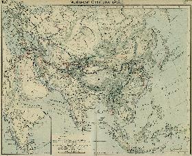
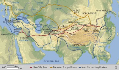
A Schematic Map of the Eurasian Trade Routes existing in the 13Th Century. Clearly marked in Red Accent on the Map are the cities of the network of land-bound trading routes through Central Asia known as the Silk Road (the path of Marco Polo and others).
WuWei
Yugur
Mongol
Tibetan
Sound Bonus: Marco Polo- "Alba in Pianura", by Rondo Venetiano.
Tibetan
Sunan Yugur Autonomous County o/t Yugur Nationality, Gansu Province, China (PRC).
Click Image to go to FULL Map Version !!
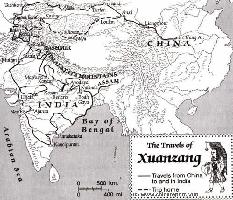
Route Map of Xuanzang's "Journey to The West" (India).
To Previous Page - Zhangye Main Menu - Introduction
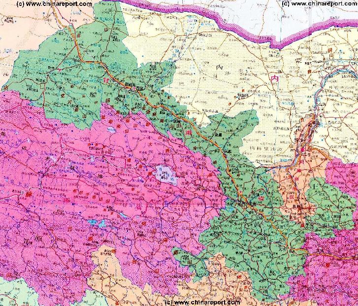
Dated back 5,000 years, Zhangye was a popular dwelling place, a natural area of plain, surrounded by Qilianshan and Helishan. At this time the area was considered Tibetan, part of the large area of influence that the present day province struggles to remember. Even today the Tibetan influence is still here, especially a little to the south around the village of Mati.

During a short period of the Ming Dynasty Zhangye even functioned as the Capital of Gansu Province.
Click to go to Full Version Han Dynasty Empire & Connections Map !!
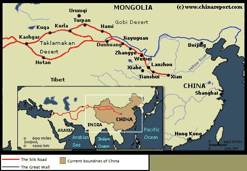
Map of China during the Rule of the Han Dynasty (206 BC - 221 AD) with the main trading roads of the Empire, the Silk Road and location of Huixian marked.
Zhangye + City Prefecture
As summarized in short above, Zhangye City knows quite its history. In fact, it was founded over 2000 years ago, officially during the Han Dynasty, but probably long before.
During the early Han Dynasty Zhangye was no less than the Capital City of the North-Western Regions of China, and thus it became the corner-stone and stepping-off point for the Han Dynasty Emmissaries who would help explore, found and later dominate the trading routes that would become famous in history as "The Silk Road".
Already during the succesful years of the Han Dynasty, "China's first Golden Age", Zhangye grew to be
a thriving City, a center of commerce, an important administrative center and military strongpoint, and a market city for international trade. Here, at roughly halfway the length of the Hexi Corridor was where many traders from Central Asia traveled to pick up wares at the local Market, bundle them up and carry them back to the West by Caravan.

Although after the Fall of the Han Dynasty the Rule of these territories temporarily reverted to the leaders of native local Population, Zhangye would be conquered again and included in the Empire of the Northern Qi Dynasty (a part of the so called Six Dynasty Period 420 AD - 589 AD).
For centuries it a stop-over on the busy and once more flourishing Silk Road of the Tang Dynasty (618 AD - 907 AD) and, overtime, it was included as a integral part of the Chinese Nation. A renowned traveler from this Era, known as the Monk Xuan Zang traveled from the Capital of China
at Chang'An (Xi'An) through Zhangye to reach the Yumen - Jade Gate at Dunhuang where he managed to slip out of the Empire on his way to India, homeland of Sakayamuni Buddha. He returned to a Heroes welcome and is largely credited with the spread of Buddhism in China during the Tang Dynasty.

Although the Mongols descended upon the Continent and established the Yuan Dynasty to Rule the Cathay Khanate (China) they adopted Chinese Features and left the town of Zhangye untouched. It was during this period, in the second half of the 13Th Century when Marco Polo reached the town from the Silk Road pathways in the West. Since Marco Polo stayed for a long period, around a year, he had ample time to get acquainted with the Town, the region, the monuments and its people. However, sadly, Marco Polo wrote far less than one might have expected. The few things Marco Polo did mention led to many questions in the West, since in his writings he had reported a community of Christians in these remote far Eastern Regions. Soon other Westerners would follow in an attempt to find out some answers.
(For more on this subject read: Jiuquan City , History of Jiuquan, Bento De Gois and/or Chronology of the Silk Road).

The later revival of Chinese Power during the early Ming Dynasty in which the Silk Road as well as the Great Wall defenses nearby played an important role in National Finance and Pride, left some distinct architecture specific for that era. Zhangye remained steadily inside the Chinese Empire throughout most of the following Centuries, although at the end of the Qing Dynasty (1368 AD - 1644 AD various Islamic Uprisings occurred. Thus, even today a visit to Zhangye is a visit to a distinctly Chinese City with according architecture and features, regardless of its multitude of ethnic peoples.

For the Complete History of Zhangye City & Prefecture, click through to the History of Zhangye Page.

Marco Polo - today rhubarb grows on the base of mount Yianzi, which is mountain seperate from the Qilian Shan.
Everything about the Imperial Palace & the Last Two Dynasties !
Click Image to View Book in Online Store !
Source DVD
"Children of Huangshi"
(starring Chow Yun Fat)
( available from our Online Store )
Ejin Qi (Inner Mongolia)
Baiyin
Baiyin
Yinchuan, Capital of Ningxia Province
This page was last updated on: July 22, 2017
My Great Web page
Zhangye History
Zhangye Landmarks
Zhangye
Gansu Sources
Gansu Province
Baiyin Home
Gansu Province Home
China Offline Sources
AsiaReport.com Home
China Report Home
China Online Sources
China Online Store
China Maps
China
China Photo Galleries
China Report Club
Wuwei
Wuwei Home
Baiyin Prefecture
Zhangye Home
Tianshui
Tianshui Home
JiaYuGuan
JiaYuGuan Home
JiuQuan Prefecture
Aksay AC Home
Dunhuang City Home
JiuQuan Home
Dingxi Home
Dingxi Prefecture
Gannan Home
Gannan Prefecture
Lanzhou
Lanzhou Home
Huixian Home
Longnan Prefecture
Pingliang
Pingliang Home
Linxia (Hui) Prf.
Linxia Home
Qingyang
Qingyang Home
Jinchang
Jinchang Home
Gansu Economy
Gansu History
Gansu Monuments
Gansu Maps
Gansu Minorities
Yellow River in Gansu
Zhangye Maps
Zhangye Minorities
City Landmarks
Counties + Landmarks
Minle County
Zhangye Sources:
Linze County
Gaotai County
Shandan County
Sunan Yugur County