A Full listing of Macau SAR Landmarks, Monuments, Hotspots and other sites of importance in alphabetical order. Search through the list to find your Full Report and Photo-Virtual Tour of each monument or landmark within the City, or Region of Macau SAR on the coast of Guangdong Province of China (PRC).
Public Transport in Macau
There is no information available on the Tourist Port Facility of Macao island.
In the 15Th Century and thereafter Macau became a base for European traders, mainly the Portugese, to do business with the Chinese mainland.
In the wake of the trading ships followed the diplomats, politicians and also those inspired with religious fervor. As for the conversion of Eastern, Asian peoples to Christianity, most of the first works was done by a small group of Jesuits.
Among the Jesuits who passed through Macau on their way to China were many, in fact all but 1, the benevolent and daring Bento De Goes (1562 AD - 1607 ADJiuquan, Gansu Province), who was sent through the landbound Silk Road in order to find out of the new found Nation of China was indeed the very same nation described by Marco Polo as Cathay (as it was known during the Yuan Dynasty). To give a short list of the most important
Today Macau is mainly known for its Tourism Industry, among which the Casino's and an army of Prostitutes. The Main scenic site of the fully modernized City of Macau is the former jesuit Portugese styled Cathedral of Macau.
There is no information available on the Ethnic Minorities of Macau SAR at this Time.
There is no information available on Hotels in Macau City and Prefecture at this Time.
Located in the coastal region south of China, Macau has a humid subtropical climate, with average relative humidity between 75% and 90%. The seasonal climate is greatly influenced by the monsoons and monsoon season, and thus differences in temperature and humidity between summer and winter are marked. The average annual temperature of Macau is 22.7 °C (72.9 °F). In July, which is the warmest month of the year, temperatures average around 28.9 °Celcius (84.0 °F). The coolest month by far is January, with average temperature 15.0 °C (59.0 °F). Extreme cold, freezing, sleet and snow are virtually unheard of in Hong Kong. It simply does not happen.
Macau has ample rainfall, with average annual precipitation being 2,030 millimetres (79.9 in). However, winter is mostly dry due to the monsoon from mainland China. Autumn in Macau, from October to November, is sunny and warm with low humidity. Winter (December to early March) is generally mild and sunny, although there can be some off days, with cloud cover and rain at times. Humidity starts to increase in spring from late March to June. In summer from July to September, the climate is warm to hot (often rising above 30 °C at daytime). The hot weather is often followed by heavy rain, thunderstorm and occasional typhoons.
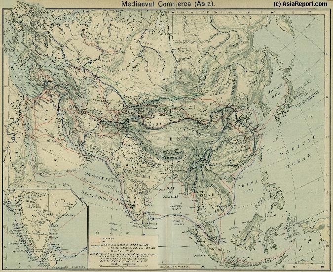
A Schematic Map of the Eurasian Trade Routes existing in the 13Th Century (Yuan Dynasty).
Clearly depicted on the Map are the land-bound trading routes through Central Asia known as the Silk Road (the path of Marco Polo and others) and the Maritime Trade Routes that operated between the Arabian Peninsula, the Indian Ocean and Coastal Cities, the Straights of Malacca and South-China Sea's. As shown Maritime Trade to China mainly entered through Southern Harbors, then was distributed internally by use of the Grand Canal, the Yangzte River and the Yellow River.
- CLICK MAP TO GO TO FULL VERSION -
Find DrBen and ChinaReport on Facebook with the latest from www.drben.net.
names; Father Matteo Ricci arrived in Macau in Augustof the year 1582 AD, sailing from Goa in India on the late monsoon winds. His later loyal companion and partner in China, father Michele Ruggieri had already arrived in Macau in the year 1579 AD. In 1583 Ricci and Ruggieri obtained permission to settle in Zhaoqing, a city on the Chinese mainland, where they moved after receiving an invitation from the governor of Zhaoqing at the time, Wang Pan, who had heard of Ricci's skill as a mathematician and cartographer. It would become the first Christian Community in all of China.
Much later, between 1657 AD and 1659 AD Prospero Intorcetta, another Jesuit priest sent from Rome in order to convert the Chinese, stayed on in Macau, as was customary in those days; in order to adapt to Chinese life and customs, and most importantly: study the language and phylosophy. Later Intorcetta would do missionary work in the Chinese City of Nanchang, be arrested for his religious practices and sent to Beijing for imprisonment and judgement by the Imperial Court. Having escaped this imprisonment he would then go on to re-enter China, continue his missionary work, and eventually wind up meeting the Emperor Kangxi. Read more in: 'Nanchang, Capital of Jiangxi Province'.
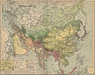
China Report - Colonialism - Growth of Colonies & Japan after 1801 AD
A Map drawing of the Eurasian continent , parts of North-East Africa and the Middle East in the 19Th Century between 1801 AD and 1900 AD. Focal points are the expansion of western colonial posessions of Portugal, Britain and France, as well as Russia moving from West to East. Labeled seperately is the later Rise of the Empire of Japan in the East.
Included in this Map are the main cities across the continent with their brief histories and events during the 19Th Century. Marked in Colors for clarity are the various colonial and imperialist Nations. As relating to China; special attention is payed to so called Treaty Ports. The First Treaty Ports were forced open by Britain in the year 1841 AD, but counted over 80 in total by the end of the 19Th Century. The most important Treaty Ports in China are marked and described with a short history where the map allows.