In Ningxia Hui Autonomous Region there are five sections of The Great Wall of China. Taken from East to West, the first of these is Yanchi County Great Wall of China. The others are Shuidonggou (水洞沟) (Coordinates: 38° 16′ 43.09″ North, 106° 31′ 53.45″ East), Dawukou (Shizuishan) also known as Jiucai Gou (Coordinates: 39° 4′ 7.97″ North, 106° 21′ 14.52″ East), Sanguankou as one of the passes in the Helan Mountains (Coordinates: 38° 20′ 48.72″ North, 105° 49′ 23.74″ East) and Songwei or Zhongwei (Coordinates: 37° 31′ 8.21″ North, 105° 10′ 54.41″ East). After Zhongwei the Great Wall continues across the border into Gansu Province where the first option to visit is the Gantang Great Wall of China site.
The Sanguan Great Wall can be found due South-West of Yinchuan, intersecting with the Provincial Road S102, before heading southward parallel to the Yellow River extending from the southern foothills of Helan Shan. The Sanguankou Wall is fairly long, starting a short way north of a Provincial Road S102 to Inner-Mongolia Autonomous Region, and stretching from there far past the Qingtongxia Hydro-Electric Dam to becoming intraceable north-west of Ertang Village (Ertang Cun). Originally, the wall connected all the way through to Zhongwei and the Zhongwei Great Wall in the south-west of Ningxia Hui Autonomous Region.
- (4) Sanguankou (三关口) Three Gates Pass (2) History of -
A Full Google Earth Supported Map Overview of All Structures of the Great Wall of China from East to West, by DrBen.Net (c) ChinaReport.com and Google.com.
My Great Web page
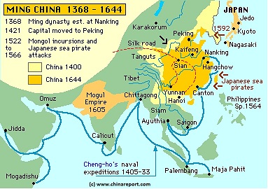
China Report - Map of the Great Wall during the Ming Dynasty
Satellite image of China and North-East Asia, with a super-imposed schematic Map of the location and Path of the Great Wall as constructed during the Reign of the Ming Dynasty. Included for reference are City names, geographical features of landscape, Names and locations of Passes on the Great Wall of China.
SANGUANGOU EARLY HISTORY:
History of human inhabitation of the lush Ningxia Plain and wider regions go back to 30.000 B.C. and sometimes as far back as 100.000 B.C. as has been proven by archeological finds in the region (see also: Shuidonggou Great Wall in Ningxia). Furthermore so called "rock art" - rock carvings with a ceremonial or other function can be found inside the passes and ravines of the Helan Mountains, spread along its length from north to south (See: Helankou Rock Art Museum and Helan Pass). It can thus safely be assumed that the San Guan Pass (earlier named: Chimukou) was already known to the earliest people inhabiting the regions.
EARLIEST CHINESE HISTORY OF SANGUAN PASS:
A first real mention in historic records of the Sanguankou Pass dates back to the Qin Dynasty (221 B.C. - 207 B.C.) and Han Dynasty (206 B.C. - 220 A.D.) Era's when the Ningxia Plain was first settled by the Han Chinese and made ready for agriculture mainly by irrigating fertile lands that would otherwise be far less productive (Read more in: "History of Ningxia (1 through 5)".) Overtime, as the region was developed and became an official territory divided into counties during the Han Dynasty, one of the weak spots in the local natural defenses provided by surrounding deserts, the yellow river and the Helan Mountains proved to be the Chimukou, which at the time was the name for what today is the San Guan Gou.
Nomadic peoples had been using this route to reach this fertile plain for centuries if not millenia previously, hence when the plain became populated with farmers and Chinese towns and cities, the nomadic peoples knew how to use it to their advantage and fall upon the Chinese unexpectedly. Over the centuries nomadic tribes would repeatedly invade through the pass, only leaving after taking their loot from the helpless farmers.
Through the following centuries, even after the fall of the Han Dynasty in 220 A.D., Ningxia would remain a hotly contested and very strategic region, always promising a rich harvest, but at the same time in a volatile frontline position, exposed to frequent raids and invasion. At times, the Ningxia Region fell out of the central Chinese Empire for considerable time, but always, whenever the Han returned to claim the land they would attempt to protect it.
Eversince the Han Dynasty, Yinchuan remained an important garrisson station along the outer defense perimeter of the Empire, retaining this key military position at least until the fall of the Ming Dynasty in 1644 A.D. In fact, during most of this long period, Yinchuan and Yulin in the north of neighboring Shaanxi Province were the two key defensive strongholds in the entire central-western front with the nomadic tribes.
CHIMUKOU - SANGUAN PASS DURING THE WESTERN SUNRISE PERIOD OR TANGUT EMPIRE:
Overtime, of course, military defenses were thrown up to protect the Ningxia Region, resulting in a fortress with garrisson to guard the pass of the crucial pass at Sanguan (Chimukou). At which time the first castle at San Guan Pass (Chimukou) was built is hard to say, but it is known that the pass was well guarded by the time of the emergence of the Tangut (Xixia) Dynasty (1038 A.D. - 1227 A.D.) with its Capital at Yinchuan. In Fact, as described in "History of Ningxia Hui Autonomous Region (1 through 5)", in the year 1209 A.D. when the Great Genhis Khan led his armies on an invasion of the Tangut Realm, it is recored that the pass was protected by a large fortress with according garrison and abundant cavalry. However there was no wall inside the Pass (the Great Wall of the Qin and Han Dynasty are found in other locations), thus after using a now renowned Mongol tactic and luring the garrisson out into the Tengger Desert to be massacred by a turning Mongol Army, the way lay wide open to the Capital of Ningxia.
In short, in 1209 A.D. the Tanguts were forced to become the subservients of the united Mongolian Tribes to the North and the throne of Genhis Khan (Temujin). Left with their own leadership and culture intact, the Tangut subsequently and unwisely rebelled.
In the fateful year 1227 A.D. their culture and civilization was crushed when, predictably, a reinvasion by a vengeful Mongolian Army occurred. As a punishment for their arrogance the Tanguts were massacred to the very last man, woman and child (although according to legend it took over 80 years to track all of them down). In the blood-soaked process the Tangut culture was completely wiped out, leaving but ruins and relics of the extinct culture and a very bitter memory to keep for the Han Chinese, who used to be the masters of the regions.
China too would be overrun by the Mongolian hordes, however, when eventually they returned they remembered the causes of the extinction of the Tangut People all too well. It is for this reason that the Sanguankou and other Great Wall Sections were built. Naturally, the Sanguankou was most important, another defensive gap that the Chinese military thinkers felt they had to close was in a location to the East of Yinchuan, where in 1227 A.D. the Mongol Armies had re-appeared out of another desert, to bring doom to the Tanguts. This gap is today known as the Shuidonggou Great Wall of China.
SANG GUAN KOU DURING THE MING DYNASTY (1368 A.D. - 1644 A.D.) :
Although the Ming Dynasty Era is known for its impressive rebuilding and strenghtening of the continuous defenses known as the Great Wall of China, and eventhough it was known were the weak spots in the defenses were located, it is cetainly not true that the Ming went to work on the Great Wall of China sections found in Ningxia Hui Autonomous Region straightaway. In fact, for various interesting historic reasons, no Great Wall of China Sections were built within Ningxia until the tenth year of the Jiajing Reign (1521 A.D. - 1567 A.D.) of the Ming Dynasty, which amounts to the year 1531 A.D., well after the death of the Great Founding Emperors of the Dynasty.
Among the main reasons for the delay that can be identified today are, firstly, the fact that in the year
Inner Mongolia Autonomous Region Map 1A - Geographic Map
A Schematic Map overview of North & North-Eastern China's Inner Mongolia Autonomous Region entire, clearly delineating borders and including sections of all bordering Nations as well as bordering Chinese Provinces and Autonomous Regions of China.
Map and description include Main Cities and Towns, Main Monuments & Landmarks of Inner Mongolia AR and adjacent provinces & regions, the locations of the Great Wall of China inside the Map Area, major highways and road connections, provincial railroads and main railroad-stations, and main waterways, rivers and lakes of Inner Mongolia AR and wider region. This Map further provides links to on site photos and information on Cities, Main Monuments & Sights of Inner Mongolia.
Micro-Map providing an overview of the Ming Dynasty Empire over time. Clearly, in the early Ming Dynasty Chinese territories were largest (1400 AD). The later reemergence of the Mongolian Armies brought the outer border of the Empire closer to the Ningxia Region. The Great Wall of China extends as far west as Jiayuguan, which forms the ultimate western border of China during most of the Ming Dynasty.
In the same map, the known and proven routes of Chinese maritime missions to south-east asian islands, India, the Arabian peninsula and the African east coast under command of Admiral Zheng He. All maritime missions ended in the year 1433 A.D.
1368 A.D. the Mongolians had been utterly defeated and driven outside the Jiayu pass (Jiayuguan, Gansu Province), thereafter retreating in panic back to their homelands far in the North. It would take some time for the Mongolian Armies to reorganize, recover and return to the southern regions.
As the Mongolians stayed away, the Ming would concentrate on the building of defenses in the far West, with the main goal of reopening to vital economic artery of the Silk Road. With hostile Mongolians and other hostile tribes lingering in the regions, this was difficult enough. Several Chinese Military campaigns to the north of Ningxia may also explain why no wall was built in Ningxia in the early Ming Dynasty.
Secondly, at the end of the 14th century, the emerging Ming Empire was plagued by inner strive in the Imperial Family, resulting in all out Civil War ending with the siege and fall of the Capital at Nanjing, in current day Jiangsu Province. Thrown into inner turmoil, efforts at outer defense were lagging.
Thirdly, under the legendary Zhu Di, third Emperor of the Ming Dynasty(Yongle Reign: 1402 - 1424 A.D.), great and very ambitious projects were launched on several fronts. Not only was part of the Great Wall of China (in the East) rebuilt in this period, at the same time the Capital was moved from southern Nanjing to the North, creating an entirely new neverbefore seen Imperial Capital, what was intended to be the greatest Capital of the entire world, the center of the world as the Chinese knew it then. The costs of the building of this city, the city of Beijing, its Forbidden City (Palace Museum), the Ming Tombs and several Imperial Temple complexes came down to a staggering cost to the Imperial Coffers.
Fourthly, as if all this was not enough already, the Chinese embarked on what has become
known as the Chinese Maritime Age (1405 A.D. - 1433 A.D.), sailing an incredible fleet consisting of the largest wooden ships in human history, halfway along the world, and as some historic evidence strongly suggest, indeed around the entire planet. If this in fact happened then the Chinese were the first people in history to achieve this staggering feat.
With all of these gargantuan projects and problem taking the attention of the Chinese Court and Leadership, the full protection of the population in the Ningxia Plain remained an outstanding problem for several centuries. It was only after the termination of the overseas missions (1433 A.D.), and the reemergence of the Mongolians as a viable military power to the north that things started to change in these parts.
The most notable local event that occured was the return of Mongolain nomadic raiders and their families to several strategic points within the reaches of what today is the arid Ordos desert to the East of Ningxia proper in the early .. century. Their return alarmed the Ming Commanders responsible for the defence of the region, as this signalled the start of a well-known and repeating process. If the Mongolians were allowed to retake the Ordos Region, more raids would be coming the way of Ningxia.
Opportunity knocked in the year ...
The Great Wall at Sanguankou was constructed during the Ming Dynasty (1368-1644), in the tenth year of 嘉靖Jiajing (Emperor Shizong) (1531 A.D.). Nine years later, the Wall was rebuilt again because the earlier Wall was levelled by sandstorms. The new Wall was a composite of local gravels, and imported soil and water. It is recorded that materials used were transferred from distant mountainous areas. It runs about 80 km. south, across level plains in an almost straight arrow, until it ends not far from the right angle bend of Huang He (Yellow River (黄河)). Today, a major highway runs through it at the pass, connecting Yinchuan city and 阿拉善左旗Alashanzuoqi in Inner Mongolia Autonomous Region.
The pass tower is a fortress and is for the border defense security in Sanguankou. There remained the ruined Great Wall in the important pass. Three passes are from east to west, supposing the first toll-gate, the second toll-gate and the third toll-gate. The range twists and turns and the terrain is steep and grand.
In 1531 completed, the 80 kilometers long Great Wall south from the dam fort to north Sanguankou was constructed but was later filled and leveled up by the sandstorm. The first toll-gate wall from north to south is connected with the Great Wall where it is an open mountain area. There are frusta in each section of the corner of the wall, the wall and the frusta were already damaged and were kept only for the partial base.
The pass on the south side has more than 20 meters High Mountain. Located here are one 11-meters-square and 8-meters-high frusta. The three passes are clamped by two mountains. The mountain is steep and the terrain is extremely important .They built the stone Great Wall and one deep ditch along the pass.
SANGUANKOU DURING THE QING DYNASTY (1644 A.D. - 1911 A.D.) :
Nothing is known or at least reported about the Sanguankou Pass during the Qing Dynasty except for the fact that levies were imposed on tea- and other trade caravans passing from the Chinese heartlands through Yinchuan and Sanguankou to the Mongolian lands and Central Asia (Read: The Tea Road by Martha Avery). Even before the advent of the Qing Dynasty in China after the fall of Beijing in 1644 A.D. , the Manchu had first solidified their influence over most of Mongolia and today's Inner Mongolia Autonomous Region, thus after their take-over of China there was no need for a Great Wall of China and allegiances with tribes beyond its (former) boundaries kept the unruly tribes of the north in check, and trade helped keep things that way.
SANGUANKOU IN THE WARLORD ERA:
Again, nothing much can be reported on events along the Sanguankou and its Great Wall of China during the years between the fall of the Qing Dynasty in 1911 A.D. and the final victory of communist forces in the Chinese Civil Wars in 1949 A.D.
So far it is known that the Wuslin Scientific Mission, sponsored by the National Geographic Society in the United States of America, passed through the Ningxia Region in the year 1923 A.D. chosing a route that would lead them through the regions were the Sanguankou Great wall of China was built. However, sadly, so far no trace or mention of the Sanguankou has been revealed from the scientific and other notes taken by the mission (Frederick & Janet Wulsin), nor are there any fotos of the Sanguankou Great Wall or parts thereof taken by the expedition members.
As can be identified from the book "Vanished Kingdoms" by Martha J Cabott (daughter of Janet Wulsin), the Wulsin's route took them from Yinchuan to the south-west towards the Sanguankou Great Wall of China. The Wulsins however traveled along the West Bank of the Yellow River, following the water upstream and keeping in sight of its safety, which clearly means they never passed through sanguan pass. On the other hand, as the southern sections of the Great Wall of Sanguankou extend from the pass some 80 kilometers southward, following the line of the river, there is little doubt that the Wulsins must have seen it at some point.
In the end, trudging through, around or over the sand dunes lining the xintongxia gorge, the Wuslins eventually reached Zhongwei and Shapotou, where the crossed over the Yellow River using its rafting pond service. A Great Photo remains of the Wulsin expedition standing on a sand dune overlooking the bends of the slow flowing yellow river passing by Zhongwei. Again, no mention is made of the Great Wall of China section that extends along the north rim of the town of Zhongwei either.
One might think the Wuslin's simply were not interested in the Great Wall, however study of the photographs taken by the Wulsins on their treck through China (See Link: Peabody Museum of Harvard University, Wulsin Mission in China; Online Collection) reveals that they took many photos of the Great Wall in other parts of China (mainly northern Hebei Province and Shanxi Province). No reasons can be found for the Wulsin's missing out on the Ningxia Great Wall, altogether at 4 different locations.
China Report - Map of the Gobi Desert & Yellow River Flow
A Satellite Image Map of the Entire Gobi Desert Region. Map overviews North-West Xinjiang Autonomous Region, Mongolia, Inner Mongolia and North and North-Eastern China giving a Full Overview of the Gobi Deserts. Clearly visible details of geographical features such as mountain ranges, rivers, valleys and lakes.
Map includes country borders, name and location details of Cities and Villages (clearly visible).
Mouse over Image to Reveal more information and follow the flow and path of the yellow river from Xining in Qinghai Province to the Bohai Sea. Details of old / former Yellow River flow (south of new) and new trajectory to the Bohai Sea.
SANGUANKOU DURING THE PEOPLES REPUBLIC 1949 A.D. - Today) :
During much of the early history of the Peoples Republic of China many area's around Yinchuan City were designated military area's and therefor strictly off limits, especially to foreigners. Only in the late 1980's the situation in the whole of China had changed enough for foreign visitors to gain access to the Provinces and the Ningxia Great Wall. Of Sanguan pass it is known that it was closed to the public and part of an airforce targeting range. According to an early visitor to Sanguankou, John
Man - who later wrote a book on the Great Wall, at the time the hill sides were painted with large numbers in bright red, providing targets for artillery practice and aircraft practicing bombing runs. During the late 1960's, when there were high tensions with the Soviet Union and Mao Zedong feared a full scale invasion from Russian Tank batallions lying just across the border within the Republic of Mongolia (then part of the U.S.S.R.), activities in the military area's of Ningxia was reportedly very high.By the time John Man arrived however, the area had been handed back to civilian authorities and today, no visible sign remains of the military practice of the past.
Find DrBen and ChinaReport on Facebook with the latest from www.drben.net.