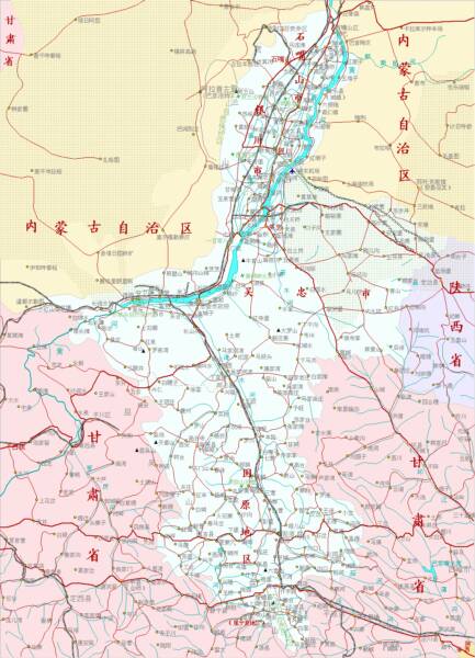
In Ningxia Hui Autonomous Region there are five sections of The Great Wall of China. Taken from East to West, the first of these is Yanchi County Great Wall of China. The others are Shuidonggou (水洞沟) (Coordinates: 38° 16′ 43.09″ North, 106° 31′ 53.45″ East), Dawukou (Shizuishan) also known as Jiucai Gou (Coordinates: 39° 4′ 7.97″ North, 106° 21′ 14.52″ East), Sanguankou as one of the passes in the Helan Mountains (Coordinates: 38° 20′ 48.72″ North, 105° 49′ 23.74″ East) and Songwei or Zhongwei (Coordinates: 37° 31′ 8.21″ North, 105° 10′ 54.41″ East). After Zhongwei the Great Wall continues across the border into Gansu Province where the first option to visit is the Gantang Great Wall of China site.
The Sanguan Great Wall can be found due South-West of Yinchuan, intersecting with the Provincial Road S102, before heading southward parallel to the Yellow River extending from the southern foothills of Helan Shan. The Sanguankou Wall is fairly long, starting a short way north of a Provincial Road S102 to Inner-Mongolia Autonomous Region, and stretching from there far past the Qingtongxia Hydro-Electric Dam to becoming intraceable north-west of Ertang Village (Ertang Cun). Originally, the wall connected all the way through to Zhongwei and the Zhongwei Great Wall in the south-west of Ningxia Hui Autonomous Region.
(4c) Sanguankou (三关口) Three Gates Pass - Road Directions
A Full Google Earth Supported Map Overview of All Structures of the Great Wall of China from East to West, by DrBen.Net (c) ChinaReport.com and Google.com.
My Great Web page
China Report - Map of the Great Wall during the Ming Dynasty
Satellite image of China and North-East Asia, with a super-imposed schematic Map of the location and Path of the Great Wall as constructed during the Reign of the Ming Dynasty. Included for reference are City names, geographical features of landscape, Names and locations of Passes on the Great Wall of China.
The Sanguan Pass is situated on the border between Yongning County of Yinchuan Prefecture in Ningxia Hui Autonomous Region and the Bayan Nur Prefecture of Inner Mongolia Autonomous Region and in ancient times formed the border between Chinese held territory and lands at least nominally belonging to nomadic tribes of Mongolian origins. Although National borders have shifted since and Inner Mongolia has been incorporated into the Peoples Republic of China, by and large the pass still marks the border between the irrigation agriculture and urbanized living of the mainstream Chinese and the more barren lands beyond. The lands situated outside of the three gates pass are considered parts of the Tengger (or Tenggeli) Desert, which today should be considered more deadly than in the great blossoming days of the Silk Road or during the Mongolian conquests that set the stage for the rise of the Mongolian EurAsian Empire (and included for the first time the lands on both sides of the Helan Mountains).
The Three Gates pass itself cuts through the lower southern Mountains and foothills that are part of the Helan Shan range. It is situated at quite some distance from the Capital of Ningxia Hui Autonomous Region at Yinchuan, altogether some 65 kilometers. The Wall at Sanguan forms the extreme westernmost border of the Yongning County of Yinchuan City Prefecture and borders on the Bayannur Prefecture (Previously until 2003 League). As such, the main route from the city of Yinchuan leads through both the Xixia District (named after the acclaimed Tangut King Tombs a.k.a. Xixia Wan Ling) and the Yongning County.
To be more precise; to get from the most scenic part of the city, the Old City (Xingqing) District, to the Pass one needs to follow a road westward out of town. As one can gain from the available Google supported Satellite Image Maps, this leaves several boulevards available.
Which ever initial route one takes, experienced drivers know that eventually one needs to end up on the S102 Provincial Road, which currently runs along the southern outskirts of the city. Fortunately, due to the grid of parallel roads S102 is nearly impossible to miss.
Once having found the S102 Provincial Road in the south or south-west of the city, follow it in the western direction. Once outside of the city proper, the S102 road will curve to the south and snaking through the flat land of the Ningxia Plain will start climbing slowly towards the granite wall of the Helan Mountains visible ahead.
En route to the famous historic pass, one will pass by Yinchuan's substantial army base which lies hidden in the outskirts of town along the all important route to the pass.
Directions to Sanguangou from anywhere in Yinchuan are fairly simple. From either the old or the new city, just head south along a main boulevard until meeting up with the Yinchuan Expressway, which is a ring road surrounding Yinchuan. Get onto G0601 Expressway, the ring road, heading westward towards the Helan Mountains.
The Sanguangou Great Wall is situated along S102 Provincial road, which leads off the south-west corner of the ring road that surrounds Yinchuan. While the expressway turns northward, turn off the expressway to head south-west onto S102 Provincial Road. From there simply the road bends slightly westward around Pingjibao Farm. You will not recognize the farm but keeping following the road and do not turn off at the next crossroads (with G110 National Road turning back north-east ward and confusingly S201 turning southward). Drive straight on to follow S102 for a few more kilometers and keep your eyes peeled. The first signs of the vicinity of the Great Wall are made up of a few beacon towers standing in the steepening plain. Next along the route one can notice remains of an inner layer of the Great Wall to the South. The mud brown remains of the main line, the 2nd gate, of the Great Wall at Sanguankou can be found further
up the road inside the pass itself.
On the outside of the Great Wall ruins, a considerable distance further into the pass a seemingly purposeless ditch intersects with the road, leading away at both sides north- and south. This 4 meter deep and 4 meter wide ditch is the third wall and third gate at Sanguan. There was no wall in the third layer, but this ditch and no doubt horse-traps and spikes.
The Great Wall leads only a short stretch into the mountains north of Sanguankou after which it disappears from sight untraceable due to erosion and the sharp cliffs of the landscape.
In the south the Sanguankou Great Wall can be followed for miles until it terminates in the desert way beyond the Xintongxia hydro-electric dam of the Yellow River (Huang He).
Study the Google Map to find your best approach to the Sanguankou Great Wall for your hike. A great idea would be to bring a compass and if you can a physical map of the area.
(Maps of Ningxia and Yinchuan may be available at Xinhua Bookstore in the old city district of Town just across from the Drum Tower).
Once at the Bus Station, select the Bus Route to Bayan Hot which is a small town located on the other side of the Helan Mountains within Inner-Mongolia Autonomous Region. Tickets are 10RMB per person at this time (2012). The bus trip to Bayan Hot takes about 2 hours however its route passes through the Great Wall after about 30 minutes giving passengers the opportunity to see it up close.
According to several travelers one can ask the bus driver to drop one off at the Great Wall.
As written by one early explorer: "Have your eyes on the lookout for the Wall and get off where you see fit. My first bus driver forgot to drop me off and I did not notice the wall; so for 1.5 hours I was whistling along barren red-brown hills that lined both sides of the road. I got off (in Bayan Hot) and waited on the lone road with the wind smacking me for being unattentive. On the bus back, my head was glued to the window. So be aware: the Wall is easily hidden by the hills beside the road".
Another notice should be given, as there are three seperate layers of the Great Wall giving it the name San Guan Kou (Three Gates Pass). In order to find your way to the correct wall remains, please note that the inner layer of the Great Wall lies 9 kilometers from the 2nd layer, which is also the most important and most visible part of the Wall. This second layer is built straight across the narrowest part of the Pass, so keep this in mind.
The third layer lies yet another 1.5 kilometers further in the direction of Inner-Mongolia, but is far less interesting since it
only consists of a 4 meter deep and 4 meter wide ditch that is rather hard to locate and identify from afar.
Find DrBen and ChinaReport on Facebook with the latest from www.drben.net.
The best way to get to the San Guan Kou is probably by hired car or by means of a Taxi. The distance from the Old City of Yinchuan to the actual site of the Wall is too large to attempt a visit by bicycle. Only rarely determined individuals with enough spirit bicycle up to the Three Gates Pass in a day , pauze at the Great Wall pass and continue onwards to the town of Bayan Hot. It is a dangerous route. Not only due to abundant traffic but also given the fact that more than half of this route leads through parts of the Tengger Desert which is especially barren and windy as well.
To be complete, the town of Bayan Hot, the main urban center of BayanNur Prefecture, lies at a distance of some 65 kilometers from the San Guan Kou. The moon lake, which gave its name to the county town lies at an even greater distance of 75 kilometers, smack in the middle of the dangerous Tengger Desert.
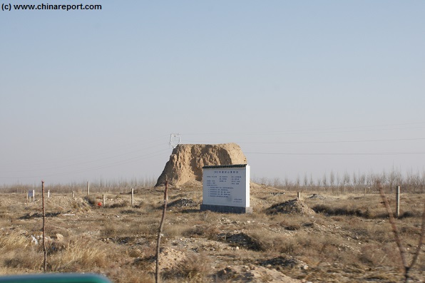
The eroded but still solid rammed earth core of a beacon tower marks the route up to the Three Gates Pass (San Guan Kou) of the Great Wall of China due south-west of Yinchuan (Photo: November 2014).
Next up, in the flat and empty grasslands one can catch sight of the Tangut King Tombs site, although it is only visible in the distance while driving along the one highway leading up to the pass.
(Turn back from this point on S102 Road to connect with G110 Road leading up to Xixia Wan Ling)
At some point beyond and on the opposite (south) side of the road the first remaining fire beacon tower that belongs to the Three Gates Pass defenses of the Ming Dynasty Era stands at some 40 kilometers due south-west of Yinchuan along S102 Provincial road which leads to the mountain foothills an through the pass into Inner Mongolia Autonomous Region. However, from the location of this Beacon Tower it is still a large distance to the actual pass and gate itself.
One of the several major Mausoleum sites of the Tangut Kings in the rocky plains underneath the Helan Mountains as seen from S102 National Road. The main tourist reception point and largest Mausoleum is situated at some distance beyond and out of sight on most days.
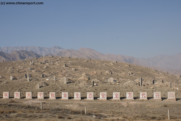
To bridge the last distances to the actual Pass, simply continue along S102 Provincial Road until it reaches the Mountains. Among the foothills on the north side of the road one can make out a desert cemetery consisting of a multitude of Tomb hills and Stone Steles as the local Feng Shui further augmented by the presence of the Tangut King Tombs and the ancient Great Wall is considered to be quite auspicious.
Cemeteries small and large are a sight not uncommon along the Great Wall of China in the north and west. In fact, similar tombs can be found along the wall. In these regions, where populations are as yet not as high, and space is still available, upon death people are not usually cremated but often buried. Given the desert conditions proven by the continuing existence of the underground Tombs of the Tangut Kings, the dead may rejoice in the foresight of a lengthy preservation of their mummified body into the future. Perhaps they too, will one day become a historic tourist destination.
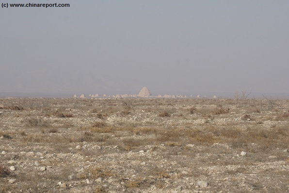
Just beyond the cemetery hills the route swerves sharply to face the mountains. At this point one can clearly see a broken mud tower riding atop the first cliff and overlooking the plain and road below. This is the first part of the now mostly broken and fallen northern section of Sanguankou Great Wall. Just beyond, about half a kilometer, the mountains open into a fairly narrow pass between steep and sharp cliffs. This is the narrowest section of the pass and the location of the main wall as it was positioned in the past. Beyond lies over a kilometer more road between mountains, and the barely recognizable two outer layers of the defenses of the Three Gates Pass. The road beyond the Great Wall inside the pass changes it name into S218 National Road and continues for 65 kilometers to Bayan Hot (also: Bayan Nur).
Substantial Cemetery upon a Hill found along S102 Provincial Road just inside the Three Gates Pass and its remaining Great Wall of China ruins. Desert conditions allow for an interment and mummification. Due to its good Feng Shui the hill is a popular last resting place.
Alternative routes to the Sanguankou do exist. That is, recent developments and needs for transportation between the Ningxia Hui Autonomous Region and what have now become the mining regions -not grasslands- of Inner Mongolia have yielded the construction of the S27 / S5 Expressway, a toll road and major highway which makes a wide curve due south of the original route taken by the S102 Road. Not only is this route longer, it is also a pay road and thus less attractive. Local drivers, especially cabies clearly still prefer the old S102 over its newer and luxury version. Indeed it gives a better view of the relevant landmarks along the road as described on this page.
In the end, both roads come together at the pass anyway. It is unlikely that in the future this situation will change with the S102 road being cancelled.