Geographic Maps on Lanzhou City and Area of South Gansu Province.
This page was last updated on: July 24, 2017
Gansu Province of China
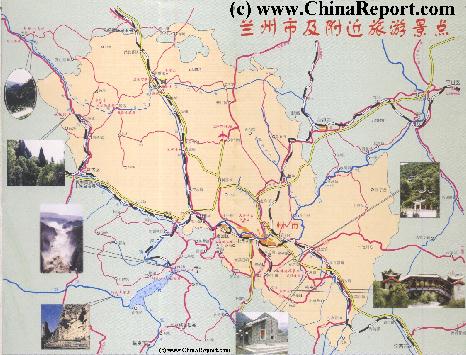
Lanzhou City Province Maps - Index
Lanzhou City Maps
ChinaReport.comat
Great Wall of China Path & Locations Map
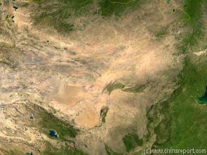
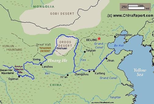
Map of the Gobi Desert & Yellow River Flow
A Satellite Image Map of the Entire Gobi Desert Region and the realtive position of the City Datong in it. Map overviews North-West Xianjiang Autonomous Region, Mongolia, Inner Mongolia and North and North-Eastern China giving a Full Overview of the Gobi Deserts. Clearly visible details of geographical features such as mountain ranges, rivers, valleys and lakes, national borders, name and location details of Cities and Villages (clearly visible).
Mouse over Image to Reveal more information and follow the flow and path of the yellow river from Xining in Qinghai Province to the Bohai Sea. Details of old / former Yellow River flow (south of new) and new trajectory to the Bohai Sea.
The Lanzhou City and Province Maps Index gives acces to all Maps relevant to Lanzhou City and City Prefecture and Area's of Specific Interest within that region. Please use these Maps to find your way easily around the City, Prefecture, Autonomous Minority Area's and many Monuments & Landmarks.
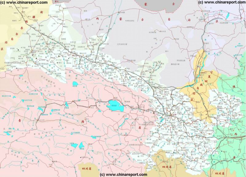
Gansu Province Map 1 - Geographic Map
A Geographic overview Map of Gansu Province entire delineating provincial borders and parts of neighboring Xinjiang-Uygur Autonomous Region Province and Qinghai Province in the West, Inner Mongolia AR and Ningxia Province in the North, Shaanxi Province to the East and Sichuan Province in the South. Includes Cities and Towns (shown by size), Main Monuments & Landmarks of Gansu Province, the flow of the yellow river through Sichuan, Qinghai, Gansu and Ningxia Provinces, BingLing Si, Maji Shan and Mogao Caves UNESCO World Heritage Sites, Main Mountains (with Height), major highways, provincial railroads and main railroad-stations, and main waterways & rivers. This Map further provides links to on site photos and information on the Cities and Main Monuments Other sites will be included in the Future.
Gansu Province Map 2 - Schematic Map
A Schematic overview Map of Gansu Province entire delineating provincial borders and Main Landscape Features in Gansu and parts of neighboring Xinjiang AR and Qinghai Province in the West, Inner Mongolia AR and Ningxia Province in the North, Shaanxi Province to the East and Sichuan Province in the South. Includes Cities and Towns (shown by size), Main Monuments & Landmarks of Gansu Province, the flow of the Yellow River along the borders through Sichuan, Qinghai, Gansu and Ningxia Provinces, BingLing Si, Mogao Caves and Maiji Shan UNESCO World Heritage Sites, Deserts, Mountains (with Height), major highways, provincial railroads and main railroad-stations, and waterways & rivers. This Map further provides links to on site photos and information on the Cities and Monuments.
A Satellite image Based Map of China and East-Asia, with a super-imposed schematic Map of the Location and Path of the Great Wall as constructed during the Reign of the Ming Dynasty.
Included for reference are Locations and Names of Passes on the Great Wall of China and their significance. Further Reports link to More Photos and History & Backgrounds of each Great Wall of China Site. Further depicted are City names, geographical features of landscape, rivers and more.
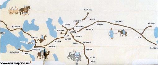
Map of the Ancient Silk Road during the Han Dynasty & Roman Age 2
A Schematic Map depicting the Full Length and main pathways of the Ancient Silk Road during the Han Dynasty Period (206 BC - 221 AD) and Roman Age (30 BC - 630 AD).
In 30 BC the Roman Empire started trading with India, which was already well known from the
Conquest of Alexander the Great (+/- 330 BC). In the following 6 centuries the West would Trade with India and indirectly also with China through the Silk Road. The Silk Road only lost its Value after the European Age of Discovery and the Establishment of Maritime Trade Routes with India (16Th Century) and later China. The Yellow River is crossed at Lanzhou, after which Dunhuang is the Last Station in China.
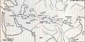
Map of the Ancient Silk Road during the Han Dynasty & Roman Age 1
A Schematic Map depicting other details along the Full Length and main pathways of the Ancient Silk Road during the early Han Dynasty Period (206 BC - 221 AD).
As seen from China the Silk Road extends due Westward from Chang'An (Xian) the Han & Tang Dynasty Capital. The Yellow River is crossed at Lanzhou, after which Dunhuang is the Last Station. This
Map depicts the Lost Civilizations of Loulan and Hotan, as well as the south route and north route of the Silk Road coming together at Dunhuang in current day Gansu Province of China.
Map of Lanzhou City Prefecture of Gansu Province
A rough Geographic overview Map of Lanzhou City and City Prefecture of South Gansu Province. Map depicts Lanzhou's five city districts stretched along the Yellow River Banks, four outlying counties.
Sites and locations included are main highways and roads, Lanzhou Zhongcuan Airport, main railway lines, main mountains and heights, rivers and Lakes as well as main monuments & landmarks of the City & Area and main ethnic minority population centers such as Tianzhu Tibetan Autonomous Township, Minhe Hui Autonomous Township.
Locations of the Great Wall of China in the Vicinity are included with Links to Reports with more Photos and background information on each site.
Geographic Maps of the Silk Road Path, The Great Wall of China and location of Passes, the Gobi Desert, and the Taklamakan Desert Area's in the Far West of Gansu Province.
Other Maps relevant to Gansu Province & History
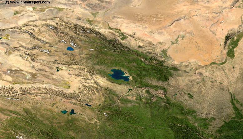
Gansu Province Map 3 - Satellite Map
A Satellite Image based Map of Gansu Province entire and neighboring provinces clearly depicting the natural terrain features that shaped the Province of Gansu in History. Browse around the Image to the outlines of the Gobi & Tengger Deserts, view the Qinghai Plateaux extending from the West providing borders with Gansu Province and Sichuan Province. Central Gansu Province around the Capital of Lanzhou is formed by the Loess Plateaux and the flow valley of the Yellow River (Huang He). Otherwise distinct areas are the Throat of China, Hexi Corridor extending to the North-West and the Ningxia Yellow River Valley, a separate autonomous region and green patch in the North-East.
China Report - Map of China in the Age o/t Han Dynasty 2nd Century BC + Trade Routes
A Schematic Map depicting the Full extends of the Han Dynasty Empire and its trade relations with neighboring States and Neighboring Peoples and Tribes.
Marked on the Map are the locations of Main Cities of the Han Empire, Han Military Garrisons and Strongpoints, locations of Tributary States (mainly in the West) and the Pathways of Sections of the Great Wall of China constructed during the Han Dynasty Reign Era.
Special Links provide access to additional information on each individual site.
Map China Ethno-Linguistic / Language Distribution China
A Full and complete Map of China (PRC) identifying all Language Areas big and small in all Provinces and Autonomous Regions of China.
Map includes Turkic Languages (Uygur, Kazakh, Kirghiz, Salar & Uzbek), Mongolian Language and Sub-Divisions (Mongol, Tu, Daur and Dongxian), Tungusic Peoples (Oroqen, Evenki and Xibe) and Languages, Korean, Tajik (Tadzhik), Mon-Khmer (Kawa + Puman (or Pulang)), Hui, Uygur (Uighur), Tibeto-Bhurman Languages, Tai and Miao, Yao and She' Language Area's and Borders. Main Area's and sub-divisions of Han Languages (Northern Mandarin, Eastern Mandarin, South-Western Mandarin and Cantonese) further included. This color-coded ethno-linguistic Map (of 1967 AD) identifies at a glance most ethnic minority regions in China.
A Full Google Earth Supported Map of Gansu Province by AsiaReport.com.
The China Report introduced on Levels of its Online Publishing's in April of 2009, including Gansu Province.
Find Google Maps on nearly all Report & Photo Pages where appropriate and useful.
Adjacent Map gives direct access to Map Of Gansu Province.
Map Yuan Dynasty Mongol Empire in Time 1206 AD - 1294 AD
A Schematic Map of the Mongol Empire of Genghis Khan (TeMuJin) and descendants through its several stages of conquest in its short but Impressive Existance in History. Timeline depicts the Mongol Conquest starting in the Year 1206 AD, when Genghis Khan first united the Mongol-Turkic Tribes of Mongolia and Lake BayKal becoming Great Khan. The Timeline continous through the year 1219 AD, the year 1223 AD taking Transoxiania, 1227 AD, 1237 AD when the Northern Jin Dynasty of China was annihilated, 1259 AD conquering ancient China above the Jiangste River and 1279 AD when all of China was taken and the Yuan Dynasty Eastablished under the Kublai Khan. Last is the Year 1294 AD when the Mongol Empire reached its largest geographical size and Zenith, 22% of world land area, but through lack of central leadership and over-expansion fragmented into 4 large parts, then imploded upon itself.
Asia Report - Map Trade Routes in Asia in the 13Th Century
A Schematic Map of the Eurasian Trade Routes existing in the 13Th Century. Clearly marked in Red Accent on the Map are the cities of the network of land-bound trading routes through Central Asia known as the Silk Road (the path of Marco Polo and others). Marked in Blue Accent are the Main Ports and Harbors of the Maritime Trade Routes that operated between the Arabian Peninsula and the Red Sea, the Indian Ocean and Coastal Cities, the Straights of Malacca, the South-China Sea's and beyond. As shown Maritime Trade to China mainly entered through Southern Harbors, then was distributed internally by use of the Grand Canal, the Yangste River and the Yellow River.
Map includes the Route travelled by Marco Polo, William of Rubruck and John of Pian de Carpine, the three famed European Travelers of the Time.
Locations of Main Trading Ports and Cities on Trade Routes of the Time are marked.
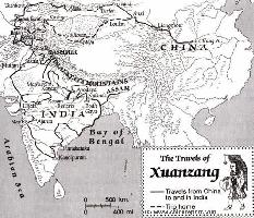
This Schematic Map shows the entire "Journey to the West" as made by the Chinese Monk Xuanzang in the years 629 AD to 645 AD.
The Path of the Journey to India led though China, Kyrgyzstan, Tajikistan, Afghanistan, Pakistan and India. The Return Journey led through Pakistan and Afghanistan to reach Kashgar in current day Xinjiang-Uyghur Autonomous Region of China. Because the (Han) Chinese Cultural Zone during the Tang Dynasty Era only reached as far as Dunhuang, where the Great Wall began, Xuanzang had to travel south-east from Kashgar via Yarkant and Hotien (Khotan) along the South Route around the Taklamakan Desert to finally return to his native China in 645 AD.
Map - Travel Route of Xuanzang - Journey to the West
Schematic Map of the Yellow River Flow Path 01A
A Full Schematic Map of the entire flow path of the Yellow River. Map overviews Qinghai Province, Parts of Sichuan Province, Gansu Province, Ningxia Hui Autonomous Region, parts of the Republic of Mongolia, Inner Mongolia Autonomous Region, Shaanxi Province, Shanxi Province, Henan Province and finally Shandong Province, giving a Full Overview of the length of the Yellow River. Clearly visible details of geographical features such as mountain ranges, rivers, valleys and lakes. The Map includes main cities along the River, popular and famous scenic spots, the dams and water reservoirs on the Huang He and other relevant informations.
Click the links to find more information on each individual location !
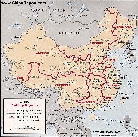
Map China 7 Military Districts (Regional Defense Commands)
Originally thirteen military regions were established in the 1950's, but the number was reduced to eleven in the late 1960's. The resulting eleven military regions - Shenyang, Beijing, Lanzhou, Xinjiang, Jinan, Nanjing, Fuzhou, Guangzhou (including Hainan Island), Wuhan, Chengdu, and Kunming - were reduced to seven intheperiod 1985-88 AD. Currently,the active military districts include Lanzhou- including the former Urumqi MR, part of the Himalayan Mountains in North-West Tibet andAksaiChin, Chengdu Military Region including the former Kunming MR, Nanjing, which includes the former Fuzhou MR, Beijing, and Shenyang. Finally Guangzhou and Jinan Military Regions both appear to include parts of the former Wuhan MR.
The military regions arefurther divided into military districts, usually contiguous with provinces, and military sub-districts.
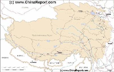
MapTibetHistoricalBorders
A Schematic Map of Historical Tibet, today Tibet Autonomous Region, Qinghai Province and a part of Sichuan province.
Included for reference are current Internationa Borders, provincial borders, locations and names of main cities and towns, main rivers and lakes, mountains,importantTibetan-BuddhistMonasteries and other places of significance.
Further Reports link to More Photos and History & Backgrounds of each City, Town or Ethnic Community of Yugur, Dongxiang Tibetan, Lhoba, Kazakh, Mongol or others where available.
Today Tibet only exists as Tibet Autonomous Region of China. Tourist visits require an aditional visa !
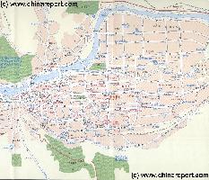
This Schematic overview Map shows the entire "Downtown" or Old City Section of Lanzhou, officially known as the Chengguan District.TheChengguan,astheoriginalcityofLanzhouholdsmostofthehistoricremnantsandalthoughfullofmodernbuildingsandtoweringhighrises,todayisstillthemainculturalcenteroftheCity.
Browse the Map to explore the city and find your way tothe Main landmarks, monuments and hotspots of this part of the City.ClickthelocationsandLinkthroughtomoreInformationandPhotosoneachlocation!
Map - ChengguanDistrict ofLanzhou
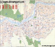
This Schematic overview Map shows the two most important and interesting Districts of Lanzhou, the Chengguan District and the neighboring Qilihe District, West and upstream.TheChengguan,astheoriginalcityofLanzhouholdsmostofthehistoricremnantsandalthoughfullofmodernbuildingsandtoweringhighrises,todayisstillthemainculturalcenteroftheCity. Qilihe is home a more modern section of Town fully integrated with Chengguan and including the Western Railway Station.
Browse the Map to explore the city and find your way tothe Main landmarks, monuments and hotspots of this part of the City.ClickthelocationsandLinkthroughtomoreInformationandPhotosoneachlocation!
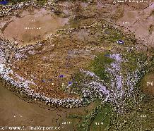
A SatelliteImage overview Map of the entireTibetanPlateauxincluding parts of bordering regions of Xinjiang-UyghurAR, Gansu Province, NingxiaHuiAR, Inner-MongoliaAR,Sichuan Province,andYunnan Province. Surrounding nations and Territories are: Myanmar (Burma), Bhutan, Sikkim, Nepal, Bangladesh, India, Kashmir and Pakistan.
This Map clearly defines Provinces and Regions, main mountain ranges, main rivers & lakes of the region, locations of main cities and landmarks.
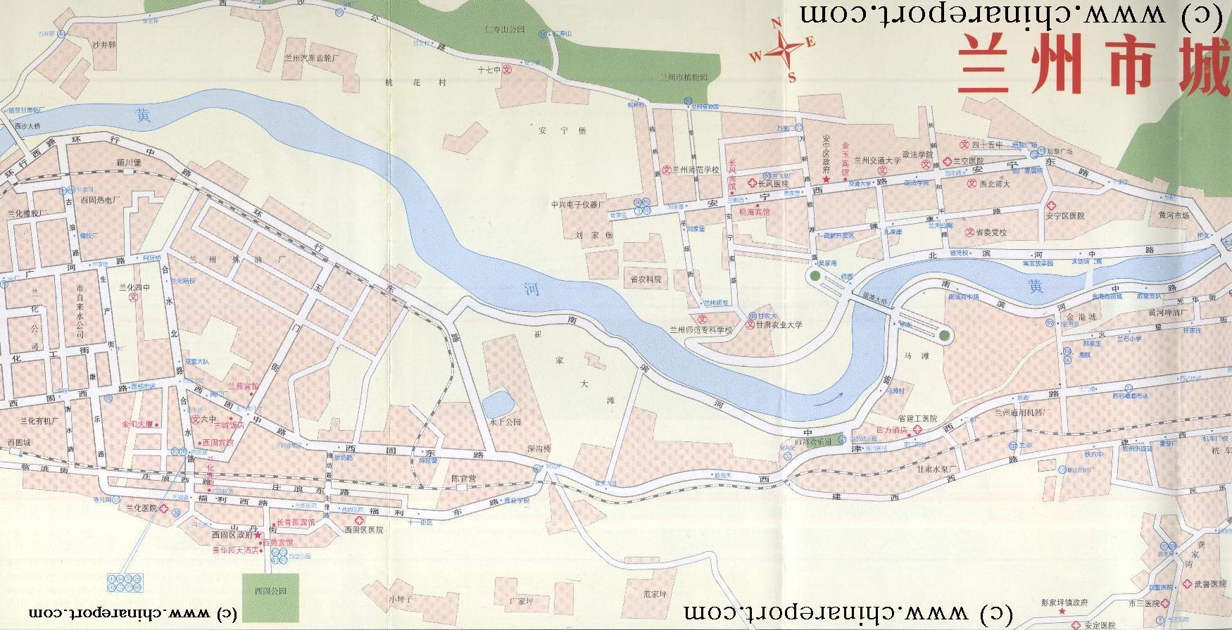
This Schematic overview Map shows the Anning and Xigu Districts of Lanzhou, located upstream from the Downtown Districts ofChengguan and Qilihe.
Browse the Map to explore the city and find your way tothe Main landmarks, monuments and hotspots of this part of the City.ClickthelocationsandLinkthroughtomoreInformationandPhotosoneachlocation!