This page was last updated on: July 24, 2017
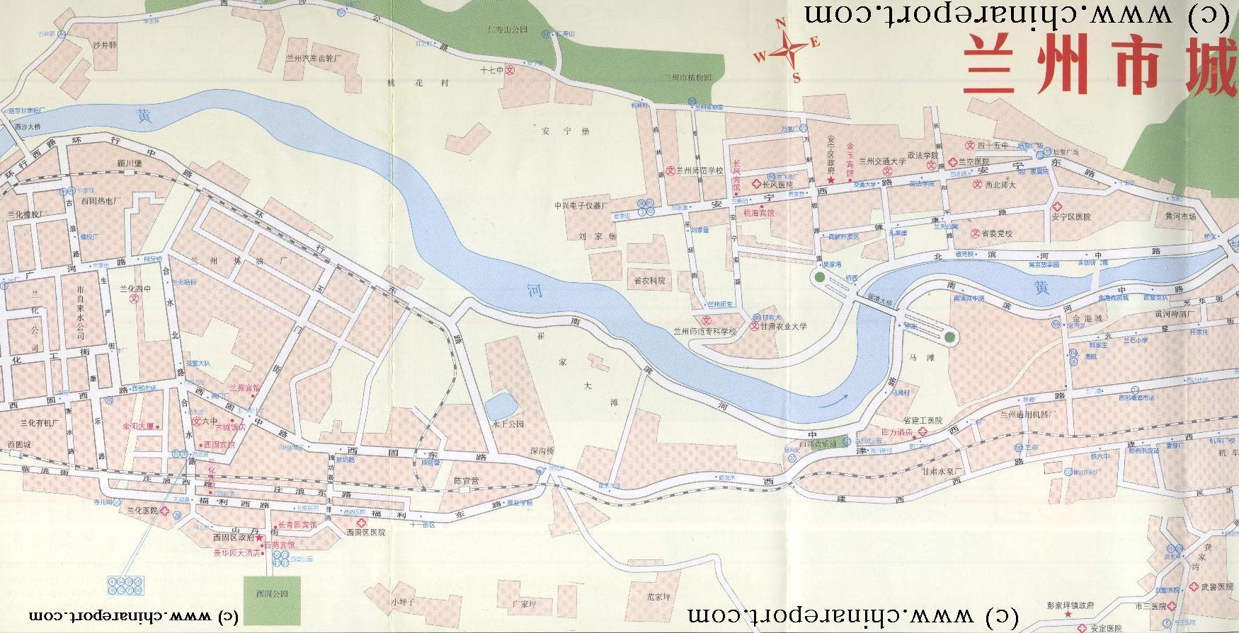
The below Schematic Map Drawing gives a clear overview of the Anning and Xigu Districts of West Lanzhou, The Capital City of Gansu Province. Anning District stretches along the North Bank of the Yellow River and is also known as the 'University District'. The Yellow River passes from West to East between both Districts. Xigu District is located even further upstream from the Downtown Districts (Chengguan & Qilihe) and is also known as the Economic Development Zone. Xigu is the location of railroad yards, oil storage facilties and industrial sprawls. Other parts are reserved for residential blocks.
The Five City Districts are: (Chengguan District (城关区), Qilihe District (七里河区), Xigu District (西固区), Anning District (安宁区) and Honggu District (红古区).

Please Browse around the Map to locate the main Historic Monuments, Landmarks and Hotspots of the City, as well as main Parks, Mountains and Rivers, useful Facilities and other noteworthy Buildings or Structures.
To China Report Main Menu
Lanzhou Maps - Lanzhou Anning (安宁区) District + Xigu (西固区) District - Schematic Overview
Gulang
N-Rd.
Lanzhou
Vocational & Technical College
Electric
Power
School
Lanzhou Electric Power School
Anning E. Rd.
Changxin
Road
Lanzhou Maps Menu - All
Go to www.drben.net webring
ChinaReport.com at
To Main Menu of All Websites at DrBen.Net
The China Report
Jintan
Bridge
Xiuchuan Hotel
Xiao WuTaiShan (2870 Meters) + Monasteries
Marks location of Special Interest Cultural Historic Site
Marks Airport or Train Station
Beijing "Capital" - International Airport
Beijing City
Marks Monument, Landmark and Report
Xiao WuTaiShan (2870 Meters) + Monasteries
Marks Recreational Facility / Tourist Service
- Please browse this Map and follow the Links to Navigate Lanzhou's Anning and Xigu Districts, plus Locations !! -
Yellow
River
Yellow
River
Lanfei Hospital
Xiuchuan
Hotel
Xigu
Oil Storage
Be a 7Search.com Advertiser!
Jintan
Road
RR
Xigu
Park
Renshou Shan
Park
Anning
District
S201
S201
S201
S201 Rd.
Bridge
Huanghe
Shui'An
Garden
Lanzhou
Jiatong Normal
University
Northwest
Normal University
Anning W. Rd.
Lanfei
Hospital
Lanzhou Aeronautical Industry Jigong School
Aeronautical
School
Changfeng Hospital
Lanzhou
Agricultural
University
Lanzhou
City College
Lanzhou Nongye University Hospital
Lanzhou City College
Nongye
Science
Academy
Restaurants
S201
S201
??
Bridge
Gansu Architecture Cailiao Gongye School
Lanzhou
Architecture
School
Water
Park
Shengou
Bao
Park
Tiantan Supermarket
Train Station
Lanzhou Shihua Culture Palace
Fuli E-Rd.
Boya Foreign Language School
Culture
Palace
Xigu E-Rd.
Xigu W-Rd.
Jintain
Hotel
Jintai Hotel
Train
Station
G109
G109
G109
Xijin
Rd.
G109
Xijin Rd.
Hexi
Rd.
G109
Nanbinhe
Md. Rd.
G109
Xijin
W-Rd.
1 Km to To Lanzhou West Railway Station
Police
Donggan 4D Cinema
Yan
Valley
Railroad
Emplacement
500 Meters to Shuidong Gate
Boya Foreign Language School
Cave-well
Gate
(Shuidong)
Water
Treatment
Facility
Oil
Storage
Facility
Overflow
Basin
Industrial
Zone
1 Km to To Lanzhou West Railway Station

View AsiaReport.com - Mastermap of Asia (entire). in a larger map
This page was last updated on: July 24, 2017
My Great Web page
Lanzhou Maps
Lanzhou Transport
Tianshui
Lanzhou History
Lanzhou Landmarks
Lanzhou
Lanzhou Home
Lanzhou Hotels
Tianshui Home
Gansu Sources
Gansu Province
Baiyin Home
Gansu Province Home
China Offline Sources
AsiaReport.com Home
China Report Home
China Online Sources
China Online Store
China Maps
China
China Photo Galleries
China Report Club
Baiyin Prefecture
JiaYuGuan
JiaYuGuan Home
JiuQuan Prefecture
Aksay AC Home
Dunhuang City Home
JiuQuan Home
Dingxi Home
Dingxi Prefecture
Gannan Home
Gannan Prefecture
Jinchang
Jinchang Home
Gansu Economy
Gansu History
Gansu Monuments
Gansu Maps
Gansu Minorities
Yellow River in Gansu
Lanzhou Pref.
Huixian Home
Longnan Prefecture
Pingliang
Pingliang Home
Linxia (Hui) Prf.
Linxia Home
Qingyang
Qingyang Home
Wuwei
Wuwei Home
Zhangye
Zhangye Home