The Mongolia Historic Maps Index gives acces to all Historic Maps relevant to the Republic of the Mongolia, neighboring regions and Area's of Specific Interest within that Mongolia, as used and/or produced by MongoliaReport.com. Please use these Maps to find your way easily around the Nation, Provinces (Aimag), Cities, Area's and many Monuments & Landmarks.
This page was last updated on: August 19, 2017
My Great Web page
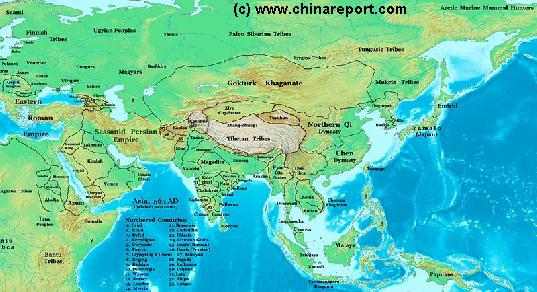
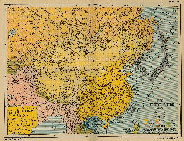
China Report - Map of Ancient Asian Empires and Tribes in Asia 565 AD
An overview Map of Asia Entire clearly demarkating the Territories, Nations and Tribal Area's of the Continent in the year 565 AD. Japan is split between the Yamato Kingdom and Emishi. In Korea three Kingdoms Rule among which the largest Goguryeo. China is split in a Northern Dynasty of the Qi, and a Southern Dynasty of the Chen. While in the Far west the Qi Empire stretches as far West as Dunhuang, the Silk Road is temporarily blocked by the unification of Mongol Tribes in the Gokturk Khanate and the appearance of the smal XiYe City State in the Tarim River Basin.
Asia Report - Map Yuan Dynasty Mongol Empire in Time 1206 AD - 1294 AD
A Schematic Map of the Mongol Empire of Genghis Khan (TeMuJin) and descendants through its several stages of conquest in its short but Impressive Existance in History. Timeline depicts the Mongol Conquest starting in the Year 1206 AD, when Genghis Khan first united the Mongol-Turkic Tribes of Mongolia and Lake BayKal becoming Great Khan. The Timeline continous through the year 1219 AD, the year 1223 AD taking Transoxiania, 1227 AD, 1237 AD when the Northern Jin Dynasty of China was annihilated, 1259 AD conquering ancient China above the Jiangste River and 1279 AD when all of China was taken and the Yuan Dynasty Eastablished under the Kublai Khan. Last is the Year 1294 AD when the Mongol Empire reached its largest geographical size and Zenith, 22% of world land area, but through lack of central leadership and over-expansion fragmented into 4 large parts, then imploded upon itself.
Asia Report - Map Trade Routes in Asia in the 13Th Century
A Schematic Map of the Eurasian Trade Routes existing in the 13Th Century. Clearly marked in Red Accent on the Map are the cities of the network of land-bound trading routes through Central Asia known as the Silk Road (the path of Marco Polo and others). Marked in Blue Accent are the Main Ports and Harbors of the Maritime Trade Routes that operated between the Arabian Peninsula and the Red Sea, the Indian Ocean and Coastal Cities, the Straights of Malacca, the South-China Sea's and beyond. As shown Maritime Trade to China mainly entered through Southern Harbors, then was distributed internally by use of the Grand Canal, the Yangste River and the Yellow River.
Map includes the Route travelled by Marco Polo, William of Rubruck and John of Pian de Carpine, the three famed European Travelers of the Time.
Locations of Main Trading Ports and Cities on Trade Routes of the Time are marked.
Asia Report - Map Yuan Dynasty Mongol Empire in Time 1300 AD - 1405 AD
A Schematic Map of the Mongol Empire of Genghis Khan (TeMuJin) and descendants through its several stages of conquest in its short but Impressive Existance in History. Timeline depicts the Mongol Conquest starting in the Year 1206 AD, when Genghis Khan first united the Mongol-Turkic Tribes of Mongolia and Lake BayKal becoming Great Khan. The Timeline continous through the year 1219 AD, the year 1223 AD taking Transoxiania, 1227 AD, 1237 AD when the Northern Jin Dynasty of China was annihilated, 1259 AD conquering ancient China above the Jiangste River and 1279 AD when all of China was taken and the Yuan Dynasty Established under the Kublai Khan. Last is the Year 1294 AD when the Mongol Empire reached its largest geographical size and Zenith, 22% of world land area, but through lack of central leadership and over-expansion fragmented into 4 large parts, then imploded upon itself.
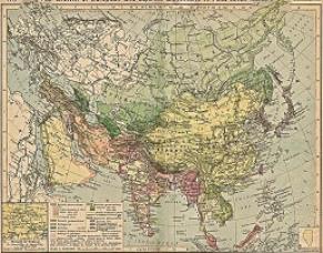
China Report - Colonialism - Growth of Colonies & Japan after 1801 AD
A Map drawing of the Eurasian continent , parts of North-East Africa and the Middle East in the 19Th Century between 1801 AD and 1900 AD. Focal points are the expansion of western colonial posessions of Portugal, Britain and France, as well as Russia moving from West to East. Labeled separately is the later Rise of the Empire of Japan in the East.
Included in this Map are the main cities across the continent with their brief histories and events during the 19Th Century. Marked in Colors for clarity are the various colonial and imperialist Nations. As relating to China; special attention is payed to so called Treaty Ports. The First Treaty Ports were forced open by Britain in the year 1841 AD, but counted over 80 in total by the end of the 19Th Century. The most important Treaty Ports in China are marked and described with a short history where the map allows. Follow the links for more information on each location and subject.
China Report - Historic Map - China (Qing) Empire in 1910 AD
An obviously non-Chinese but western-made Map of the Qing Dynasty Chinese Empire in the year 1910 AD, a year in which China's sovereignty has been under threat and siege for over 70 years.
In this Map of 1910 AD, made one year before the abdication of Last Ching Emperor Xuan Tung (a.k.a. Aisin-Gioro Pu Yi) and the final end of China's Feudal History, China is depicted as in its smallest boundaries and definition. Most notably Manchuria, and Inner Mongolia, both territories nominally under Chinese Control and under Chinese Sovereignty are depicted as separate area's.
Other interesting features of the Map and geography of the Time : after the Sino-Japanese war of 1899 AD, both Korea and the Island of Formosa (now Taiwan / ROC) have been annexed by the Japanese Empire.
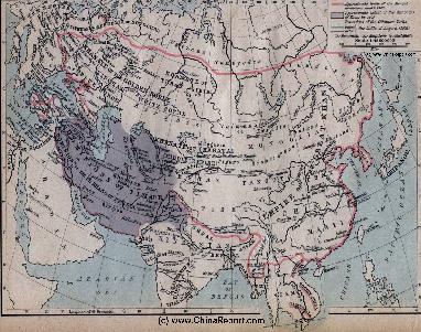
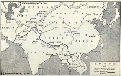
MapHistory - Schematic Asia - Russia China Britain Great Game 1900 AD
A Schematic Map of Historical East Asia at around the year 1900 AD and the turn into the 20Th Century.
Although the Manchu ruled Qing Dynasty Empire had previously conquered large parts of East Asia, including much of Korea, parts of current day Siberia, most of Mongolia, East Turkestan, Kyrgyz, Kazakhs and other tribal lands while subjecting Tibet to a subjugary role nominally ruled for its taxes but yet remote and inaccessible behind its mountainous walls, at the turn of the 20th Century the outer regions of the Qing Empire have been eroded away, much of the north and west increasingly under Russian control while in the south and along the coast Britons and others had fought their way into the Chinese Realm. Notably, Korea has been annexed by Japan and Tibet is shown as a de facto independent territory. Tibet will be invaded by Britain in 1901 AD and will declare Independence not long there after at the fall of
the Manchu Dynasty and the end of Manchu rule over China but also Mongolia and Manchuria in 1911 AD. Other groups such as Mongolians, Kazakhe and Kyrgyz will likewise attempt to reestablish their National independence after the fall of the Manchu Empire.
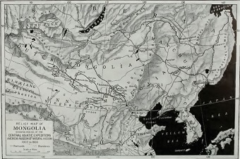
Mongolia Report - Historic Map Roy Chapman Andrews Expeditions 1922/30
A hand drawn Map from the hand of Roy Chapman Andrews depicting the various routes and locations relevant to his expeditions in East Asia between the years 1922 and 1930.
Map depicts north east Asia focussing on Inner- and Outer Mongolia. Map further the Tuva Republic, Irkutsk Oblast, the Trans-Baikal Region, Manchuria and the Russian Primorsky Krai Maritime Province. Other notable features are the Korean Peninsula, parts of north China, the Kokonor Region of the (then) independent Nation of Tibet, and the East Turkestan Republic or Territories (Xinjiang), at the time in disarray and under heavy Russian (Soviet and other) influence.
Click the Buttons and follow the Links to more information on each location and subject.