This page was last updated on: October 8, 2017
Schematic Map of the Qing Dynasty Manchu Empire in the year 1910 AD, a year in which its sovereignty had been under threat and siege for over 70 years. On the Map one can make out how the the Manchu Qing Dynasty Empire found itself encircled by the rising Russian Empire in the north, and attacked, knawed at and invaded by the British Empire in the south west and all along the Coastal Regions (with other Foreign Powers joining in).

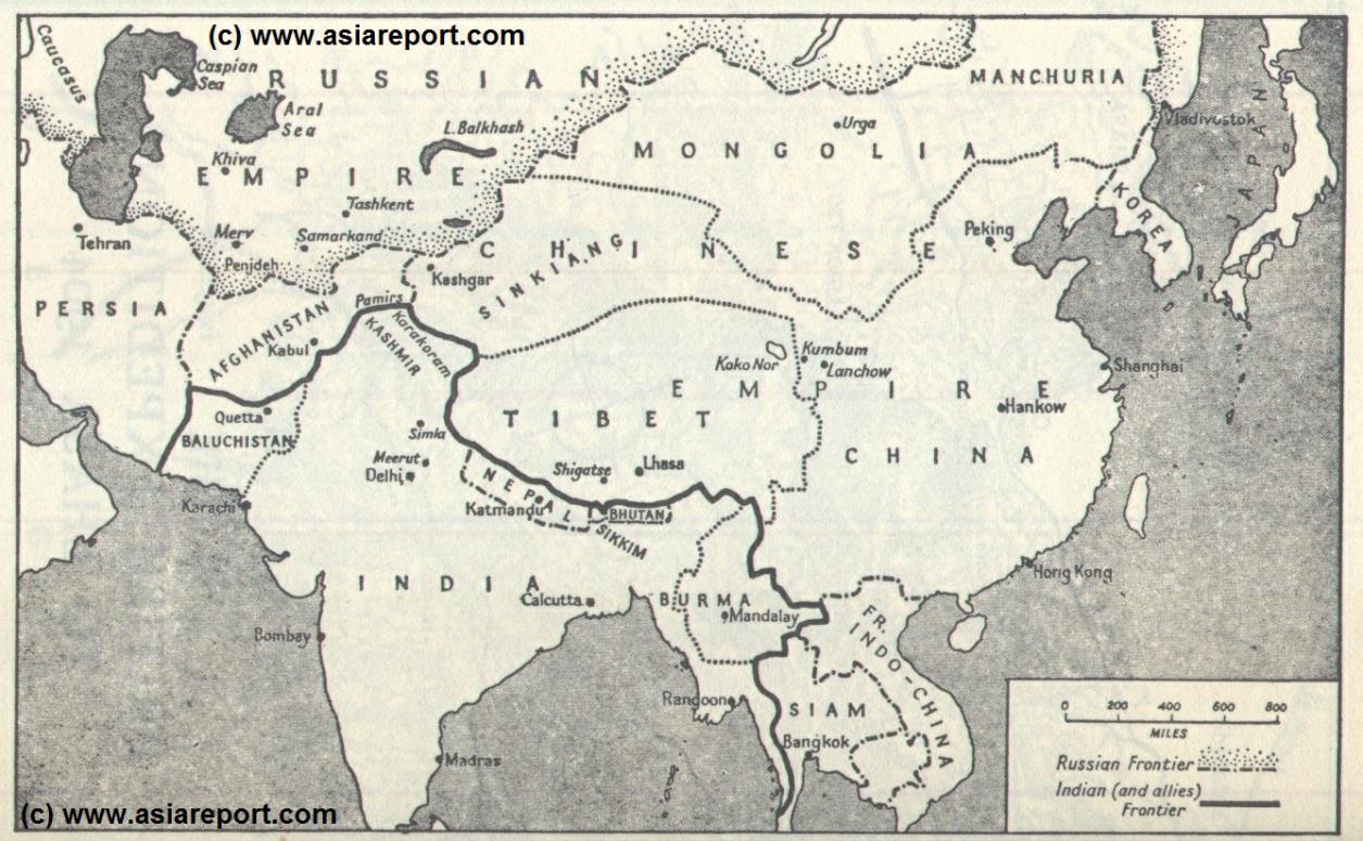
In this Map of the situation as it presented itself around the year 1900 AD, after the Japanese annexation of Korea but some 10 years before the final end of China's Feudal History, China is depicted more or less its smallest boundaries and definition. Most notably Manchuria (currently Liaoning, Jilin and Heilongjiang Provinces), and Inner Mongolia, both territories nominally under Chinese Control and under Chinese Sovereignty are depicted as separate area's.
Altogether special interest may be payed to Mongolian inhabited regions of the once great Qing Empire, which are shown here as continuous with Manchuria but not a part of China proper. At the same time Western Territories of the Manchu Empire ("Chinese" Turkestan) aka Xinjiang are depicted as connected and continuous with the Chinese heartland, yet the Altay in the north of current day Xinjiang as well as Dzungaria are (already) counted as part of the Russian Empire.
As for Tibet, although it has been invaded by British and Indian forces in 1901, in a few years Tibet is only nominally under the control of the Manchurian Qing Dynasty, and soon will declare independence). The Mongolian grasslands, The Manchurian Hills and the large large and mineral rich strategic regions of Chinese Turkestan and Tibet were equally under interest of outside Parties Japan and Russia and India-Britain and already under dispute long before the year 1900 AD.

Clearly marked are the so called "Treaty Ports", which were sea and later river harbors that were forcably opened under treaties forced on China after crushing defeats in the "Opium Wars" 1840 AD and 1860 AD. Although they cannot all be shown on this Map, some of the main strongpoints of Imperialist Powers have been marked on the Map for reference and in order to show more of the extend of encirclement of the Manchu Qing Empire which included all of China.
Other interesting features of the Map and geography of the Time : after the Sino-Japanese war of 1895 AD, both Korea (1910 AD official) and the Island of Formosa (now Taiwan / ROC) have been annexed by the Japanese Empire.
The China Report
Map Asia - History - Schematic: Great Game in Asia (Russia, Britain, Manchu Empire) 1900
Yinchuan
Zhongwei
Wuwei
Xining
Saigon
Xiamen
Nanjing
Guiyang
Wuhan
Nanning
Guangzhou
Chongqing
Chengdu
Xi'An
Osaka
Kyoto
Nagasaki
Sapporo
Tokyo
Hanoi
Yunnan Fu
Changsha
Fuzhou
Kelung
Ningbo
Qingdao
PyongYang (Japanese annexed Korea - 1910 AD)
Seoul
Fusan
Datong
Turfan
Uliastai
Khotan
Khovd
Jiayuguan
Urumqi
Dunhuang
Kumul
Kulja
Shenyang
(Mukden)
Irkutsk
Teng
-ger
Wuwei (Gansu Province)
Fujien
Shanghai - International Treaty Port (1842)
Datong, Shanxi Province
Lhasa, Tibet
Xi'An (Shaanxi Province)
Hong Kong (Island) - British Island Colony + Treaty Port - Leased until 1999 AD
Mandalay
Shigatse, Tibet
Kelung (now Taipei, Taiwan) - Japanese Annexation
Rangoon (British)
Map of Same Area - Rise of European Colonialism in Asia 17Th Century
Tokyo (Japan)
Kyoto (Japan)
Nagasaki-Deshima Island (Dutch)
Pondicherry (French)
Calcutta (British)
Macau - Portugese Treaty Port
WeiHe Wei (British leased Port)
ChinaReport.com at
To Main Menu of All Websites at DrBen.Net
Go to www.drben.net webring
Hanoi - French Protectorate
Bombay (British)
TianJin - International Treaty Port (1860 AD)
Ning Xia Fu (Ningxia Province)
Port Arthur (Dalian) - International Treaty Port
Foochow (FuZhou) - International Treaty Port (1842)
Amoy (XiaMen) - International Treaty Port (1842)
Ningpo (NingBo) - International Treaty Port (1842)
Fusan (Japanese annexed Korea)
Seoul (Japanese annexed Korea 1910 AD)
Nan King (Nanjing)
Wuhan
Hanchow (Hankou) - International Treaty Port (1858)
ChungKing (ChongQing)
Yunnan Fu (Yunnan)
Darjeeling (Sikkim - British India)
Kathmandu (Nepal - British Controlled)
Lanzhou (Gansu Province)
Xining (Qinghai Province)
Dunhuang (Gansu Province)
JiaYuGuan (Gansu Province)
Beijing
Heilong
jiang
Kashgar or Kashi (Chinese Turkestan)
Hainan
Guangdong
Kiao-Chow + TsingTao - German Leased Port
Ordos
Guangzhou(Canton) - Chinese Trading Port
Mukden or Fengtian (Shenyang) - International Railway City
Guiyang (Guizhou Province)
Changsha (Hunan Province)
Cheng Tu Fu (Today-Chengdu, Sichuan Province)
Nanning (Nanning, Guangxi Zhuang AR)
Urumtsi (Urumqi, Chinese Turkestan)
Yunnan
Sichuan
Guizhou
Kulja (Yining, Ili-Kazakh, Chinese Turkestan)
Hotan or Khotan (Hetien, Ili-Kazakh, Chinese Turkestan)
Keriya, (Yutien, Chinese Turkestan)
Cherchen, (Cherchen, Chinese Turkestan)
Turpan (Turfan, Chinese Turkestan)
Aksu (Chinese Turkestan)
Hami (Kumul, Chinese Turkestan)
Krasnoyarsk, Russia.
Omsk, Russia.
Irkutsk, Russia.
Vladivostok, Russia.
Semipalatinsk, Russia.
Khovd, also: Khobdo or Kobdo, Capital of Khovd Aimag, Republic of Mongolia.
Uliastai, Capital of Dzavkhan Aimag, Republic of Mongolia.
Fukuoka (Japan)
Osaka (Japan)
Jiangsu
Delhi (India - British Controlled)
Find DrBen and ChinaReport on Facebook with the latest from www.drben.net.
DrBen Nijhoff | Maak je eigen badge
Enter the Territory of Tibet ...
Baidan Jairan
BURYATIA
BURYATIA
Urga, also: Ulaanbataar, Capital of the Republic of Mongolia.
Taiyuan
Karachi (British)
Kabul (Afghanistan)
Quetta (Pakistan)
Tehran (Iran)
Madras (India)
Sapporo (Japan)
Taiyuan, Capital of Shanxi Province
Saigon - French Protectorate
BURYATIA
Trans Baykal
Dzungaria
Altay
Altay
Gobi
Gobi
Takla
Amakan
Amdo
Kham
U-Tsang
China Maps
Satellite Maps
China Online Sources
China Offline Sources
China Online Store
Art & Culture
History
China News
China Travel
DrBen.net Home
China Provinces /Home
China
AsiaReport.com Home
Asia
China Report Club
Blog
Twitter
Forum
Chat
DrBen Live TV
China Video Library
China Photo Library
China Politics
Provinces Maps
City + Site Maps
Historic Maps
AsiaMaps.com Index
Tashkent, Uzbekistan.
Samarkand, Uzbekistan.