Apart from the Shanhai Pass of the Great Wall itself, the defenses of the vital pass include two additional sections. Firstly there is the Old Dragon's Head and the attached Great Wall of China (the only part of the Great Wall that meets the sea) closing the gap between Shanhai Guan Pass Gate and the Sea in the East, and secondly there are the Jiashan Mountain due west of the City of Qinhuangdao, which are the first sections of the Great Wall of China to climb from the north China plain into mountains of Hebei Province).
Arranged together as they are, the Shanhai Pass and fortifications themselves are erected as a barrier between the North-Eastern (Dongbei) plains (of Manchuria) and the North China (Huaibei) plain in which the City of Beijing is situated. To complete the defenses on the an even larger scale, the Great Wall built in the Ming Dynasty Era (1368 A.D. - 1644 A.D.) leads from Shanhai Pass eatward to Mount Yan (Yan Shan), where it splits into two parts. The Southern part is considered as the Main Body of the Great Wall of China and leads south and west past Qian'An City, Zhunhua City into Beijing City Province where it continues to Miyun and Huairou. The Northern part of the split at Yan Mountain is considered an addition, but still reaches a fenomenal length. The Northern Wall curves north into Shuizong Prefecture
- Old Dragon's Head (Laolongtou) Great Wall-
This page was last updated: May 20, 2017
Great Wall of China in Hebei Province
ChinaReport.comat
The Great Song Era historian Ouyang Xiu 1007 AD - 1072 AD) once wrote on the Matter of the continuous raids by Nomadic Tribes against Han Chinese Communities; "Our Chinese Infantry Men are at their Best (in war) in obstructing Passes, while the Barbarian Cavalry is at its Best on the Flat land. Therefor, let us resolutely stand guard on the Passes, and let us not drive after them in pursuit or in order to get rid of them. At the Time when they come, we should close and defend the passes so that they cannot enter (our lands). When they leave we should close strategic passes (as well) so they cannot return".
And so it was done. Although in the Song Era only modest defenses on scattered passes on the Northern borders had been erected, during the Ming Era the Great Wall would finally become one unified defensive system.
Shanhai Guan Guan Pass o/t Great Wall depicted on Stamp valued 20 Fen.
Soundbonus: Chinese Folk Classic "The Great Wave crashes (on) the Beach", traditional Chinese Pipa Music by Liu Fang.
A Full Google Earth Supported Map of ShanhaiGuan Fortress City by Google.com.
SHANHAI PASS AND GREAT WALL IN THE SINO-JAPANESE WAR:
After lenghty battles had already been fought out between Japanese Armies and the Kuomintang and Communist Party Volunteers during 1932 AD, in 1933 AD the Japanese Army, bent on including the Chinese Territory of Rehe (parts of Hebei, Liaoning and Inner Mongolia AR today), attacked the Shanhai (Guan) Pass. The attack was initially repelled by the Chinese Garrison ready on the Great Wall and inside the Fortress, however eventually the Japanese beat them back suffering heavy casualties. After the taking of the Shanhai Pass in 1933 AD, the Japanese Army could move on to include Rehe, and encircle the strategically important Northern Capital of Beiping (Beijing). Although the battle for Rehe would last 3 months longer, seeing 20.000 Chinese soldiers dead, the Chinese Lines crumbled under the efficiency of the Japanese attacking force.
Next up were the Great Wall of China passes on direct approaches to Beijing in Eastern Rehe. More battles at the Great Wall of Jiumenkou and Jifengkou (Xifengkou) between the Japanese Imperial Army and the 29Th Route Army of the Chinese Communist Party.
Both Xifengkou and Luowenyu (in Hebei province) were vital passes on the road to Beijing and commander Song Zheyuan was responsible for the village of Lingzikou, both passes and the distance to the village of Malanyu.
On March 10 and 11 1933 AD bloody hand to hand combat took place on both passes between eager Japanese invaders and equally zealous Chinese Communist Volunteers. Both sides intermixed, hacking away at eachother with broad swords. Meanwhile Japanese artillery and aircraft supporting the infantry attack were unable to intervene. The attack faltered with the Japanese retreating in surprise.
The very next night on March the 11Th, a small Chinse Group challenged the cold night and the falling snow to raid the Japanese soldiers in their own camp. In the early hours of the 12Th of march, the raiding group found a Japanese Artillery camp where the soldiers of the 14Th Group were sound asleep. A deadly mistake of the overconfident Japanese Force.
A battle ensued throughout the night, with both sides sending in reinforcements. In the morning 18 pieces of artillery were destroyed and some 600 Japanese Soldiers lay dead.
China Report - Map of the Great Wall during the Ming Dynasty
Satellite image of China and North-East Asia, with a super-imposed schematic Map of the location and Path of the Great Wall as constructed during the Reign of the Ming Dynasty. Included for reference are City names, geographical features of landscape, Names and locations of Passes on the Great Wall of China.
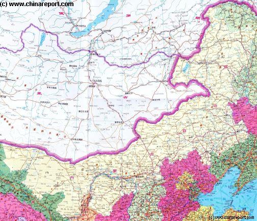
Helpful Geographic Map of Inner-Mongolia showing the larger geographic relations in the Region. importance and pathway of the railroad Baotou Connection.
Gate, Gate Fortress and City, and then there are the mountains.
Although belonging to the same large scale defensive works inside the narrow gap between the Sea and the Mountains, each section lies several kilometers from the other, and each section has distinct caracteristics, making all of them quite different and wortwhile to visit seperately. This page and chapter deals exclusively with the Shanhai Pass (Shanhai Guan) and the Shanhai Pass Gate Fortress and City.
The other sections are described seperately. These are: Old Dragon's Head (Laolongtou) and its Wall in the East, and the Jiashan Sections in the West.
of Liaoning Province as the Jiumenkou Great Wall. From there the Wall follows along the border with Inner-Mongolia Autonomous Region past Yixian, Haicheng, Liaoyang and Shenyang. North of Shenyang the "Northern Wall" continues heading towards the Korean Peninsula where it ends today at the Tiger Mountain (Hu Shan) just north of the City of Dandong on the North Korean border. The original Wall however, reached even further, into North Korea to include all of the City of Pyongyang - a Chinese enclave and protectorate until the dying years of the Qing Dynasty (1368 A.D. - 1644 A.D.). In recent years many ruins been found indicating further walls in and near Korea.
Returning to the Great Wall of Shanhai Pass on the coast: The Great Wall of China at Shanhai Pass (Shanhai Guan) is one of the most famous Gates on the Great Wall, for many reasons but most likely for the Chinese-Mongol showdown that occured at the Gate of the Pass when the armies of Genghis Khan arrived bent on Invasion.
It has also been called the museum of the construction of the Great Wall because of the great variety found in the Ming Dynasty Era defenses of this section. There are the Wall and the Sea, the
Find DrBen and ChinaReport on Facebook with the latest from www.drben.net.
Four days later on March 16Th the Japanese re-attacked at Luowenyu, attempting to zeize the strategic Sanchakou Hill. Being held back, on the 17Th the Japanese Air Force arrived and a full offensive combining air assaults and artillery attacks followed. Again the Chinese strategy was to let the Japanese come in close so they would lose their artillery and air support. Hand to hand combat on and around the Wall ensued throughout the day until darkness fell.
The next day on the 18Th the scenes repeated themselves.
In the night however, the Chinese Armies again counter attacked. This time Chinese forces surrounded the Japanese Camp-sites and annihilated them in a final lenghty battle.
So, the Chinese side won. In fact, it advanced 10 kilometers in the next few days, gaining back Chinese Territory. A new Treaty. The Tanggu Treaty, with the Central Government however effectively ended all battles, tacidly approving of Japanese control of Rehe and other parts of North China.
A Full Google Earth Supported Map Overview of All Structures of the Great Wall of China from East to West, by DrBen.Net (c) ChinaReport.com and Google.com.