A Full Google Earth Supported Map of Taolinkou Great Wall by Google.com.
The China Report introduced on Levels of its Online Publishing's in April of 2009, including The Great Wall of China.
Adjacent Map gives direct access to Taolinkou Wall Map by Google Earth.
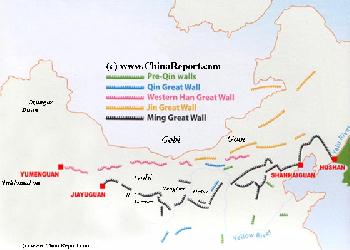
Map Great Wall China - Layers of Dynasties and Historic Era's
A Schematic Map of China and East-Asia, with a super-imposed schematic of the various layers of the Great Wall of China.
Features Pre-Qin Dynasty Wall, Qin Dynasty Wall, Western Han Great Wall of China, the (Northern) Jin Dynasty Great Wall and finally the Ming Dynasty Great Wall as mainly remains today.
Main Features are Names and locations location of Passes on the Great Wall of China, outer layer and inner layer. Includes Shanhai Pass, Huangya Guan (Yellow Cliff) Pass, JiYunGuan Pass, Ningwu Guan Pass, Pingxin Guan, YaMen Guan Pass, Pian Guan Pass, JiaYuGuan pass, YuMen Guan Pass (Jade Gate) and Yang Guan Pass.
Further included for reference are City names, geographical features of landscape and main mountain ranges. Updates occur several times a year adding new pass locations and photo-virtual tours of Passes throughout China.
A Full Google Earth Supported Map Overview of All Structures of the Great Wall of China from East to West, by DrBen.Net (c) ChinaReport.com and Google.com.
Due to its submergence underneath the waters of a modern day dam reservoir the Great Wall of Taolinkou has become one of the unique sections of the Great Wall. Eversince 1979, and especially with the progression of China's opening up to the outside world many short artciles have been written and published. Today's Taolinkou Great Wall is an off the beaten path destination for Great Wall tourists looking for the "real experience", which basicly means: hiking along an unrestored section of the Great Wall, while enjoying the views of nature and the untouched scenery of the Chinese country-side.
Eventhough difficult to access and reach, Taolinkou sees plenty of visiting tourist, most of whom come out to hike during the spring and summer season.
Scout out the remains of the Pass City of Taolinkou including the broken remains of the South Gate. There are three watchtowers situated on the steep mountain lying due south-east of the Village. The terrain east of Taolinkou is precipitous, with a main peak that measures 615.7 meters in height.
There are lots of small hotels in Taolinkou, so it would be the perfect place for a weekend trip.
An additional attraction is the Taolinkou scenic Area. The scenicc area measures a total surface area of 260,000 acres, including the lake which itself is more than 60,000 acres. With the the Taolinkou Hyrdo/electric dam as its the scenic center, the great wall in view and the surroundings of a natural landscape it is a fairly popular local destination and pleasure spot. Activities go on all year around, with ice skating and fishing in winter, abundant fruit flowers in spring, rafting and boating in summer and the picking of fruits in the late summer season. The Dam itself has been turned into a tourist attraction as well, featuring a Museum with exhibition hall featuring photos and explanations of hydropower plants as well as displays and more information on the underwater Great Wall sections (some dating to the Qi Dynasty Era).
importance. In due time, the fortified Pass at Taolinkou was attacked several times by large Mongolian armies, and failed on a number of occassions. As a result of this, in the later period of the Ming Dynasty Taolinkou and Pass were united into one large defense complex, and the Town of Taolinkou became a full Pass City, meaning a fortified border town that was fully integrated with the structures of the Great Wall of China. Hence, today many ruined sites dating to the Ming Era can be found in town and its wider vicinity. Standing on the Qinglong River banks one can clearly make out the ruined wall sections and follow the main wall which passes along the East side of Town and can be seen climbing and winding along mountain ridges and tops in 3 directions.
Although still considered as a very remote, or at least inaccessible section of the Great Wall of China, Taolinkou Great Wall offers plenty of stiff but enjoyable hikes. Not only are there the ruined walls and gates of Taolinkou Town, which was spaced into 3 conjoining fortresses, the hills and mountains around offer miles of ruined walls and a variety of fairly well surviving watchtowers to explore.
Taolinkou Town itself is quite popular among native Chinese Tourists and offers plenty of hotel and hostel space. Getting there is the main problem.
The first Great Wall of China crossing the gap of the Taolin Pass was constructed during the Qi Dynasty Era (479 A.D. - 577 A.D.).
In the Ming Dynasty Era, Taolinkou was one of the passes that was frequently attacked by Mongolian Armies and several times in history, they managed to break through, entering into the Central Plains to
loot, kill, pillage, burn and rape.
Historic records reveal that one such a large scale incursion of Han Chinese lands occured in the 11th year of the Zhengde reign period (1506 A.D. - 1522 A.D.). However, with a strong and decisive commander in chief in Charge, one Zhang Shen, this attack was succesfully repulsed by the Chinese Troops, eventually driving the Mongolians back to the plains.
For half a century things remained relatively quiet at Taolinkou until the Mongolians, now stronger, more numerous and better organized returned to lap up against the Chinese defenses. In this round the Mongolians were more succesful.
In the Wanji reign period (1573 A.D. - 1620 A.D.) alone, no less than four massive Mongolian invasions were recorded, the break through of the armies putting the Capital Beijing in immediate jeopardy. This was quite clearly an intolerable and dangerous situation. In response, after the succesful Mongol Campaigns and their retreat, the defenses at Taolinkou were enhanced, expanded and upgraded, in due time turning Taolinkou into a one large fortified pass, and the Village of Taolinkou into what is known as a Pass City.
Thus, in the last decennia of the Ming Dynasty Era, the Peach Forest Pass (Taolin kou) ranked among the top 5 of most protected passes along the Great Wall of China.
The Great Wall of China at Taolinkou is situated in the Qinhuangdao Prefecture of Hebei Province not too far from the Taolinkou reservoir. To be more exact, the Taolinkou Reservoir lies at some 100 kilometers (62 miles) east of Beijing and the Taolinkou Great Wall is set 34 kilometers due north of Jujong Town, the administrative center of Jujong County. The town and Great Wall are situated along the Qinglong He, an important river that flows roughly from north to south cutting through the Great Wall of China.
The Wall at Taolinkou (桃林口), meaning Peach Forest Pass, was first constructed during the Qi Dynasty Era (479 A.D. - 577 A.D.) when the Pass of the Qinlong River first gained strategic importance. However most of the ruins found scattered around Taolinkou Town today date to the much later Ming Dynasty Era (1368 A.D. - 1644 A.D.). Today's Taolinkou Great Wall therefor is a ruined section of the Ming Dynasty Era Great Wall of China and is constructed entirely of mud and brick.
During the Rule of the Ming over China, the Imperial Capital had been moved to the northern city of Beijing (Bei Ping = Northern Capital) raising the Village of Taolinkou on the ladder of strategic
This page was last updated on: May 20, 2017
My Great Web page
As with the entire stretch of the Great Wall of China between Shanhaiguan in the East and Juyong Pass (Badaling) north-west of Beijing the Great Wall at Taolinkou was constructed according to the design of Qi Jiguang (See also: Structures of the Great Wall - Fighting Platforms and Watchtowers). This is also known as the Beijing-Tianjin-Hebei Great Wall due to its uniformity in design.
After successfully solving the longstanding problem of Japanese Raiders on the southern and south-eastern coast (a by effect of an Imperial Ban on Chinese sea-born trade and exploration ending the Zheng He Missions), Qi Jiguang was assigned to the crucial north-eastern defensive ring of the Great Wall surrounding Beijing, the Capital. His duties as Commander in Chief of Jizhou Town (the entire border district), taken on in the year 1568 A.D. , made him responsible for design, strategy and operations of the Wall. After observing procedures along the Wall for a while, Qi susbsequently came up with a new miltary strategy which was adapted better to the terrain along the Great Wall, developed an improved design for the watchtowers and oversaw the wholesale rearranging, construction and improvement of defenses along the north-western frontier including Taolinkou. Altogether, Qi Jiguang and the troops assigned to the sector (Jizhou Town) spent a total of 5 years nearly rebuilding the entire Great Wall completing the whole just in time as within a few years of his appointment new and even larger hostile northern armies would attempt to break into the Great Wall and threaten the nations Capital.
As described, in the Wali Reign Period for seperate assaults on the Great Wall occured with at least one leading to a partial penetration of the Great Wall defenses. Additional fortifications were built within the pass and around Taolinkou Town at a later time.
China Report - Map of the Great Wall during the Ming Dynasty
Satellite image of China and North-East Asia, with a super-imposed schematic Map of the location and Path of the Great Wall as constructed during the Reign of the Ming Dynasty. Included for reference are City names, geographical features of landscape, Names and locations of Passes on the Great Wall of China.
To give a rough idea of how the defenses at Taolinkou Pass were organized: The Peach Forest Pass Fortress was made up of several components. Not only was there a Pass Fortress built across the narrowest opening of the Pass, set a short distance back inside the Pass were three more fortified area's which could be dubbed the front, middle and back fortress.
In addition, the lower end of the Pass was protected by yet another Castle, which ensured that the Pass and its garrison could not be easily be outflanked and attacked from the rear.
The function of Taolinkou Town as a Fortified Town, was thus mainly a military one. The majority of the population of the Town in the Ming Dynasty Era must have consisted of soldiers, although there must have been plenty of civilians living among them, doing trade, chores and farming.
A number of military barracks were positioned within the Fortified Pass, one to serve the Taolinkou Pass Fortress, and another two inside of Taolinkou Fortified Town. To complete things an excercise field for the soldiers was arranged outside the Taolinkou Pass, just north of the Pass Fortress.
Except for its status as Pass City, the Taolin Pass (Taolin Kou or Gou) was famous in the Ming Dynasty for having an arched bridge that spanned the river Qinglong. Built across at the narrowest point of the Pass, this was still a substantial achievement which was duely noted. Not only was the Qinglong a wide river, its waters are fast flowing in the high season and can become a dangerous torrent. As is noted on a Stele bearing inscription found at Shangzhuang Village inside the Taolin Pass a bridge tower called Qiaotai was erected on that side of the river in the the year 1586 A.D., which was the 14th year of the Wanli reign period of the Ming Dynasty. The stele is inscribed with the words (in translation) "The Bridgehead at the New River Mouth of Taolinkou". When the full bridge (Qiao) was complete it held a platform of the Great Wall of China on it, which thus spanned across the river to continue unbroken to the other side of the Pass. This was a unique construction which was not duplicated anywhere along the entire length of the Great Wall of China in any era.
Not much is known about the history of the Taolinkou Great Wall after the demise of the Ming Dynasty in the year 1644 A.D. During the following centuries, under the Rule of the Manchu Qing Dynasty (1644 A.D. - 1910 A.D.) China was united with Manchuria and the Great Wall lost its usefulness, reverting Taolinkou Town back onto its original position, that of a minor farming village set along a remote and difficult to reach pass into more northern regions. With better routes available (for instance, the main road to Shenyang, at the time the Capital of Manchuria, runs more to the East through Shanhai Guan) Taolinkou was soon forgotten.
Although famous in history, having lost most of its status and rarely visited by outsiders in the 19Th and 20Th Century, Taolinkou was left to see its majestic wall slowly crumpling.
It was only in the year 1979 that Taolinkou briefly came into the news when it was decided to go ahead with the construction a hydro-electric dam across the Qinlong River creating Taolinkou Reservoir as part of a project by Qinhuangdao City to draw water from the Qinglong River. What did not make the International News was the fact that due to this news villagers throughout Lulong County and in Taolinkou mistakenly came to believe that all of the Great Wall would be submerged in the coming years. In the months thereafter the Taolinkou Great Wall sections were greatly damaged by farmers and villagers coming to demolish the Great Wall and using the bricks to build a new home, or some other structure needed (in late 1976 the Tangshan Earthquake had leveled or damaged many homes in the wider regions including in the Capital Beijing). Very serious damage was done to all Great Wall of China Sections in the Tangshan Prefecture and in according to the Great Wall Society, the most serious damage was done to the Great Wall section at Taolinkou village. Much later, in the 1990´s it was recorded that of the 397 households in the village, 70% lived in houses built of bricks derived from the Great Wall of China.
When this sissue was finally exposed in the national media Taolinkou was described as the village with 'the world's most expensive houses'.
Between 1992 and 1997, 23,000 Chinese farmers were resettled in Tangshan prefecture of Hebei Province to make way for the Taolinkou reservoir. Eversince its creation, Taolinkou has been changed forever. That is, a large part of outer town of Taolinkou was submerged as a result of the rising of the waters behind the dam. A large section of the crumpling Great Wall of China was also offered up to progress.
In the year 2006 Taolinkou village suddenly become a model village for protecting the Great Wall. In a late response to the earlier media row and according bad reputation of Taolinkou the villagers countered by putting up what they dubbed a 'sense of shame monument in the village square' and displaying their 180 degree turn about on the matter of the Great Wall and its protection. Since this time locals and farmers take shifts in the 'inspection and supervising' of the hiking routes the Great Wall. This 'neighborhood watch' approach to conserving the remaining great wall is not limited to Taolinkou village but has since been expanded to Yanchi in Ningxia, Yanqing County, the Great Wall north of Beijing, Shek Kip Village, and other places. Long after the first introduction of the Government sanctioned Great Wall Protection Ordinance, Chinese people realize what it means to really protect the Great Wall.
VILLAGES NEAREST THE TAOLINKOU GREAT WALL of CHINA
Liu-chia-ying: 5.99 km west
Yanheying: 7.91 km south east
P'an-chuang: 9.45 km south west
Sanchakou: 10.18 km north east
Caonian: 11.91 km north
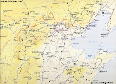
Map - Schematic - Hebei-Beijing-Tianjin Great Wall Locations
A Schematic Map overview of Great Wall locations and sections in Shanxi Province, Hebei Province, Beijing City Province, Tianjin City Province and parts of Liaoning Province. This Schematic Map focusses on the seperate visitable Great Wall of China locations and sections within the depicted regions, and includes as the Main Monuments and Scenic Sites in their vicinity as well. Find the locations of the Great Wall of China in northern Shanxi, the famous fortified "Heaven's Gate" (Kalgan) Fortress in northern Hebei Province, the "First Gate under Heaven in the East and the Terminus of the Inner Layer in the East (Laolongtou) and several often overlooked sites in Liaoning Province.