The Qatar Maps Index gives acces to all Maps relevant to the Emirate of Qatar, neighboring regions and Area's of Specific Interest within that Mongolia, as used and/or produced by AsiaReport.com. Please use these Maps to find your way easily around the Nation, Provinces (Aimag), Cities, Area's and many Monuments & Landmarks.
This page was last updated on: May 1, 2017
My Great Web page
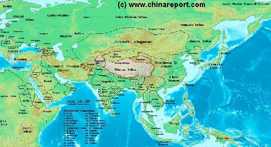
China Report - Map of Ancient Asian Empires and Tribes in Asia 565 AD
An overview Map of Asia Entire clearly demarkating the Territories, Nations and Tribal Area's of the Continent in the year 565 AD. Japan is split between the Yamato Kingdom and Emishi. In Korea three Kingdoms Rule among which the largest Goguryeo. China is split in a Northern Dynasty of the Qi, and a Southern Dynasty of the Chen. While in the Far west the Qi Empire stretches as far West as Dunhuang, the Silk Road is temporarily blocked by the unification of Mongol Tribes in the Gokturk Khanate and the appearance of the smal XiYe City State in the Tarim River Basin.
Asia Report - Map Yuan Dynasty Mongol Empire in Time 1206 AD - 1294 AD
A Schematic Map of the Mongol Empire of Genghis Khan (TeMuJin) and descendants through its several stages of conquest in its short but Impressive Existance in History. Timeline depicts the Mongol Conquest starting in the Year 1206 AD, when Genghis Khan first united the Mongol-Turkic Tribes of Mongolia and Lake BayKal becoming Great Khan. The Timeline continous through the year 1219 AD, the year 1223 AD taking Transoxiania, 1227 AD, 1237 AD when the Northern Jin Dynasty of China was annihilated, 1259 AD conquering ancient China above the Jiangste River and 1279 AD when all of China was taken and the Yuan Dynasty Eastablished under the Kublai Khan. Last is the Year 1294 AD when the Mongol Empire reached its largest geographical size and Zenith, 22% of world land area, but through lack of central leadership and over-expansion fragmented into 4 large parts, then imploded upon itself.
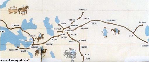
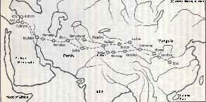
Asia Report - Map Trade Routes in Asia in the 13Th Century
A Schematic Map of the Eurasian Trade Routes existing in the 13Th Century. Clearly marked in Red Accent on the Map are the cities of the network of land-bound trading routes through Central Asia known as the Silk Road (the path of Marco Polo and others). Marked in Blue Accent are the Main Ports and Harbors of the Maritime Trade Routes that operated between the Arabian Peninsula and the Red Sea, the Indian Ocean and Coastal Cities, the Straights of Malacca, the South-China Sea's and beyond. As shown Maritime Trade to China mainly entered through Southern Harbors, then was distributed internally by use of the Grand Canal, the Yangste River and the Yellow River.
Map includes the Route travelled by Marco Polo, William of Rubruck and John of Pian de Carpine, the three famed European Travelers of the Time.
Locations of Main Trading Ports and Cities on Trade Routes of the Time are marked.
Asia Report - Map Yuan Dynasty Mongol Empire in Time 1300 AD - 1405 AD
A Schematic Map of the Mongol Empire of Genghis Khan (TeMuJin) and descendants through its several stages of conquest in its short but Impressive Existance in History. Timeline depicts the Mongol Conquest starting in the Year 1206 AD, when Genghis Khan first united the Mongol-Turkic Tribes of Mongolia and Lake BayKal becoming Great Khan. The Timeline continous through the year 1219 AD, the year 1223 AD taking Transoxiania, 1227 AD, 1237 AD when the Northern Jin Dynasty of China was annihilated, 1259 AD conquering ancient China above the Jiangste River and 1279 AD when all of China was taken and the Yuan Dynasty Eastablished under the Kublai Khan. Last is the Year 1294 AD when the Mongol Empire reached its largest geographical size and Zenith, 22% of world land area, but through lack of central leadership and over-expansion fragmented into 4 large parts, then imploded upon itself.
China Report - Colonialism - Growth of Colonies & Japan after 1801 AD
A Map drawing of the Eurasian continent , parts of North-East Africa and the Middle East in the 19Th Century between 1801 AD and 1900 AD. Focal points are the expansion of western colonial posessions of Portugal, Britain and France, as well as Russia moving from West to East. Labeled seperately is the later Rise of the Empire of Japan in the East.
Included in this Map are the main cities across the continent with their brief histories and events during the 19Th Century. Marked in Colors for clarity are the various colonial and imperialist Nations. As relating to China; special attention is payed to so called Treaty Ports. The First Treaty Ports were forced open by Britain in the year 1841 AD, but counted over 80 in total by the end of the 19Th Century. The most important Treaty Ports in China are marked and described with a short history where the map allows. Follow the links for more information on each location and subject.
China Report - Map of the Ancient Silk Road during the Han Dynasty & Roman Age 2
A Schematic Map depicting the Full Length and main pathways of the Ancient Silk Road during the Han Dynasty Period (206 BC - 221 AD) and Roman Age (30 BC - 630 AD).
In 30 BC the Roman Empire started trading with India, which was already well known from the Conquest of Alexander the Great (+/- 330 BC). In
the following 6 centuries the West would Trade with India and indirectly also with China through the Silk Road. Meanwhile maritime trade developed on the oceans. The Silk Road only lost its Value after the European Age of Discovery and the Establishment of Maritime Trade Routes with India (16Th Century) and later China. The Yellow River is crossed at Lanzhou, after which Dunhuang is the Last Station in China.
China Report - Map of the Ancient Silk Road during the Han Dynasty & Roman Age 1
A Schematic Map depicting other details along the Full Length and main pathways of the Ancient Silk Road during the early Han Dynasty Period (206 BC - 221 AD).
As seen from China the Silk Road extends due Westward from Chang'An (Xian) the Han & Tang Dynasty Capital. The Yellow River is crossed at Lanzhou, after which Dunhuang is the Last Station. This Map depicts the Lost Civilizations of Loulan and Hotan, as well as the
south route and north route of the Silk Road coming together at Dunhuang in current day Gansu Province of China.
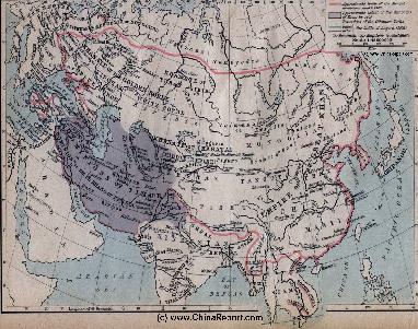
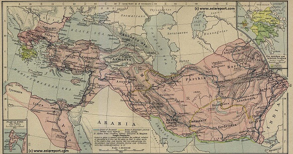
Asia Report - Map of the Macedonian Empire (336 BC - 323 BC)
A Full Map of the extended Empire of Alexander the Great (of Macedon). Starting his conquest in earnest in 336 BC Alexander the Great defeated the Great Persian Empire, conquered Egypt and advanced through Central Asia as fas as the Hindu Kush and the Heavenly Mountains (Tian Shan) forming respectively todays border of India-Pakistan and more to the North, the border of Xinjiang-Uygur Autonomous Region of China. After conquering the
Persian Empire, the Empire of Alexander the Great of Macedon included Afghanistan, Tajikistan, Kyrgyzstan, parts of Uzbekistan , etc. The Arabian Peninsula was never vanquished.
China Report - Historic Map China + British Empire 1860 AD
A Map drawing of the Far East -China, Japan, Korea, Phillippines, Indo-China, Burma, India and Indonesia- in 1860 AD. Depicting the expanding British Empire in Asia and the Far East in 1860 AD, with a Focus on China and Indo-China. British Power has surpassed that of the Dutch (and Portugese) in Asia. British Territory includes India, Burma, Nepal, Bhutan, Sikim and other strong-points scattered around. Hong Kong is now British (1842AD). Tibet and the bulk of China have come under pressure from Britain.
Asia Report - Historic Map Asia + British Empire 1897 AD
A Map overview of the World in 1897 AD depicting the extenses of the British Empire in North America, Africa, the Mediteranean Sea and the Middle East, Asia and the Far East. British Power is at its highpoint. British Territory includes India, Burma, Nepal, Bhutan, Sikim and other strong-points scattered around. British Controls Hong Kong and has large influence in other Chinese Treaty Ports. Tibet and the bulk of China have come under pressure from Britain. In the next few years parts of Tibet will be annexed.
China Report - Colonialism - Growth of Colonies & Japan after 1801 AD
A Map drawing of the Eurasian continent , parts of North-East Africa and the Middle East in the 19Th Century between 1801 AD and 1900 AD. Focal points are the expansion of western colonial posessions of Portugal, Britain and France, as well as Russia moving from West to East. Labeled seperately is the later Rise of the Empire of Japan in the East.
Included in this Map are the main cities across the continent with their brief histories and events during the 19Th Century. Marked in Colors for clarity are the various colonial and imperialist Nations. As relating to China; special attention is payed to so called Treaty Ports. The First Treaty Ports were forced open by Britain in the year 1841 AD, but counted over 80 in total by the end of the 19Th Century. The most important Treaty Ports in China are marked and described with a short history where the map allows. Follow the links for more information on each location and subject.
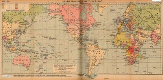
Colonialism - 1912 World Map of Colonial Possessions & Trade Routes
A Map drawing of the World depicting the Colonial Possessions as they were distributed in 1912 AD. Superimposed and marked in colors are subsequent changes in Influences Spheres, colonies and possessions due to World War I ( 1914 AD - 1918 AD).
Included in this Map are the main cities across the continents with their brief histories and events during the late 19Th Century and early 20Th century, where relevant. Marked in Colors for clarity are the various colonial and imperialist Nations. As relating to China; special attention is payed to so called Treaty Ports. The First Treaty
Ports in China were forced open by Britain in the year 1841 AD, but counted over 80 in total by the end of the 19Th Century.