Compare Maps and follow Links to more Information and Photo's !
This Satellite Image Map clearly depicts the Olympic Park of Beijing and the adjoining Ethnic Minorities Cultural Park (or Museum) found on the border between Haidian District and Chaoyang District in Northern Beijing. The original image was taken in July of 2008 by GEOEYE.
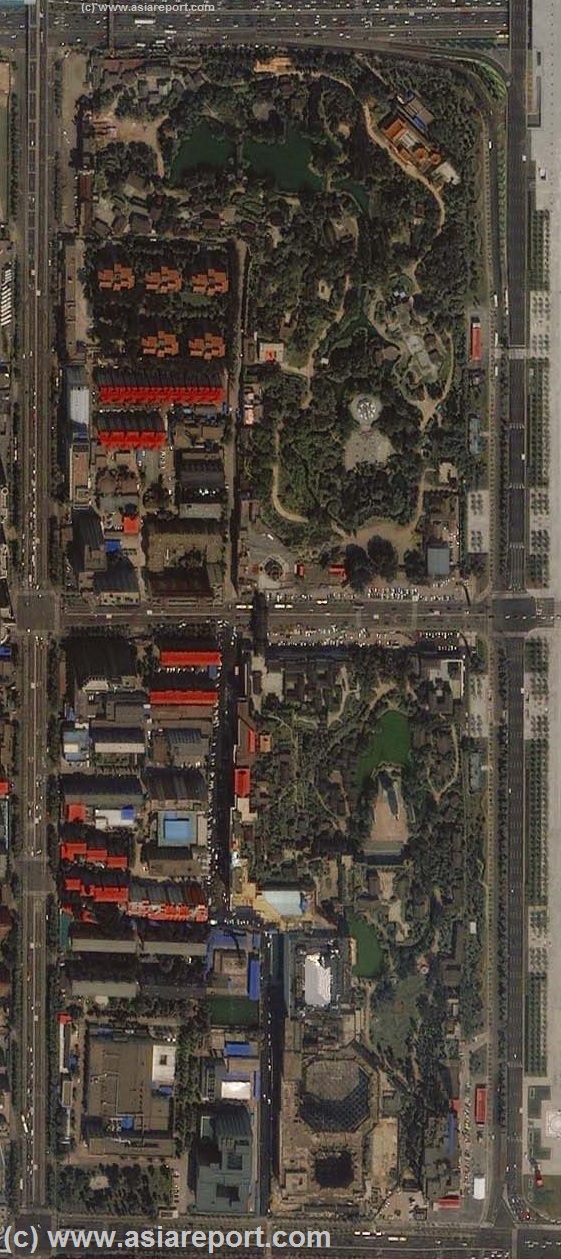
All major boulevards, streets and side-streets are depicted. Major and most notable architectural landmarks, relevant subway stations, Temples, Parks and various other sites of interest within each area are marked on the map with a link to further information.
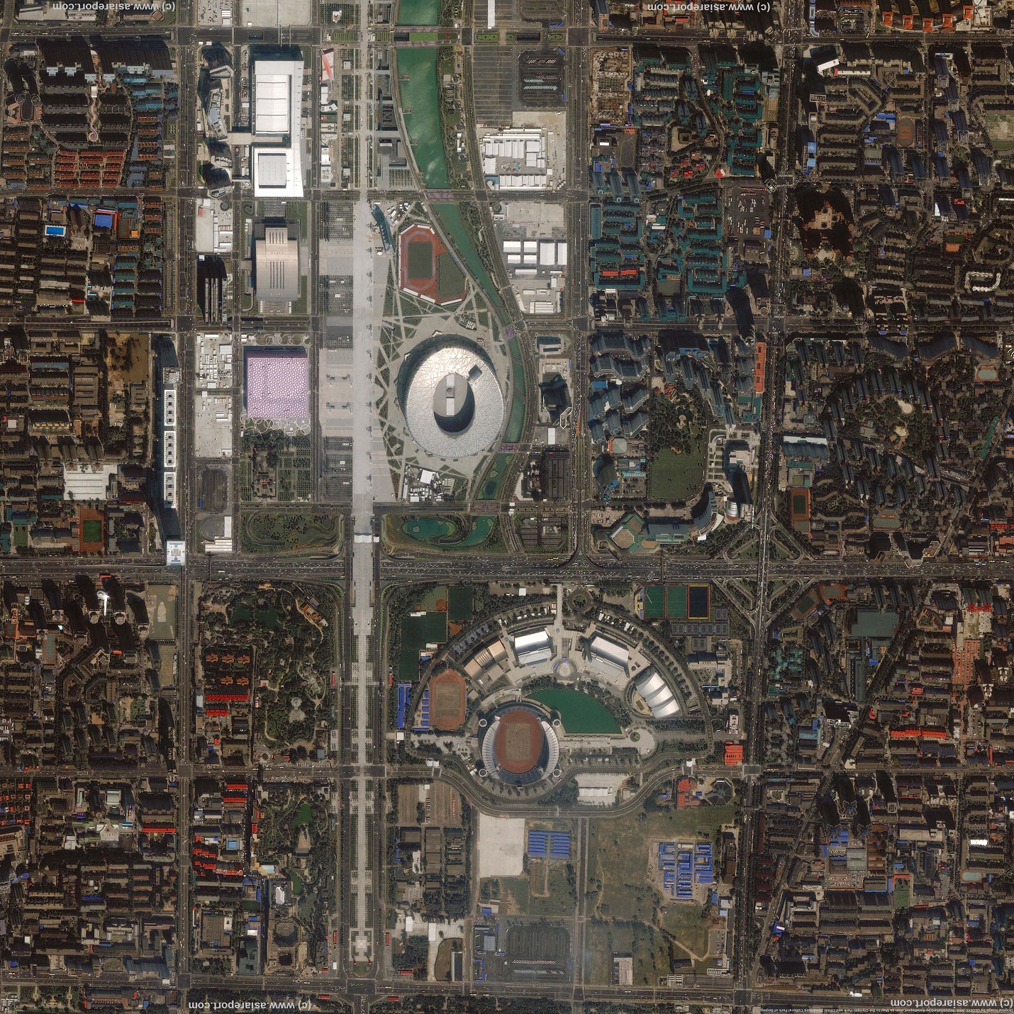
Map roughly covers the area between between Olympic Forest Park in the North, Asian Games Village in the East and Yuan Dynasty City Wall Ruins Park in the south.
Main Landmarks are marked on yellow background (        ), former residence (museums) in cream color (        ), stores of interest in pink (        ) and various other help points and facilities in light green (        ).
Introduction to Sat Map Beijing Olympic Park & Ethnic Minorities Park 01
Click Area Image to go through to Full Version !
Taiwan
Return to: Beijing Maps - All
Go to www.drben.net webring
ChinaReport.com at
To Main Menu of All Websites at DrBen.Net
May 4Th Monument
Grand Hotel Beijing
Archeological Ruins of Former Bridge + Air Raid Shelters
This page was last updated on: June 6, 2017
My Great Web page
All Maps Menu by The Beijing Reporter
A Geographic Overview Map of the Districts of Beijing within the 5th Ring Road
Overview Map of the Central City of Beijing as well as the first ring of Inner Suburbs.
Mouse over Map to discover varrious area's, click and follow the links to additional maps, information and photo's.
For completeness, Link options to two additional overview maps of roughly the same area are provided underneath this map.
Beijing Landmarks
Beijing Introduction
Beijing Online Sources
Beijing
Beijing Home
Beijing Hotels
Beijing Maps - Index
Beijing Public Transport
City Province Transport
Beijing by District(s)
Chongwen
ChaoYang
Dongcheng
Fengtai
Haidian
XiCheng
Xuanwu
6 Outer Suburbs
TiananMen Square
Alphabetical Order
By Function(s)
Forbidden City
Beijing Air Fares
Beijing Car Rental
Beijing Cruises
Hebei Province
Hebei Province Home
China Offline Sources
AsiaReport.com Home
China Report Home
China Online Sources
China Online Store
China Maps
China
China Photo Galleries
China Report Club
4 Rural Districts
Shijingshan
Maps of Chaoyang
Maps of Chongwen
Maps of Dongcheng
Maps of Fengtai
Maps of Xicheng
Maps of Xuanwu
Maps of Haidian
Maps of Shijingshan
Beijing Great Wall Maps
Beijing North China Maps
Historic Maps of Beijing
BJ Public Transport Maps
Da
Huozi
Beidingcun
Mc
Donalds
South
Gate
National Aquatics
Center
Beiding
NiangNiang
Temple
Xidan
Go to Full Map of the Ethnic Minorities Park (also Museum Park).
Get our toolbar!
Fuxing Men
Chadaokou
Check out MEGA - 100% Secure file-sharing by Kim.com !!
Click Map Image to go to Full Version !!
Beitucheng
Beitucheng
Subway
Station
Holiday
Inn
Express X
Yuan Dynasty City of Dadu City Walls Park
AnzhenMen
Subway
Station
Caobalicun
Aoti Middle Road
Minorities Park (Minzhu Yuan) Road
Minorities
Park
South
Minorities
Park
North
Olympic Sports
Center
Subway
Station
Olympic Sports
Center
Stadium
Olympic Sports Center
Training Stadium
Aoti Apts.
Yingdong
Natatorium
Beijing
Aoke
Golf
Club
Olympic
Golf
Driving Range
Hospital
Football
Training
Ground
National Indoor
Stadium
Olympic Green
Subway
Station
Olympic Forest Park
Entrance
Birds Nest
Stadium
Grand
Catic
Skylight
Hotel X
Central Area
East Gate
Central Area
North Gate
Intl. Jade
Hotel X
---->
Linglong
Pagoda
Performance
& Art
Center
China
National Convention
Center
China
National Convention
Center
Asian Games
Village
Trampoline
Club X
Billiards
Club X
Bank of
China
Chinese Academy
of Sciences Blds.
Chinese Academy
of Sciences Blds.
Chinese Academy
of Sciences Geology, Geophysics
Chinatown
Commercial
Plaza
Korean
Hezhen
Hot
Pot
Continental Grand
Hotel X
Datun Culture Square & Garden
Jinquan Homeland
Residential Towers
Woolong
Garden
Villa
Beijing
Aobosen
Hotel X
Currently
a Construction
Site
Currently a Park Area
with Trees
and Grass
(unpaved)
Currently a Park Area
Xin'Ao
Shopping
Center
CNCC
Grand
Hotel X
Intercontinental
Hotel X
Beijing
Beichen
A Geographic Map of North ChaoYang District (2010) - Olympic Green & Olympic Park.
Click Map to go to Full Version !!
Map of North ChaoYang District focusing on the 2008 Olympic Green (or Olympic Park) in the recently transformed North section of ChaoYang District. Included in the map are large parts of adjacent Districts of Haidian, Changping, Dongcheng- and Xicheng.