This Map provides a clear overview of most structures, palaces, towers and pavilions within the Beijing Summer Palace Park (YiHeYuan; Literally "Gardens of Nurtured Harmony"), located in the North-Eastern section of the Haidian District. The Map is however NOT complete and omits several sections of the extensive Palace Gardens on the South- and West sides of Kunming Lake. Miniature impressions of these parts are included in the set-in box.

The first structures within the Park date from the year 1750 AD during the Qianlong Reign of the Qing Dynasty (1644 AD - 1911 AD) when the Palace was started as the "Garden of Clear Ripples". It grew into the main Imperial Summer Retreat after the burning of the Yuanmingyuan Summer Palace in 1860 AD. The Beijing Summer Palace Park was declared a (UNESCO) World Cultural Heritage Site in 1998, and remains the single most splendid example of preserved Chinese Imperial Palace Garden Architecture in the world today. (The other examples are Beihai Park (Beihai Gongyuan) in Beijing and "Fleeing the Heat Mountain Villa" (Bishu Shanzhuang) in Chengde (Jehol), Hebei Province). The extensive Palace Garden Park covers an a total area of 2.9 square kilometers and includes the largest hand-dug lake in the world, Kunming Lake.

Browse the Map to find the names and location of each Palace, Pavilion or Monument within the Palace Park or refer to Yiheyuan - Summer Palace Map 2 for an alternative. Follow the links where available to more information and photos on each subject of interest.
Introduction to the Summer Palace Park Museum Map
To Summer Palace Introduction
Marble Boat Information
East Palace Gate )Donggong Men) - Start of Tour
WenChang Imperial Art Exhibition
WanSheng Tower
Chang Lang - Long Corridor
Go to www.drben.net webring
To Main Menu of All Websites at DrBen.Net
ChinaReport.com at
Bronze Bull
Dragon King Temple
To Summer Palace Introduction
North Palace Gate (Bei Men)
Suzhou Street & Long Brdige
Temple of Buddhist Virtue (Fo Xiangge)
Gate Tower o/t Dawn of Light (Yinhui Chengguan or Yinhui men)
Glazed Ware Dagoba (Duoba Ta)
Kunming Lake South-East Shore
Happiness & Longevity Hall
17 Arch Bridge
Black Dragon Hall & Dragon King Temple
Hall of Embracing the Universe
All Maps Menu by The Beijing Reporter
Temple of Scattering Clouds (Paiyun Dian)
Temple of Virtuous Light (Sea of Wisdom) (Dehui Dian)
This page was last updated on: June 6, 2017
My Great Web page
Yiheyuan - (new) Summer Palace Park - Site Map 02, includes most Pavilions and Sites inside the Palace proper but omits large sections of Kunming Lake including the Black Dragon Temple.
Overview the Entire Summer Palace - YiheYuan grounds and Link through to Photos and Backgrounds on Structures and Sites of your Interests.
Click Map Image to go to Full Version !

View AsiaReport.com - Mastermap of Asia (entire). in a larger map
Beijing Landmarks
Beijing Introduction
Beijing Online Sources
Beijing
Beijing Home
Beijing Hotels
Beijing Maps - Index
Beijing Public Transport
City Province Transport
Beijing by District(s)
Chongwen
ChaoYang
Dongcheng
Fengtai
Haidian
XiCheng
Xuanwu
6 Outer Suburbs
TiananMen Square
Alphabetical Order
By Function(s)
Forbidden City
Beijing Air Fares
Beijing Car Rental
Beijing Cruises
Hebei Province
Hebei Province Home
China Offline Sources
AsiaReport.com Home
China Report Home
China Online Sources
China Online Store
China Maps
China
China Photo Galleries
China Report Club
4 Rural Districts
Shijingshan
Maps of Chaoyang
Maps of Chongwen
Maps of Dongcheng
Maps of Fengtai
Maps of Xicheng
Maps of Xuanwu
Maps of Haidian
Maps of Shijingshan
Beijing Great Wall Maps
Beijing North China Maps
Historic Maps of Beijing
BJ Public Transport Maps
Click Map to go to Full Version !
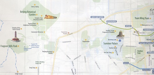
Overview Map of the Yiheyuan Summer Palace Park, Old Summer Palace ruins (Yuanmingyuan), Jade Spring Hill (Yuquanshan), Fragrant Hills Park and Beijing Botanical Gardens in North-West Haidian District.
Overview Map Haidian - Yiheyuan Summer Palace, Fragrant Hills, Botanical Garden
A Geographic Map of North Haidian & North ChaoYang District (2010).
Click Map to go to Full Version !!
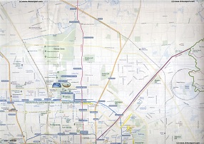
This Map depicts North ChaoYang District focusing on the 2008 Olympic Green (or Olympic Park) in the recently transformed North section of ChaoYang District. Included in the map are large parts of Haidian District in the West (Left), a small part of Changping District in the North, and minor parts of Dongcheng District and Xicheng District in the South. Browse the Map and follow the Links to more information and Photos!