Great Wall of the Northern Qi Dynasty & Yellow Cliff :
Luowenyu Great Wall of today :
- Tangshan, Zhunhua County, Luowenyu Pass - Introduction -
This page was last updated: May 19, 2017
Great Wall of China in Hebei Province
Luowenyu Great Wall Location - Coordinates: 40°16' 53.62" North 117 56' 53.34" East.
The Luowenyu Pass of The Great Wall of China is located at Luowenyu village, a remote part of Houjiazhai Town in north Zunhua County-Level City in Tangshan Prefecture of Hebei Province. Although known as one of the oldest sections with origins dating to over 2000 years ago, it is a short but reasonably preserved length of Great Wall just outside of town located above with Zunxing road.
In history the Luowenyu Pass was key pass of what was known as the "Ji Town Great Wall". According to the historic source known as "The Chronicles of the Four Towns and Three Passes, " Luowenyu Pass was built during the Hongwu Reign ( 1368 AD - 1398 AD) (of the Ming Dynasty).
Luowenyu Pass has a narrow gate way with only four meters in width, so it was easy to hold but difficult to attack. The pass town was built closely against the Great Wall. An inner town was formed near the pass against the trunk and branch of the Great Wall.
This section of the Great Wall was built of stones except for the 322 meter-long middle section which was built of bricks. Arrow openings and loopholes were built on the surface of some walls.
West of the pass lies a well-preserved, stone-built defending slope which is the branch of the Great Wall. It is 1.4 meters wide, 4.4 meters high, about 30 meters long and only 30 meters away from the town of Luowenyu.
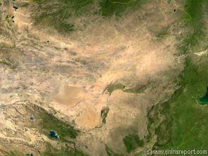
China Report - Map of the Gobi Desert & Yellow River Flow
A Satellite Image Map of the Entire Gobi Desert Region. Map overviews North-West Xinjiang Autonomous Region, Mongolia, Inner Mongolia and North and North-Eastern China giving a Full Overview of the Gobi Deserts. Clearly visible details of geographical features such as mountain ranges, rivers, valleys and lakes.
Map includes country borders, name and location details of Cities and Villages (clearly visible).
Mouse over Image to Reveal more information and follow the flow and path of the yellow river from Xining in Qinghai Province to the Bohai Sea. Details of old / former Yellow River flow (south of new) and new trajectory to the Bohai Sea.
repairs have been made to prevent further damage to the site by means of the climbing of visiting tourists. Although to reach the unrestored Luowenyu Great Wall sections hikers must truly go off the beaten path, fording a shallow stream and climbing for an
hour through terraced orchards before scrambling onto the wall itself, the site is on the itenerary of several guided hiking tour companies specialized in Great Wall hiking tours.
Nearby Luowenyu Great Wall is the Eastern Ching Dynasty Tombs or Qingdongling Site. Qingdongling
is a large group of Burial Tombs which hold the remains of 5 emperors, 14 empresses and 136 imperial concubines and princesses of the Qing Dynasty.
Among these is Ding Dong Ling, the Tomb of the renowned and notorious Empress-Dowager Hsu-Tzi, or Cixi the Dragon Lady. For the occassion of the Burial of the Empress Dowager in 1908 AD, a 125 kilometer long road was constructed to reach between Beijing and Ching Dong Ling. The Tomb of the "Venerable Old Buddha" as the old Lady was known to her courtiers was robbed and pillaged in 1925 AD, when an unpayed warlord army descended on the Site. Searching revenge for old sufferings, as well as riches for the future, a giant black pearl lodged in the mouth of the dead corps was wedged out and taken, never to be seen again. Many other priceless relics disappeared from this richest of all Ching Dynasty Tombs (or so it was said)).
The Eastern Qing Tombs, which is among the finest, best-preserved and largest of the extant tomb complexes in China, is located along Changrui Mountain in the west of Malanyu Town, in Zunhua County. Among the Tombs set along the south side of Changrui Mountain the largest and most popular Tombs is that of Emperor Shunzhi (Reign 1638 AD - 1661 AD the first Qing emperor to rule the territory of what roughly today is The Peoples Republic of China). The second Tomb of the extensive site is the broken and repaired Tomb of Empress-Dowager Hsu-Tzi (Cixi).
The Graves sites are arrayed based on the traditional concept of placing the most senior and most distinguished in the center.
The beauty of the landscape is enhanced by yellow-glazed tiles of the Mausolea dotted among green pines and cypresses.
A Full Google Earth Supported Map of Luowenyu Great Wall by Google.com.
The China Report introduced on Levels of its Online Publishing's in April of 2009, including The Great Wall of China.
Adjacent Map gives direct access to Luowenyu Site Map by Google Earth.
Today the two highest watchtowers have fallen as well, leaving but one to admire. Among the mainly ruins of the Wall at Luowenyu are 1 meter high great wall remnants and various watch towers cutting along the hillside above the town.
At Luowenyu the Great Wall of China used completely unrestored, however in recent years
The Great Wall of China at Luowenyu is one of the sections famously recorded and photographed by William Geil, who was the first foreigner to travel the length of the Great Wall and Photograph it, in 1908 AD.
At the Time the Luowenyu Pass site was already in dilapidated state. Only a small stretch of the west wall as well as 3 watchtowers, perched on a hillside above the town remained.
The Last Battle at Luowenyu Great Wall was fought in the 1930's, when Japanese Forces in Manchuria began trickling down into the North-Chinese Province of Hebei (Hopei at the Time). In spring of 1933 AD it came to a battle with the Japanese invaders at the Great Wall area on the Liaoning Province Border. In a first incident, the Japanese invaders were resisted and defeated at Xifengkou by Kuomintang troops. After changing their strategy, the Japanese invaders began to attack Luowenyu and Longjing passes in North-East Hebei Province. Later in 1933 AD the 29th Army was in Battle with the Japanese invaders at Luowenyu Great Wall for three days after which the Japanese had been repelled.
Eventually the Batlle was to no avail, as the Japanese pressed on. Feeling little resistance from the Kuomintang Central Government in Nanjing, the Japanese, using the already captured Manchurian Provinces as a base, went on the gain strength and move into North-Eastern Hebei. By 1937 AD, the Lugou Qiao or Marco Polo Bridge Incident outside of Beijing finally forced what had long been an inevitable war with the Japanese.
A Full Google Earth Supported Map Overview of All Structures of the Great Wall of China from East to West, by DrBen.Net (c) ChinaReport.com and Google.com.