The Zhangjiakou Report is part of the overall website www.ChinaReport.com & www.drben.net
Learn about what is new on this Site from below window.
ChinaReport.comat
Dynasty court hoped to reach Chengde (Jehol) the location of the Manchu Fleeing the Heat Mountain Villa (Bishu Shanzhuang) which usually served as a sort of secondary Capital. However, hearing rumors of alien troops traveling on interception course to cut off the flight path, the party made a turn around at Zhangjiakou, subsequently heading to Xi'An, the ancient Capital of China along the Wei River in Shaanxi Province. Eventually the Empress-Dowager would spend a year at the Huaqing Palace at Lintung near Xi'An, after which she would make a triumphant return to her ancient Capital. All the time the Guangxu Emperor was towed along.
After the dismal defeat the Boxer Rebellion, the burning of the Yuanming Yuan Palace (Garden of Perfect Brightness), the plunder of the city of Beijing and its Forbidden City and further humiliations of the Chinese in the Boxer War (1900 AD - 1901 AD) Foreign dominance of China was nearly complete. In all but name China had become of shared Colony of the Foreigners.
With the Empress-Dowager returned to the Capital and forced to communicate with the various overseas parties interested in dividing up China and distributing its resources across the world, the way was finally made for reforms that had been blocked by the Chinese Court (the Empress-Dowager) from the get-go.
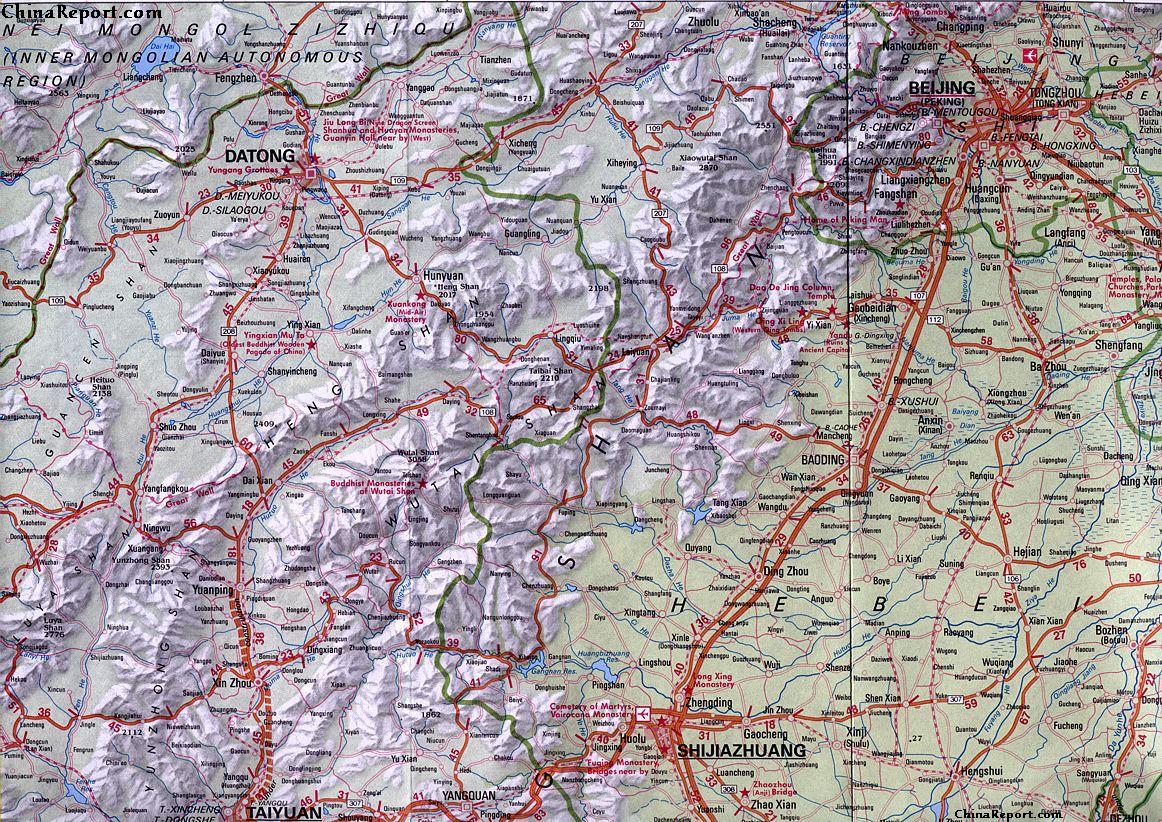
Beijing Regional Map : Datong-Beijing-ShiJiaZhuang-TaiYuan quadrangle, an overview of Beijing Municipality (in Hebei Province) and the Area to the West and South-West of Beijing. Includes Datong, Shanxi Province and nearby Pass to Inner Mongolia (Great Wall of China), BaoDing ShiJiaZhuang and TaiYuan Crossroads-cities. Wutai-Shan and Yuntong-Shan Mountain Ranges.
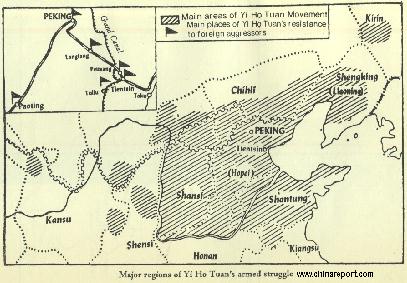
Schematic overview Map of the Area's of North-East China overtaken by the Yi Ho Tuan Movement (The "Boxers").
EARLIEST HISTORY OF ZHANGJIAKOU:
The earliest historical mentions of place now known as Zhangjiakou dates back well over two millenia. As recorded and preserved in Chinese Tombs, maps and writings, in the so-called Spring and Autumn Period (770 BC - 476 BC) which led to the final demise of the Zhou Dynasty (1121 BC - 255 BC), the northern parts of the current day Prefecture of Zhangjiakou were grasslands claimed by the mighty and notorious Huns, a pre-Mongolian nomadic tribe of now legendary military prowess. At the same, the Southern parts of today's Zhangjiakou Prefecture was a territory claimed by the early Chinese Yan Kingdom. At the very end of this "Warring States Period" all seperate Kingdoms and States had been conquered by the militarily strong state of Qin uniting them into what is held to be the first ever united Chinese State with a centrally administered system. In the process, where today's Zhangjiakou was previously part of Yan, where it was a border town, it was now part of the Chinese Qin Empire. The Qin Era, although very brief left a lasting imprint on Zhangjiakou and its prefecture.
In the aftermath of the Boxer War, the foreigners, operating from within the safety of their extra-territorial zones within the Beijing Legations - an exclusive diplomatic zone within the City Walls of the Capital - and the nearby Port and Banking Center of Tianjin, gained unprecedented access to and influence within Chinese Territories.
While the Beijing Legations thrived as never before in complete denial of the latest Chinese attempt to expell the Foreigners, now throughly hated, many of those seeking fortune built upon the new influx of foreign investment money and the opportunities provided by the failing of power of the Dynasty.
Although counted as yet another much lamented episode of modern Chinese History, the final eroding of Central Powers (as provided by the Qing Dynasty) did also provide the first opportunity for the Chinese Nation to modernize. The shackles applied by the now seemingly irrational conservatism of the Qing Court had been broken, giving way to opportunity for the many reform minded within the Nation. The newly arisen situation immediatly lead an enormous economic boom.
The first aspects of the modernizations were the appearance of western technologies, including the highly visible railroads. With the Capital of Beijing and the port city of Tianjin - the new Banking Capital of the north-east - already connected before the Boxer Rebellion inflamed the nation, afterwards the next step in the economic development and the opening up of the heartlands was the extension of railroads beyond the Capital. These railroads mainly served for the transport of heavy goods and also for military purposes, and so almost naturally among the first new railway lines to be built was a line leading from Beijing to the mineral rich border town and military garrison of Zhangjiakou (Kalgan), the Pass City of the Great Wall of China.
The Imperial Peking–Kalgan Railway (now the "Jingzhang" Railway) was constructed between 1905 AD and 1909 AD. The line became available in October of 1909.
All previous lines, including the line(s) to Beijing were in effect owned and operated by Foreign conglomerates from various Nationalities such as Japanese, Russian, British. American, French, German and others, and had been built to support the Foreigners in their military advances and inititial economic exploitations of the Chinese Nation. As a result, the Foreign owned lines mainly connected between the main population and economic centers along the coastline and Chinese involvement or control was none existent.
The Zhangjiakou-Beijing line however was an entirely new kind of line as the Beijing-Zhangjiakou railway line was the first ever all Chinese designed and constructed railway in China. Based purely upon Chinese National interests it was built order to gain access to the coal deposits found around Kalgan and enhance communications with what was still the de facto Chinese border station on the Mongolian Border.
In its time to conquer the mountainous ring north of the Capital with a railroad was a formidable achievement, in hindsight revealing a first glimpse of the Chinese nation eager and able to advance on their own terms.
As a result of its history, today, although having become part of the much longer Jinzang Railway and extended to Baotou in Inner-Mongolia (Autonomous Region), the spectacular route of the Beijing to Zhangjiakou is still hailed as the "Father of all Railway Lines" in China and offers one of the most interesting train rides available in all of North China.
The 1911 Encyclopedia Britannica noted that, in Kalgan, "the ordinary houses have an unusual appearance, from the fact that they are mostly roofed with earth and become covered with green-sward" and that "on the way to Peking the road passes over a beautiful bridge of seven arches, ornamented with marble figures of animals".
In 1927, the text that currently decorates the lintel of the Gate to the Great Territory (Dajing Men) was written by the local warlord and last "President" of the Hopei-Chahar region.
Mongolia into the Russian sphere of influence, at the same time bringing the Sino-Russian border within 200 kilometers from the Chinese National Capital. Apart from parachute droppings in and around the city of Baotou along the Yellow River (Huang He) in Inner Mongolia, the invasion involved the taking of the cities of Zhangjiakou and Jehol (Today: Chengde) both situated on vital access roads to the "Northern Capital" Beijing. If the Russians would have wanted it at the time, the could have taken Beijing itself and subsequently establish a puppet Government with claim to all of China. However, for various political reasons, in the end a decision was made against any such action.
threatening and impressive enough for Mao Zedong to start making plans for moving the Communist Capital from Yen'An in Shaanxi Province to Zhangjiakou, so that if and when the northern Capital would fall (presumably to a Communist Russian advance as the Chinese Communists were in no position to do so), Mao could easily be installed as the new Leader of a Marxist China supported fully by the Soviet Union (C.C.C.P. / U.S.S.R.). As the book claims, camel caravans laden with Government Documents and equipment had already been sent from Yan'An.
However, although this is roughly what happened in neighboring Korea this was a scenario that would never develop in China and the Civil War in China eventually lasted until the 1st months of 1950 AD, only briefly before war broke out between North and South Korea. All of this was no coincidence.
Although the Russians would eventually withdraw, the powerplay of the Russian side would not unnoticed by the Chinese Communist Party and the threat from Russia became a long-term concern of China and its Leadership.
After the brief cease-fire in the (2nd) Chinese Civil War between the Communists and Chiang Kai-Chek's (Jiang Yishi) Nationalist armies in June of 1946 AD Zhangjiakou was the only important city in the region in the hands of the Communist side. In June the city was attacked by Nationalist troops, who at that time were still far superior to the Communists in both weaponry and numbers and the city fell in October. After this battle the city fell back in the hands of the Kuomintang National Government while the communist forces faded into the surrounding country-side and the rough loess hills of adjacent northern Shanxi Province, territories which they had held for years already. That winter was the coldest winter in many years and the communist forces made use of the extremely low temperatures make small guerilla attacks and ambushes. Although the strategy was successful in undermining the military position of the Nationalist Armies in Zhangjiakou, the majority of casualties fell on the Communist side as their armies were inadequately supplied and dressed. According to interviews with long since retired veterans of the P.L.A. the winter of 1946 caused over 100 thousand casualties from freezing alone among the assembled Communist soldiers. Their commanding officer, was hailed by Mao Zedong for his "ruthless efficiency" and later even made it to the rank of 2nd in Command under his ultimate leadership. This officer, General Lin Biao, is well remembered as the main person in charge of the Chinese Military during the turmoil, crackdowns and political suppression during the 1960's and the "Cultural Revolution Era" at the end of which the Chinese Army was the most important power in the Nation. Although Lin Biao was a succesful General know for various historic raids and battle victories, the morality of his style of Leadership was questionable at best and over time had huge repercussions for his subordinates.
In the early 1960's at the height of Sino-Soviet tensions caused by the De-Stalinization process in the Soviet Union and Mao Zedong's denunciations and hatred for it that Zhangjiakou briefly became the vital strategic border point between two rivalling Nations. At least, in propaganda skeems which perhaps tried to revive some of China's rich history for the sake of mobilizing the nation, it was considered one of the most important cities in China (P.R.C.) from a military strategic viewpoint. At this time, when Russian tank armies stood battle ready along the border in the south of the Republic of Mongolia, Zhangjiakou was commonly nicknamed, "Beijing's Northern Door", because whoever controlled Zhangjiakou would be able to hold or take the National Capital of Beijing. While tensions lingered well into the notorious Cultural Revolution period ( 1966 - 1976), the citizens of nearby Beijing dug a network of tunnels in the hope of surviving the expected nuclear war (See: Beijing Underground City Air Raid shelters). Luckily, regardless of all the fear and paranoia, in the end the Leaderships of both nations were sufficiently sane not to attempt any such thing. However, smaller scale skirmishes and offensives did occur along the Mongolian border and more specificially up in the north along the Amur Border river. In the end, no war came to Zhangjiakou at all.
In 1995, after heavy rainfall, a section of the Great Wall of hina immediatly west of Da Jing gate, collapsed. According to an article named "Trading Places" (see offline sources) in China aily newspaper, the wall section was rebuilt a year after but remained closed to the public.
Jin'An
Tianjin
Beijing
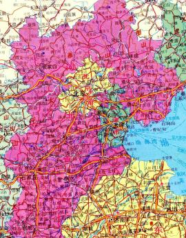
Hebei Province Map 2 - Schematic Map - Large
A schematic overview of North-East China's Hebei Province entire, delineating Provincial Borders and parts of neighboring Shanxi-, LiaoNing- and Shandong Provinces and Inner Mongolia Autonomous Region. The Map clearly marks the location of Qinhuangdao and gives an overview of the remaining Great Wall sections in the surrounding regions.
China Report - Map of the Great Wall during the Ming Dynasty
Satellite image of China and North-East Asia, with a super-imposed schematic Map of the location and Path of the Great Wall as constructed during the Reign of the Ming Dynasty. Included for reference are City names, geographical features of landscape, Names and locations of Passes on the Great Wall of China.
ZHANGJIAKOU DURING THE QING DYNASTY (1644 AD - 1911 AD):
In the year 1697 AD, Emperor Kangxi of the Qing Dynasty (Reign 1661 AD - 1722 AD) personally led an army nothward from his Capital in order to subdue an invasion by a rebellious Mongolian Tribe. In the aftermath of the battles which ended in a victory for Kangxi and his armies, the army passed back through the Da Jing Gate of Great Wall of Zhangjiakou. As a celebration and in order to instill the defeat into the public memory a local scribe, one Zhang Zizhong, was asked to write a commemorative text meaning "Both Sides of the Great Wall Have Been United". This text was then hewn into a prominent cliff along the road to the Da Jing Gate large enough for everyone to see.
In 1709 AD the Kangxi Emperor of the Qing Dynasty (Reign 1661 AD - 1722 AD) keeping an eye on territorial incursions by Russians arriving from the North, led an expedition through the area and camped his army at Kalgan (Kyoto in Manchu terms). However, as the legend goes the Dajing Gate of the city was closed and no one would open. Later, the subsequent forced camp out was commemorated with the construction of the Reclining Dragon Pavilion( the Dragon symbolic for the Emperor) in the area outside the gate.
Early in the 19th century, the town of Zhangjiakou was the seat of a very extensive transit trade between Mongolia and Russia on the one side and Beijing in China on the other. Suddenly, Zhangjiakou was a boom town and as the saying went at the time among Russian traders: a man who had made it to Zhangjiakou (Known by the Russians as Kalgan) had arrived in China.
It was the highpoint of caravan trade on the "Tea Road" although by that time many other items and products were traded as well. After the summer heat had dissipated and the rainy season had passed, in early autumn the Camel caravans would start their seasonal journey into Central Asia. At this time of the year, long lines of camels would come in from all surrounding territories at Zhangjiakou, where they were then gathered into huge groups which traveled in steps on to Kyakhta. From Kyaktha, the camels would return with Russian and other goods destined for China. Altogether, during the fall and winter each caravan made an average of three journeys.
As a result of its importance, there were even some Russian migrants, who as is reported had taken up permanent residences and warehouses just outside the gate and city walls.
Zhangjiakou
ZHANGJIAKOU IN THE REPUBLICAN ERA:
In the year 1928, long after the Fall of the Qing Dynasty (1368 AD - 1911), in the year of the establishment of a Kuomintang National Government in Nanjing, Kalgan remained as one of the main trading posts along one of the few traditional roads from the Capital Beijing to the Mongolian Territories and Central Asia beyond. Camel Caravans still trotted along as before however, as a result of the introduction of the railroads Kalgan now also lay within reach of Foreign Treasure seekers and explorers of all kinds.
As a result of the 4th Roy Chapman Andrews expedition (National Geographic) of 1928 AD some knowledge and even images of the Town of Zhangjiakou have been preserved from that year. As the adjacent film-reel shows at the time, it was still a dusty and rather primitive place and much of the Great Wall of China in the area was still relatively well preserved. As for the wider regions, one of Chapman Andrews' Books leaves us a description of the situation at the time; "In the winter, when the dried vegetation exposes the surface soil, the whole aspect of the country is changed and then it does resemble the popular conception of a
desert. But what could be more desertlike than our north China landscape when frost has stripped away the green clothing of its hills and fields?". "The Chinese have already demonstrated the agricultural possibilities in the south and every year they reap a splendid harvest of oats, wheat, millet, buckwheat and potatoes. On the grass-covered meadowlands, both north and south of the Gobi, there are vast herds of sheep, goats, cattle and horses, but they are only a fraction of the numbers which the pasturage could support. The cattle and sheep which are exported through China can be sent to Kalgan "on the hoof," for since grass is plentiful, the animals can graze at night and travel during the day. This very materially reduces the cost of transportation".
Regardless of its natural and scenic beauties however, Kalgan was hardly a paradise to live in. During the previous years of the Chinese Civil War the border area's to which Kalgan still belonged had yet again fallen into disarray in the absence of normal central authority. In the north White Russians and Cossacks ran wild in the Mongolian territories. Although a "Central Government" was being proclaimed in Nanjing, most of the Chinese Provinces were still under the control of regional warlords and in the case of Kalgan, banditry was rampant along the routes leading to the west and to Central Asia. Basically, with the city serving as an important Garrison town, Kalgan was the last refuge of civilization before entering the "wild west" like regions beyond.
The First Roy Andrews Expedition into Inner Mongolia was not undertaken in 1928, but occurred several years earlier, in the spring of 1922 AD. In that year, after living in the Beijing Legations Quarter for some time already, Chapman, after endless negotiating with Chinese Authorities having finally been granted permission to travel to Zhangjiakou and undertake an expedition across the border into MongolianTerritories could finally take off in search of the scientific "Holy Grail" of the time, the fossil that would provide the so-called "Missing Link (of Human Evolution)". Although at the time a few foreigners, mainly missionaries, had already traversed the regions, not much was known about the Inner Mongolian Territories, except that out there in the huge expanses of the Gobi Desert some magnificent fossils had been found.
Thus, the race to be the first to arrive in the regions had been on and in April 1922 they passed through the Da Jing Gate of the Great Wall of China, the northernmost gate of the defenses around Zhangjiakou. Andrews Chapman, the flamboyant American had just become the first foreigner to launch a scientific expedition from China into the Gobi Desert in an attempt to find new and alien fossils, and if at all possible, the precious "Missing Link".
Not only was the 1922 Chapman expedition well set up, he was also the first ever Foreigner to traverse the sparse roads in the regions making his way by motor-car. Thus, roaring along in a metal machine and on top of that very well armed Chapman and his expedition presented a never before seen sight to inhabitants of the villages and places in its path. It was truly unprecedented, and through a deal with the American Asiatic Association, which had paid him $30,000 for exclusive rights to publish his stories about the expeditions in the magazine Asia, the whole affair was also transmitted and presented to an audience in China and far beyond. Quite possibly, it was the first time that the names Kalgan and Zhangjiakou were made known to the outside world, certainly beyond Asia.
After the thrilling adventure of the initial Chapman Andrews expedition in 1922, several more followed in the years 1923, 1925, 1928 and 1930 AD, with at the beginning of each, the city of Zhangjiakou as the final
The Empire of Japan capitulated on August 15 of 1945 AD, officially bringing an end to World War 2 in Asia and the Pacific. However, although the Japanese Forces had been defeated, a civil war immediately re-ingnited within Chinese Territories. At this important moment in the history of the Regions, the Russian Armies did not stop their Mongolian and Manchurian war offensives but instead continued their war all by themselves driving deep into northern Chinese territories. Ostensibly in support of the Communist Armies of Mao Zedong and the Chinese Communist Party of China the Russians made a rather cynical use of the suddenly appearing power vacuum in order to fulfill a longstanding Colonial Dream, the inclusion of all of (Inner- and Outer)
station before the Journey into what largely amounted to a big unknown.
The 5 expeditions undertaken were made at a whapping expense. Funded not by Museums but mainly by wealthy American backers, the American Asiatic Society as well as the National Geographic Society of America and later even by the auction of fossilized Dinosaur Eggs found in Inner Mongolia, the price tag of all Chapman expeditions in China has been estimated at around 700.000 US Dollars, which at the time amounted a mind-blowing sum. Thus financed, the Roy Chapman Andrews Expedition became the best organized and best equipped roadshow in North China, leading Chapman - through his own best efforts - to a fame for daring explorations as well as a solid scientific reputation. Altogether, the Chapman Andrews expeditions yielded many museum pieces, countless fossils - among which the first ever fossilized dinosaur egg found (by western scientists) by Georg Olsen at Shabarakh Usu on July 13 of 1923 - and many volumes
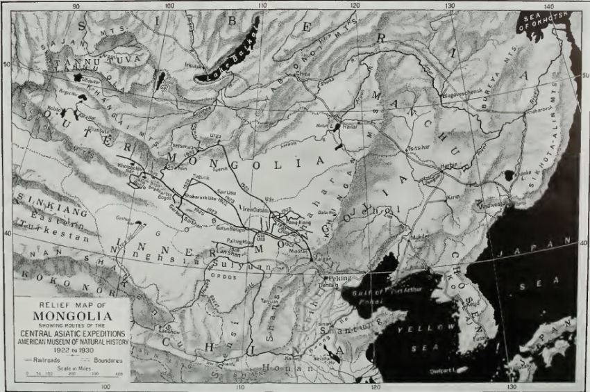
A Map of East Asia by Roy Chapman Andrews depicting the routes of his five expeditions into the Gobi Desert, clearly marking Kalgan as the ultimate last station of Civilization. Taken from the Roy Chapman Andrews Book: "The New Conquest of Asia".
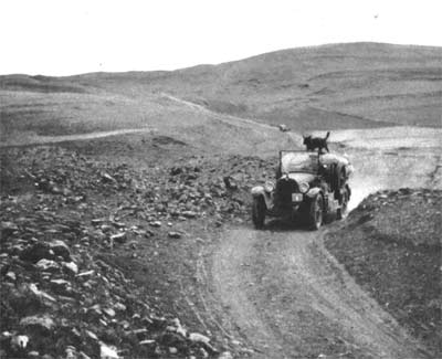
Roy Chapman Andrews blazing the trail into Central Asia in his Dodge motor-car. Photo taken near Kalgan (Zhangjiakou) in current day Hebei Province.
of irreplaceable scientific knowledge on area's hitherto virtually unreported on and certainly not scientifically explored by others than
the Chinese and perhaps the locals themselves.
For a number of reasons, among which the Economic Depression, the Russians accusing him and his team of spying and the Chinese accusations of theft of priceless cultural relics, Andrews and the American Museum of Natural History halted their expeditions into Mongolia in the early 1930's after being forced to cancel the 1926, 1927, 1928 and 1929 expeditions. The 1930 Chapman Andrews expedition was the last one of its kind. Although the find of a graveyard of rare shovel-tusked mastodons, along with other outstanding fossils made this last mission yet another success even Chapman Andrews himself found that conditions in the lawless regions were becoming to dangerous for any foreigner. Because of the dangers, the 1930
expedition had but a brief one, the whole Expedition returned only a month after it had left. Ad Chapman Andrews later wrote about it: "Two days after (our party) had reached Kalgan the entire region was taken over by bandits and all traffic on the plateau ceased. Had our people been delayed, the consequences would have been serious". It was yet another example of the good luck which has been a constant factor in the success of the Chapman Andrews Expeditions. A further line in that book notes "The camels carrying our collections (of fossils) were met at a village thirty-four miles from Kalgan by Young and Liu and the fossils brought safely to Peking".Thus ended the last adventure in the Gobi Desert.Thereafter Roy Chapman Andrews never returned to Zhangjiakou.
Not planned and not also expected at the time, it would be only after 60 years, in 1990, that the American Museum of Natural History was invited to return to China and Mongolia for another scientific expedition and further explorations of the Gobi Desert. In that same year a new team was sent.
READ MORE IN: "Famous Foreigners in Chinese History - Roy Chapman Andrews".
In 1937, after the so-called Marco Polo Bridge Incident as a prelude to the Fall of Beijing, the Japanese Army occupied the region and made Kalgan the capital of the autonomous Cha-nan (South Chahar) Province. Due to the city walls of the Ming Dynasty Era as well as the availability of the railroad from Beijing to Kalgan, the Japanese remained in control of the city until the end of world war 2. Immediatly after the establishment of a military type administartion, the Federated Mengjiang Commission was set up to supervise the economic affairs, banking, communications, and industry of Japanese-occupied Inner Mongolia (Mengjiang).
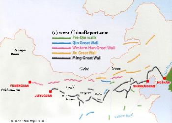
Map Great Wall China - Layers of Dynasties and Era's
A Schematic Map of China and East-Asia, with a super-imposed schematic of the various layers of the Great Wall of China.
Features Pre-Qin Dynasty Wall, Qin Dynasty Wall, Western Han Great Wall of China, the (Northern) Jin Dynasty Great Wall and finally the Ming Dynasty Great Wall as mainly remains today.
Main Features are Names and locations location of Passes on the Great Wall of China, outer layer and inner layer. Includes Shanhai Pass, Huangya Guan (Yellow Cliff) Pass, JiYunGuan Pass, Ningwu Guan Pass, Pingxin Guan, YaMen Guan Pass, Pian Guan Pass, JiaYuGuan pass, YuMen Guan Pass (Jade Gate) and Yang Guan Pass.
Further included for reference are City names, geographical features of landscape and main mountain ranges. Updates occur several times a year adding new pass locations and photo-virtual tours of Passes throughout China.
The finding of historic remnants of both Pre-Qin Dynasty Era and Qin Dynasty Era (221 BC - 207 BC) defensives walls very near current day Zhangjiakou, gives proof that in the time just before
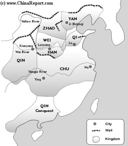
Schematic Map of the Main Ducal States during the Warring States Period. As depicted several States have built defensive walls along borders, the later foundations of the Qin Dynasty Great Wall of China (Wanli Chang Cheng)..
and during the reign of Emperor Qin Kalgan was already border station and likely a trading town as well. As legend has it, during the shortlived reign of the now vilified Emperor Qin (Reign: King of the State of Qin from 246 BC to 221 BC and Emperor of Qin 221 BC - 207 BC), the various Walls of China were supposedly unified for the first time, making of Zhangjiakou a true Pass City of the Great Wall of China. This was however but a brief and early moment of glory as it said that most of the Qin Dynasty Wall crumpled into dust within a few decades.
Between the years 386 AD and 534 AD, most of today's north China (P.R.C.) fell under the sway of the powerful Tuoba Wei or Northern Wei Dynasty. Initially, the Northern Wei Capital was situated at Datong in northern Shanxi Province and due west of Zhangjiakou. However, in the year 494 AD the northern Wei Capital was moved southward to Luoyang (in current day Henan Province) a safer location across the Yellow River (Huang He).
Another historic mention comes many centuries later when it is recorded that what today is the southern Zhangjiakou Region had been divided into two shires by the rulers of the Sui Dynasty (581 AD - 618 AD) and has brought into the administrative system of the central regime of China.
the subsequent fragmentation of the central Chinese Empire the northern regions fell out of Chinese control. In the beginning of the tenth century the Khitan People, moved out of their pasturelands in Mongolia heading for territories in the Bohai Sea regions of northern China (the north China plain). In 907 AD, the established their Capital in what today is the city of Beijing. In so doing, Beijing became an Imperial Capital for the first time (Read more in: "History of Beijing (Part 1 to 4)" or "History of the Yellow River (1 to 9)".
Between the years 1000 and 1009 AD, the Khitan Liao Dynasty (契丹國 ; 907 AD - 1125 AD) further expanded its influence over northern China, decisively defeating Song Armies in current day Hebei Province (Hopeih) and neighboring Shanxi Province. As a result the regions in which today lies the city of Zhangjiakou felt under the sway of the previously nomadic Khitan people, who nevertheless adopted various Chinese cultural traits, script and technical knowhow. Thereafter the Khitans reigned for another century leaving various Temples and Pagoda's in the regions (Beijing, Datong, etc) as a reminder of their achievements. Ultimately however, the Liao Dynasty was destroyed by another arising tribe, the Jurchen people of the Jin Dynasty who took the Liao Dynasty Capital at Beijing in the year 1125 AD. With the Jin capture of Liao Emperor Tianzuo the Liao Dynasty formally ended, however, remnants of its people, led by one Yelü Dashi, fled westward and eventually established the Western Liao Dynasty, also known as the Kara-Khitan Khanate, which ruled over parts of Central Asia for almost a century before being conquered by the Mongolian armies of the legendary Genghis Khan. At the same time, the Song Dynasty held on to more southern territories while the Tanguts (Chinese: Xixia = Western Sunrise) ruled in Ningxia (The Ningxia Plain of the Yellow River), Inner Mongolia, parts of Gansu and other western lands.
After the demise of the Liao Dynasty Zhangjiakou lay in the nortern territories which had been joined under the Jin Dynasty (1115 AD - 1234 AD). In August of the year 1211, in what has become known as the "Badger's Mount Campaign", Mongolian leader Genghis Khan led a 90,000 strong force southward to the border at Zhangjiakou in order to attack and crush the Chinese Jin Dynasty. Breaking through or simply bypassing the Jin Dynasty versions of Great Wall defenses the highly mobile Mongolian troops destroyed the 450,000 strong Jin Dynasty army on their way to further conquests in China and throughout Asia. It was the historical incident that earned the Zhangjiakou its Mongolian nickname as "Heaven's Gate", for beyond lay the untold riches of the Chinese farmers with their sedentary lifestyle and their cities filled with gold and wealth. To the often destitute Mongolian Nomads it was indeed a "Golden Gate". The capture of Zhangjiakou in this campaign was only the beginning of a lenghty war in which the Mongolians would eventually conquer all of the Chinese Culture territories, establishing the Yuan Dynasty in 1271 AD with its Capital at Khanbalik (Also: Dadu ; Beijing).
Zhangjiakou in the Ming Dynasty:
In the year 1368 AD the Mongolians of the Yuan Dynasty (1271 AD - 1368 AD) were driven out of China and pushed beyond the psychologically important line of the Great Wall of China, allowing for Zhu Yuanzhang the leader of the Ming (and Red Turban) Rebellion to establish the Ming Dynasty. Although, initially the focus of the new rulers lay in establishing firm control of the Chinese heartlands and the first Ming Capital was established in Nanjing in southern Jiangsu Province, it was during the Ming Dynasty Era (1368 AD - 1644 AD) when Zhangjiakou for the first time gained a true prominence as part of the heavily fortified border and the Great Wall of China as we know it today.
Although not much is known about Zhangjiakou specifically in this period, it is well known that after the Ming Armies had defeated a last important Mongolian stand at the Jiayuguan Pass of the Great Wall in the far west (current day Gansu Province), the borderlands with Mongolia became the scene of many a battle. While the war on the remaining Mongolian forces was still active and the front still fluctuated a number of border stations were heavily fortified against a return of the Mongolian threat. Later on, throughout the various reigns of the Ming Era, the defenses of these border stations would be further improved upon, creating over the centuries the supposedly continuous stone wall that has become precious world heritage today.
As for the case of Zhangjiakou, in the first reign period of the Ming Dynasty (Hongwu Reign ; Zhu Yuanzhang, 1368 AD - 1398 AD) it became an integrated part of the Ming Empire as part of the all important Northern fiefdom of Yan.This name, based upon the ancient knowledge that once during the Warring Nations Period, the regions had been known as the Chinese Kingdom of Yan, became the personal realm and exclusive operating base of the "Prince of Yan", who was none less than the Prince Zhu Di. The Prince, keeping his Capital only some 200 kilometers from Zhangjiakou, at Beijing, and being well versed in the dangers of the Mongolian threat, set to work inproving the defenses of his realm almost immediatly. Naturally, this included the strategic town of Zhangjiakou, the notorious Heaven's Gate. No specific data is available on the town in this period but it was in this time that the foundation of the extensive defenses around Zhangjiakou were designed and built. Later on this line of defense would be improved upon.
It would go to far to repeat all of the history of that crucial period here, however after the death of Zhu Yuanzhang in 1398 AD, a civil war soon erupted, with two main rival princes vying for the Throne of the Ming Empire. In the south seated in the Capital Nanjing this was the true and legal Emperor, Zhu Yunwen (Jianwen Reign 1398 AD - 1402 AD) a Grandson of Zhu Yuanzang. In the north however, one of the immediate Sons of the dceased Emperor, Zhu Di - the Prince of Yan, militarily a strong competitor -, arose in rebellion.
In short, the rightful successor of Zhu Yuanzhang was disposed of by military means and in the year 1402 AD the Prince of Yan managed to usurp the Throne, gaining political and military control of a now restless but solidified Ming Realm.
Subsequently, the new Yongle Emperor, the northern Prince Zhu Di, apparently found his new Capital a place to uncomfortable and too unsafe for a prolonged stay and succesful rule and a momentous plan was set up to return him and his entire Government to his northern base in Beijing.
Naturally, it was giant project to move a Capital. The rebuilding of Beijing into what was to become the largest and most beautiful Capital City and Imperial Palace in all the world took almost twenty years, being completed in the year 1420 AD and officially opened on the first day of the Lunar New Year of 1421 AD. With the completion of the national Capital of the Chinese Ming Dynasty at only some 200 kilometers away and with it the birth of the "Forbidden City" Palace, Zhangjiakou truly became a "Heaven's Gate" starting it off on path a rising military and economic importance.
The first version of the Dajing Men of the Great Wall of China in Zhangjiakou was built in the year 1458 AD during the Shunzi Reign of the Ming Dynasty. Founded upon remains of an earlier Great Wall of China constructed during the Northern Wei and Northern Qi (386 AD - 577 AD) Dynasties, the 9 meter wide gate formed the outer and front line gate of the Pass City and the "Middle Kingdom".
- Under Editing -
The heaviest earthquake to hit Zhangjiakou in the last 15 years measured 5.7 on the Richter scale. It struck at the end of the year 1997. In the aftermath of the earthquake Oxfam Hong Kong's started a relief program for earthquake victims in Zhangjiakou Prefecture. After one day transport by train from Datong City, the neighboring "Coal Capital of the North", on Monday January 19 of 1998 distribution of coal started in Dahe Township of Zhangbei County and also in Kangleng Township of Shangyi County as due to the enduring winter cold this was identified as the most urgent need in these most effected area's. The coal was intended to be used as fuel for keeping warm and cooking.
As rescue operations continued temperatures dropped to minus 30 Celsius with heavy snowfalls continuously hampering both transportation and the distribution of relief materials. In its report Oxfam mentioned that as the programme officer moved into even more remote areas in the counties of Zhangjiakou Prefecture keeping up regular communications wass getting increasingly difficult. This was presumably due to the mountainous terrain and the fact that telephone lines had been cut. No mention is made of any
casualties.
Except for the coal, other relief materials were locally available and were therefor purchased from nearby towns around Zhangjiakou City where possible. These items included wooden planks, nylon sheets and other materials for building shelters are being distributed in the two townships since Tuesday. Not much later additional relief items - grain and fertilizers for spring farming were distributed around the time of the Chinese New Year. In the period since, over 20 smaller and larger quakes are recorded in the wider regions of Zhangjiakou- Beijing and Datong each year.
In the summer following the 1997 earthquake, Zhangjiakou was the setting for Zhang Yimou's film Not One Less (1999), a modern rural drama in which a rural teacher travels to the city in search for one of her students, lost. Among things the film accurately shows the arid scenery found in some of the villages in the area.
On September 7 of 2005 the new expressway linking Beijing via Zhangjiakou to Ulanqab (Jining) in Inner Mongolia and territories beyond was officially opened adding another key road to make Zhangjiakou into a logistics and manufacturing center for the larger hubs of Beijing and Tianjin.
On August 6, of 2012 the word went out to the world that there had been a bad early morning collapse of the famous Da Jing Gate of the Great Wall of China at Zhangjiakou. The next day in the afternoon, the news office of Zhangjiakou City People's Government issued a statement on the "big door of the Great Wall collapse" issue telling that a part of Da Jing Gate, a "Key Protected Cultural Relic", had collapsed as a result of the unusual rainfall. The news went unreported internationally, but the unusual rainfall in Beijing at some 200 kilometers which flooded and wrecked large parts of the suburban area's received worldwide attention. In Beijing a relatively high number of people were drowned as a result of the flooding.
In the aftermath it has become clear that a section of wall immediatly adjacent the Da Jing Gate had fallen down exposing a 30 meter wide gap. This is roughly the same section that had fallen in 1995 but had been "restored" the next year. uckily, because the collapse occurred early in the morning during dreadful weather, no tourists and residents were present within the scenic area and thus the accident caused no casualties. The record breaking downpours of the wet season, coupled with the construction of a plaza outside of the Gate (on the Mongolian side), were blamed as reasons for causing the damage.
In 1900 AD Kalgan lay on the flight route of the Empress-Dowager Cixi and her captive, the Guangxu Emperor. Fleeing Beijing after a foreign invasion by the 7 allied Colonialist nations the core of the Qing