The Zhangjiakou Report is part of the overall website www.ChinaReport.com & www.drben.net
Learn about what is new on this Site from below window.
ChinaReport.comat
There are few historic landmarks in the City of Zhangjiakou.
First among the true ancient relics of the city is its Temple, the Liuping Si with its standing stone pagoda. The other major landmark is the heavy Ming Dynasty Era (1368 AD - 1644 AD) City Wall of the Pass City of Zhangjiakou. A third historic landmark the Qingyuan Tower, an impressive former gate topped by an intruiging wooden pavilion, is found in the Xuanhua Township due south-west of Zhangjiakou City proper. As with several other towns surrounding the main fortified Pass City and Gate of the Great Wall of China known as Zhangjiakou, the defenses of this crucial defense area was further enhanced by fortifying all towns in surrounding minor passes leading down to the Qingshui River valley and Zhangjiakou proper. The town of Xuanhua was such a town. Heavily fortified it formed both a gate inside the wide Yang River Valley, the fortification of this town in particular served to defend the rear of the main Fortress at Zhangjiakou.
DA JING GATE:
According to seasoned travelers and fans of the Great Wall of China, the first Landmark anyone should visit within the city of Zhangjiakou is the so-called "Da Jing Men", the Da Jing Gate of the Great Wall of China situated on the northern end of the city along the valley of the Qingshui River.
The main reason for its importance is that the Da Jing Men forms a unique section within the Great Wall due to its early origins and is is considered the "original gate" or first gate of the later well fortified pass city. The second important reason to start your visit to Zhangjiakou City off with a visit to this great historic gate is simply that - in the Chinese mind of the times at least - Zhangjiakou was synonymous with the Great Wall, and vice versa the Great Wall was synonymous with the all important Pass City of Zhangjiakou in these regions.
With the construction of the Da Jing Gate in the year 1458 AD, the front line in the continuous border war with the hated "Barbarian" tribes who had been driven out not too long ago (Yuan Dynasty) was fortified and made even more impenetrable and forbidding than it had been previously. Thereafter, the solemn and impressively solid Gate as well as the "coiling scaled dragon" visible along the mountain ridges presented an awkward reminder of the Chinese military power of which the town was the main dispensing point in these territories. Thus the Da Jing Gate, truly became the "Heaven's Gate" in a phsycial form. After 1458 AD, Da Jing Men posted along the shortest route from Mongolia to Beijing was the front door of China, a front door which at all costs should be kept shut before any barbarian foreigner who wished to enter the (superior) "Middle Kingdom".
On the other hand, from the Mongolian Tribal point of view the Da Jing Men became the most prominent obstacle and over time Zhangjiakou became the "Gordian Knot" which the Mongolian raiders had to untie, before they could have a hope of advancing on the Chinese Capital.
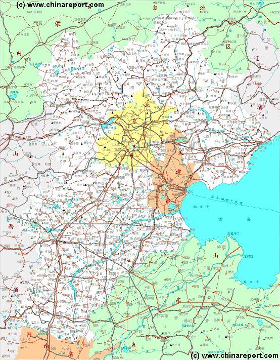
The Dajing Gate of the Great Wall of China can be found just a short distance travel due north of the urban sprawl of Zhangjiakou City along S242 Provincial Road and the eastward curve of the Qingshui River. The Dajing Gate was built inside the Dashuigou which is also the Qingshui River Valley.
During the early Ming Dynasty the town of Xuanhua situated due to the south east of Zhangjiakou along the Yang River valley evolved into a Walled City itself. Positioned in the rear of the larger Pass City of Zhangjiakou, Xuanhua was a fortified town which served as a reserve garrison for the defense of Zhangjiakou and the Great Wall of China sections in its vicinity. As a result, much of the town is still surrounded by ruins of its Ming Era city wall.
Qingyuan Tower of Xuanhua Town:
Another interesting remnant of the extensive defenses of the Great Wall of China within Zhangjiakou Prefecture is the so called Qingyuan Tower, an impressive former gate topped by an intruiging wooden pavilion, is found in the Xuanhua Township the main population center of Xuanhua County.
Museums:
Zhangjiakou Museum, situated west of Peoples Park.
Address:
No.21 Xiaohetao, Qiaoxi District, Zhangjiakou 075000, China
Parks:
- Peoples Park, situated on the east bank of the Qingshui
River smack in the middle of Zhangjiakou.
- Shengli Park in the east of Zhangjiakou city.
- Shiquan Park, a small park along the east ring road due
north of Jiaotong Ecological Garden.
- Xincun Park in the western central city on the west bank of
the Qingshui River.
- Zhangjiakou Xiaobaishan Ecology Park in the north-west of
the city.
- Jiaotong Ecological Garden. North-west city.
- Jinhekou Forest Park.
CEMETERY:
- Shishanli, east city, inside of East Ring Road.
This page was last updated on: May 14, 2017
My Great Web page
ZHUOLU:
Longfu Si, north of Zhulo Town center along S342 Provincial Road, due south of its intersection with the large G7 Jinzhang Expressway (the main Beijing to Zhangjiakou Highway).
Gao Temple (Gao Miao); found between Zhuolu Town and the Yang River (Yang He).
SHURI KANNONDO TEMPLE:
Shuri Kannondo Temple and Temple village are situated in rural parts of south east Zhangjiakou Prefecture, along X412 County Road which leads north east out of Xiahuayuan Town.
DRAGON SPRING TEMPLE:
WUHUA MEADOW:
The Wuhua Meadow is another prairie and grasslands area which has been protected and which has become a popular tourist destination. It is found in Guyuan County of Zhangjiakou Prefecture.
LIGHTNING RIVER WETLAND PARK:
The Lightning River Wetland Park is considered to be number one scenic zone on the highlands along the southern edge of the Mongolian Plateux in Hebei Province. With its astounding natural beauty and unique scenery for these regions it is no doubt also the best preserved highland wetlands area closest to China's capital Beijing.
LITTLE WUTAI MOUNTAINS:
Little Wutai Mountain Nature Reserve is a comprehensive tourist destination boasting forest parks, gorges, crags, peaks, caves, and strange stones that worth of exploring.
CUIYUN SHAN SKI RESORT:
Cuiyunshan Skiing Resort is a perfect winter resort located in the Heping Forest Park situated at some 60 kilomters driving from Zhangjiakou. Posted on Cuiyun Mountain there are currently six different slopes to choose from. The skiing season is betwen (half) November, depending on snowfall, to March the next year.
Apart from skiing there are a variety of other resort type activities to choose from for your entertainment.
WANLONG SKI RESORT:
Zhangjiakou Wanlong Ski Resort is situated at a short distance due south west of Cuiyun Shan Ski Resort. Visitors can stay over at the Shuanglong Hotel which lies on the eastern sideof the resort town.
WOLONG SHAN AMUSEMENT PARK:
The Wolong Shan Amusement Park can be found situated due north-east of Zhangjiakou city proper in a town named Chongli. It is found near Cuiyunshan Ski Resort and situated along the east side of the Qingshui River and along S242 Provincial Road at some 60 kilometers driving out of Zhangjiakou.
To Get here: First find the S242 Road which leads past the Da Jing Gate of the Great Wall of China. After locating Da Jing Gate drive on for several kilometers on S242. Road signs will show both Zhangjiakou Wanlong Ski Resort and Wolongshan Amusement Park. Follow the signs but drive past the exit towards Wanlong Ski Resort and remain on S242 Provincial Road. After half a kilometer the Amusement Park comes into view.
Other travel options include the Bus Line to Chongli Village and its Bus Station. It is a well organized route however the Bus station is situated at the center of town (north of primary school) whereas the amusement park lies at the north end. Ask the Bus Driver to take you little bit beyond and get off at the Holiday Inn Hotel and the Resort.
Hotel Options include the on site Chongli Dream Holiday Inn "Special Fountain".
Other scenic spots of the Region: Yunquan Temple, Woniu Mountain Scenic Area, Water Villa.
GREAT WALL OF CHINA AT WANQUAN AND DASHUIKOU:
As described in more detail in our section "Great Wall of China in Zhangjiakou Prefecture", during the Ming Dynasty when the last version of the Great Wall of China was built in stone, Zhangjiakou served as a highly important "Pass City" (a huge fortress serving as a border gate as well) while at the same time, the length of the Great Wall extended to the east and to the west of it. Noteably, there was not just one Great Wall, but in fact no less than 3 "Layers" of the Great Wall of China in sequence were constructed for defense and traverse the wider regions.
Although not many tour operators (not even regionally) focus on this fact, this means that ruined remains of the Great Wall of China can be seen and found throughout Zhangjiakou Prefecture's rural area's and beyond. The main tourist magnet of Zhangjiakou is the Gate to the Great Territory (Da Jing Men), which in ancient times (well into the 20th century) formed the front gate of the city and also of the Chinese Territories.
However, what is not made clear to most visiting tourists is that in fact, this claim of being the outermost door is not entirely correct. An outer layer of the Great Wall of China curves around Zhangjiakou and passes well north of Da Jing Men. Thus, in reality, the outermost front gate stood at a small town today known as Shanfangbu ( north of Wanquan) where it can still be visited. It is an under advertized site which means that anyone interested in doing so will have to make their own way to the location.
The outermost layer of the Great Wall of China in Zhangjiakou Prefecture comes from the west and curves up and around the pass city of Zhangjiakou to reach Shanfangbu. From this position due north of Zhangjiakou City it winds its way in a north eastern direction climbing into the mountains. Ultimately, although hard to trace and no longer continuous, it connects to the Great Wall section of Dushikou. Dushikou is situated far to the north east of Zhangjiakou city in rural and mountainous terrain and a remote but excellent place to explore a "rough section" of the Great Wall of China.
Other interesting remains of the defenses arranged in the area are found at Xuanhua Town situated along the Jinzang Expressway to Beijing, due south east of Zhangjiakou city.
A Full Google Earth Supported Map Overview of All Structures of the Great Wall of China from East to West, by DrBen.Net (c) ChinaReport.com and Google.com.
The Dragon Spring Temple (Longchun Si) is situated at quite some distance (30km) south east of Zhangjiakou City where it is situated on the northern slope of the Jiantou Mountain.
To Get There: Follow G207 highway to the town of Zuowei Zhen. In Zuowei Town, turn westward onto X454 County Road. Follow X454 past the local Amai Golf Club until reaching a small town known as Diliu Tun (Xiang). At Diliu Tun follow the main road southward towards the mountains. At the very end of it stands the Dragon Spring Temple.
BASHAN PRAIRIE:
Another main scenic site within Zhangjiakou Prefecture are the now much whithered Bashang Prairies situated in Zhangbei County. In history the Bashang Prairie was one of the several hunting grounds of the emperors in Qing Dynasty (1644 AD - 1911 AD) in the regions surrounding their Capital Beijing. Although until the end of the 20th century a place of extraordinary natural beauty and pristine prairie landscape. More recently, the Bashang Prairies have fallen victim to a rampant wave of mass tourism followed by a burst of development projects in the area. Already a fragile eco-system under severe stress from drought, advancing deserts and effects of pollution caused upwind, reportedly the Prairies have been unable to cope. Still advertized as the perfect getaway for the city middle class, party affiliated rich, or anyone else willing to buy, development projects have taken over and established a "resort stay" market on the Bashan Prairies.
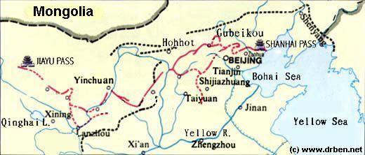
China Report - Map of the Great Wall during the Ming Dynasty
Satellite image of China and North-East Asia, with a super-imposed schematic Map of the location and Path of the Great Wall as constructed during the Reign of the Ming Dynasty. Included for reference are City names, geographical features of landscape, Names and locations of Passes on the Great Wall of China.