City Prefecture of Nagqu - 450.000 sq Kilometers (?? sq miles)
Population: The Total Urban Population of Nagqu Prefecture is less than 400 thousand with the far majority, by latest count 331 thousand living in the now city of Nagchuka. Main Chinese migrants have recently settled in town as over recent years it has grown to be the central modern logistics center of all civilian and military operations within the Tibet Autonomous Region.
The town of Nagchuka is an originally small Tibetan Town situated due north of the Tibetan Capital of Lhasa at a distance of around XXX miles. The town is situated near a series of minor Lakes among which the largest, the Lake Nam (Nam Co) is renowned as one of holy lakes of Tibet.
In modern times Nagchuka has been connected to the outside world by means of the modern Golmud to Lhasa Highway designated as the G109 National Road, along which further to the north along the G109 National Road lies the nearby town of Amdo. In addition, a second road, the G317 National road leads eastward away from the town, connecting Nagchuka with the Tibetan Town of Qamdo in the neighboring Qamdo Prefecture.
Up till as late as 1960 but a small and remote town situated within the rugged hinterlands of the central Tibetan territories - a domain almost exclusively reserved for Tibetan nomadic herdsmen, their families and lifestock as well as an astounding abundance of wildlife, Nagchuka has relatively few historic landmarks or monuments and few or no tourist attractions. Most outsiders who pay a visit to Nagchu today do so while passing through along the highway, headed to the scenic Nam Co Holy Lake, which is the largest inland salt water lake found within the Tibet Autonomous Region and also counts as the highest elevation salt lake in the entire world.
Other than the Nam Co Holy Lake and the stunning vastness of the landscape, the main attraction of Nagchuka is its historic and renowned Shodain Monastery, a place which no doubt has seen a turbulent recent history. Nagchuka is also renowned for its many hot springs and geothermal hot spots. It yearly hosts the Nagqu Kyaggen Horse Race , a colorful native event that draws in the crowds from afar.
Landmarks of Nagchuka are but a few. The main historic attraction of the town itself is its renowned Shodain Monastery.
Other historical and cultural sites mentioned are the Yamtung (Chinese: Zhanzhung) Cultural Site and the "Bon Monasteries" of Nagchuka, refering to the ancient pre-Buddhist beliefs embodied in the Bon Religion of early Tibet.
Otisde of town, the Lake Nam, highest altitude slat water lake in the world and so also in Tibet is the main scenic destination for visiting tourists and travelers. A much more distant but equally spectacular sight is the Siling Co (Lake Siling) which lies well west of Nagchuka proper.
Last but not least should be mentioned the stunning landscape of Alpine grasslands, locally known as Changtang grassy plain. Studded between the grasslands are (orinigally) a multitude of ponds and lakes as well as occassional bubbling pools, the scenery more or less and extension of the "Starry Sea of Amdo" - which is the source region of the Yellow River found further north upon the central Tibetan plateaux. Embued with a rich wildlife and unique forms of vergetation, the Nagchu(ka) Prefecture is of great interest to nature photographers and others with a particular interest in eco-tourism. Most eye catching species found in Nagchuka Prefecture are the wild Yak, the wild Tibetan Ass (Donkey) and of course the Tibetan antelope, all 3 highly protected species.
A Full listing of Nagqu Town, County and Prefecture Landmarks, Monuments, Hotspots and other sites of importance in alphabetical order. Search through the list to find your Full Report and Photo-Virtual Tour of each monument or landmark within the City, or Region of Nagqu in Tibet Autonomous Region of China (PRC).
Public Transport in Nagqu
The Main and only Railway Station of Nagqu is - no information available.
ROADS IN NAGCHU:
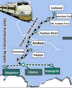
Nagqu is connected to the main cities of Lhasa and Golmud via the G109 National Road. In addition the town of Nagqu is connected to the G317 National Road leading eastward to Qamdo. Only a secondary road leads eastward, spliiting off the G109 highway at some distance due north west of Nagchuka Town. This secondary road is the S302 Provincial Road which leads past the local Pung Co and Bam Co (Lakes) before meeting the much large Siling Co much furter along, at distance well away from Nagchuka.
Nagqu has a Railroad Station which is part of the "Tibet Railway".
Nagqu is a - no information available.
Today Nagqu is the most important logistics and supply center within the Tibet Autonomous Region. Well served by both the the Beijing to Lhasa "Tibet Railway" and an international airport (with dual service as miltary airport) in 2014 the town is one of the booming population centers within the Tibet Autonomous Region and the town is relatively frequently visited by both Chinese and International Travelers and tourists.
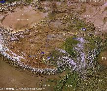
Tibet-TibetanPlateaux-SatelliteImageOverview 1A
A SatelliteImage overview Map of the entireTibetanPlateauxincluding parts of bordering regions of Xinjiang-UyghurAR, Gansu Province, NingxiaHuiAR, Inner-MongoliaAR,Sichuan Province,andYunnan Province. Surrounding nations and Territories are: Myanmar (Burma), Bhutan, Sikkim, Nepal, Bangladesh, India, Kashmir and Pakistan.
This Map clearly defines Provinces and Regions, main mountain ranges, main rivers & lakes of the region, locations of main cities and landmarks.