The Kyrgyzstan Maps Index gives acces to all Maps relevant to Kyrgyzstan and Kyrgyz Nationality enclaves in Central Asia, and Area's of Specific Interest within that Region, as used and/or produced by KyrgyzstanReport.com. Please use these Maps to find your way easily around the Province, Cities, Area's and many Monuments & Landmarks.
Map of the Ancient Silk Road during the Han Dynasty & Roman Age 2
A Schematic Map depicting the Full Length and main pathways of the Ancient Silk Road during the Han Dynasty Period (206 BC - 221 AD) and Roman Age (30 BC - 630 AD).
In 30 BC the Roman Empire started trading with India, which was already well known from the
Conquest of Alexander the Great (+/- 330 BC). In the following 6 centuries the West would Trade with India and indirectly also with China through the Silk Road. The Silk Road only lost its Value after the European Age of Discovery and the Establishment of Maritime Trade Routes with India (16Th Century) and later China. The Yellow River is crossed at Lanzhou, after which Dunhuang is the Last Station in China.
Map of the Ancient Silk Road during the Han Dynasty & Roman Age 1
A Schematic Map depicting other details along the Full Length and main pathways of the Ancient Silk Road during the early Han Dynasty Period (206 BC - 221 AD).
As seen from China the Silk Road extends due Westward from Chang'An (Xian) the Han & Tang Dynasty Capital. The Yellow River is crossed at Lanzhou, after which Dunhuang is the Last Station. This
Map depicts the Lost Civilizations of Loulan and Hotan, as well as the south route and north route of the Silk Road coming together at Dunhuang in current day Gansu Province of China.
Geographic Maps of the main Silk Road Path, maps of Silk Road byways, the Routes of Monk Xuanzang and Marco Polo in Central Asia, and various other historic maps and journeys.
A Full Google Earth Supported Map of Kyrgyzstan by Google.com.
Asia Report introduced on Levels of its Online Publishing's in April of 2009, first including Gansu Province of China.
Find Google Maps on nearly all Report & Photo Pages where appropriate and useful.
Adjacent Map gives direct access to Map Of Kyrgyzstan by Google.
Map Yuan Dynasty Mongol Empire in Time 1206 AD - 1294 AD
A Schematic Map of the Mongol Empire of Genghis Khan (TeMuJin) and descendants through its several stages of conquest in its short but Impressive Existance in History. Timeline depicts the Mongol Conquest starting in the Year 1206 AD, when Genghis Khan first united the Mongol-Turkic Tribes of Mongolia and Lake BayKal becoming Great Khan. The Timeline continues through the year 1219 AD, the year 1223 AD taking Transoxiania, 1227 AD, 1237 AD when the Northern Jin Dynasty of China was annihilated, 1259 AD conquering ancient China above the Jiangste River and 1279 AD when all of China was taken and the Yuan Dynasty established under the Kublai Khan. Last is the Year 1294 AD when the Mongol Empire reached its largest geographical size and Zenith, 22% of world land area, but through lack of central leadership and over-expansion fragmented into 4 large parts, then imploded upon itself.
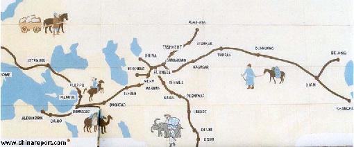
Asia Report - Map Trade Routes in Asia in the 13Th Century
A Schematic Map of the Eurasian Trade Routes existing in the 13Th Century. Clearly marked in Red Accent on the Map are the cities of the network of land-bound trading routes through Central Asia known as the Silk Road (the path of Marco Polo and others). Marked in Blue Accent are the Main Ports and Harbors of the Maritime Trade Routes that operated between the Arabian Peninsula and the Red Sea, the Indian Ocean and Coastal Cities, the Straights of Malacca, the South-China Sea's and beyond. As shown Maritime Trade to China mainly entered through Southern Harbors, then was distributed internally by use of the Grand Canal, the Yangtse River and the Yellow River.
Map includes the Route travelled by Marco Polo, William of Rubruck and John of Pian de Carpine, the three famed European Travelers of the Time.
Locations of Main Trading Ports and Cities on Trade Routes of the Time are marked.
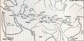
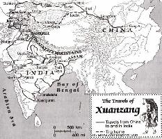
This Schematic Map shows the entire "Journey to the West" as made by the Chinese Monk Xuanzang in the years 629 AD to 645 AD.
The Path of the Journey to India led though China, Kyrgyzstan, Tajikistan, Afghanistan, Pakistan and India. The Return Journey led through Pakistan and Afghanistan to reach Kashgar in current day Xinjiang-Uyghur Autonomous Region of China. Because the (Han) Chinese Cultural Zone during the Tang Dynasty Era only reached as far as Dunhuang, where the Great Wall began, Xuanzang had to travel south-east from Kashgar via Yarkant and Hotien (Khotan) along the South Route around the Taklamakan Desert to finally return to his native China in 645 AD.
Map - Travel Route of Xuanzang - Journey to the West
A Schematic overview Map of Xinjiang-Uygur Autonomous Region entire and large parts of neighboring Nations of India, Pakistan, Afghanistan, Tajikistan, Kyrgyzstan and Kazakhstan, Russia, The Republic of Mongolia, as well as Chinese Provinces and Territories of Inner-Mongolia AR, Gansu Province, Qinghai Province and Tibet Autonomous Region.
This Map Includes Cities and Towns (shown by size), Main Monuments & landmarks of Xinjiang AR, the Taklamakan Desert in South-Central Xinjiang AR, major highways, provincial railroads, a variety of border passes in the Karakoram Mountain Range and the Tian Shan Mt. Range, plus main waterways, rivers and lakes of this large region.
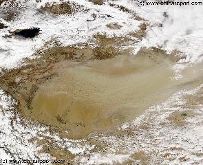
China Report - Map o/t Taklamakan Desert & Tarim River Basin 2a
A Second Satellite Image Map of the entire Taklamakan Desert and the Tarim River Basin in Xinjiang-Autonomous Region of Western China.
During the Time this Image was taken it was early spring; Mountains were snowcapped and a dust storm is blowing in the Central and Most Arid Regions of the Tarim River Basin.
Map gives explanation and backgrounds to Local Geography, the Flow of the Tarim River from the Pamir Mountains in the West to Lop Nur (Dry) in the East, ancient Oasis Cities of the Tarim Basin and Taklamakan Desert, the North and South Routes of the Silk Road in this Area, Past and Current Climate and Historic Backgrounds.
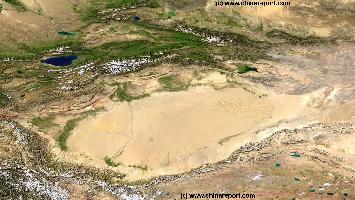
China Report - Map o/t Taklamakan Desert & Tarim River Basin 1A
A Satellite Image Map of the entire Taklamakan Desert and the Tarim River Basin in Xinjiang-Autonomous Region of Western China.
Map gives explanation and backgrounds to Local Geography, the Flow of the Tarim River from the Pamir Mountains in the West to Lop Nur (Dry) in the East, ancient Oasis Cities of the Tarim Basin and Taklamakan Desert, the North and South Routes of the Silk Road in this Area, Past and Current Climate and Historic Backgrounds.
Satellite Images used as Maps; Xinjiang-Uyghur AR, Taklamakan Desert, Tian Shan, Karakoram, Kunlun and other Mountain Ranges, Passes, tunnels, Tibetan Plateaux, Central Asia and parts there of.
Satellite Image based Maps of Kyrgyzstan
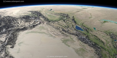
Asia Report - Map Image West Xinjiang AR & Central Asian neighbors
This Satellite Image provides a clear overview of West Xinjiang, Taklamakan Desert, North Pakistan, Afghanistan, Tajikistan, Kyrgyzstan, Kazakhstan and a large section of the (southern parts) Russian Federation.
Marked on the map for orientatation are the names of major National and Provincial Capitals, cities, several towns and villages, oceans, sea's, lakes and rivers, as well as mountains, national borders, and locations of interest.
Browse the map and follow the links to more information, maps and photos of each location.
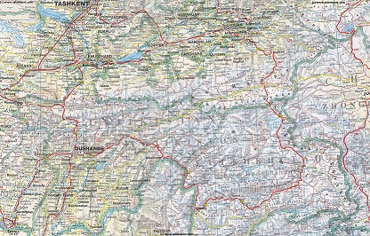
Asia Report - Road Map to Nations of Central Asia
A geographical and topographical overview Map of the Central Asian Nations of (South) Kazakhstan, Tajikistan, Kyrgyzstan, Uzbekistan, Turkmenistan, and Parts of North Iran, North Afghanistan, North Pakistan, North India (Jammu & Kashmir), and the region of Kashgar (Kashi) in West China's Xinjiang-Uyghur Autonomous Region of China.
Map includes International Borders, national provinces and regions (where possible), main cities and roads, main lakes and waters, as well as the locations of Historic Sites, wildlife reserves, officially designated ethnic autonomous communities, main mountain peaks with heights and more coming soon !
Browse the Map, click and follow the links to additional information on each site and location. Click on selected highlighted Map sections for a more detailed map of that Region. Explore the connections in central asia as never before !
Asia Report - Road Map to Tajikistan in Central Asia
A geographical and topographical overview Map of the Central Asian Nation Tajikistan, including area's of bordering nations of Uzbekistan, Afghanistan, Kyrgyzstan and Xinjiang-Uyghur Autonomous Region of China (PRC).
Map includes International Borders, national provinces and regions (where possible), main cities and roads, main lakes and waters, as well as the locations of Historic Sites, wildlife reserves, officially designated ethnic autonomous communities, main mountain peaks with heights and more ! Browse the Map, click and follow the links to additional information on each site and location. Click on selected highlighted Map sections for a more detailed map of that Region. Explore the connections in central asia as never before !
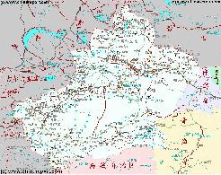
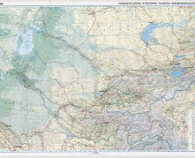
Asia Report - Road Map to Kyrgyzstan in Central Asia
A geographical and topographical overview Map of the Central Asian Nation Kyrgyzstan, including area's of bordering nations of Uzbekistan, Afghanistan, Tajikistan and Xinjiang-Uyghur Autonomous Region of China (PRC).
Map includes International Borders, national provinces and regions (where possible), main cities and roads, main lakes and waters, as well as the locations of Historic Sites, wildlife reserves, officially designated ethnic autonomous communities, main mountain peaks with heights and more ! Browse the Map, click and follow the links to additional information on each site and location. Click on selected highlighted Map sections for a more detailed map of that Region. Explore the connections in central asia as never before !
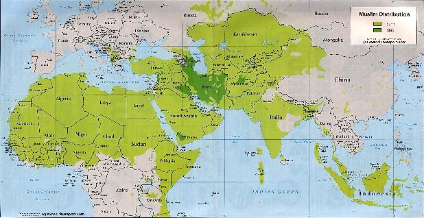
Asia Report - Maps - Distribution Islamic Faith Asia, Africa , Europe
A Demographic Map depicting the Distribution of the Islamic Faith in Kyrgyzstan and Asia, as well as Europe and the majority of the continent of Africa.
Sunni Islamic Areas are depicted in Green, whereas the Shia (Minority) Areas are depicted Darker Green.
The predominantly Muslim Nation of Kyrgzystan and parts of neighboring nations.
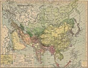
Asia Report - Colonialism - Growth of Colonies & Japan after 1801 AD
A Map drawing of the Eurasian continent , parts of North-East Africa and the Middle East in the 19Th Century between 1801 AD and 1900 AD. Focal points are the expansion of western colonial posessions of Portugal, Britain and France, as well as Russia moving from West to East. Labeled seperately is the later Rise of the Empire of Japan in the East.
Included in this Map are the main cities across the continent with their brief histories and events during the 19Th Century. Marked in Colors for clarity are the various colonial and imperialist Nations. As relating to China; special attention is payed to so called Treaty Ports. The First Treaty Ports were forced open by Britain in the year 1841 AD, but counted over 80 in total by the end of the 19Th Century. The most important Treaty Ports in China are marked and described with a short history where the map allows. Follow the links for more information on each location and subject.
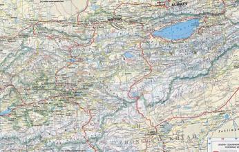
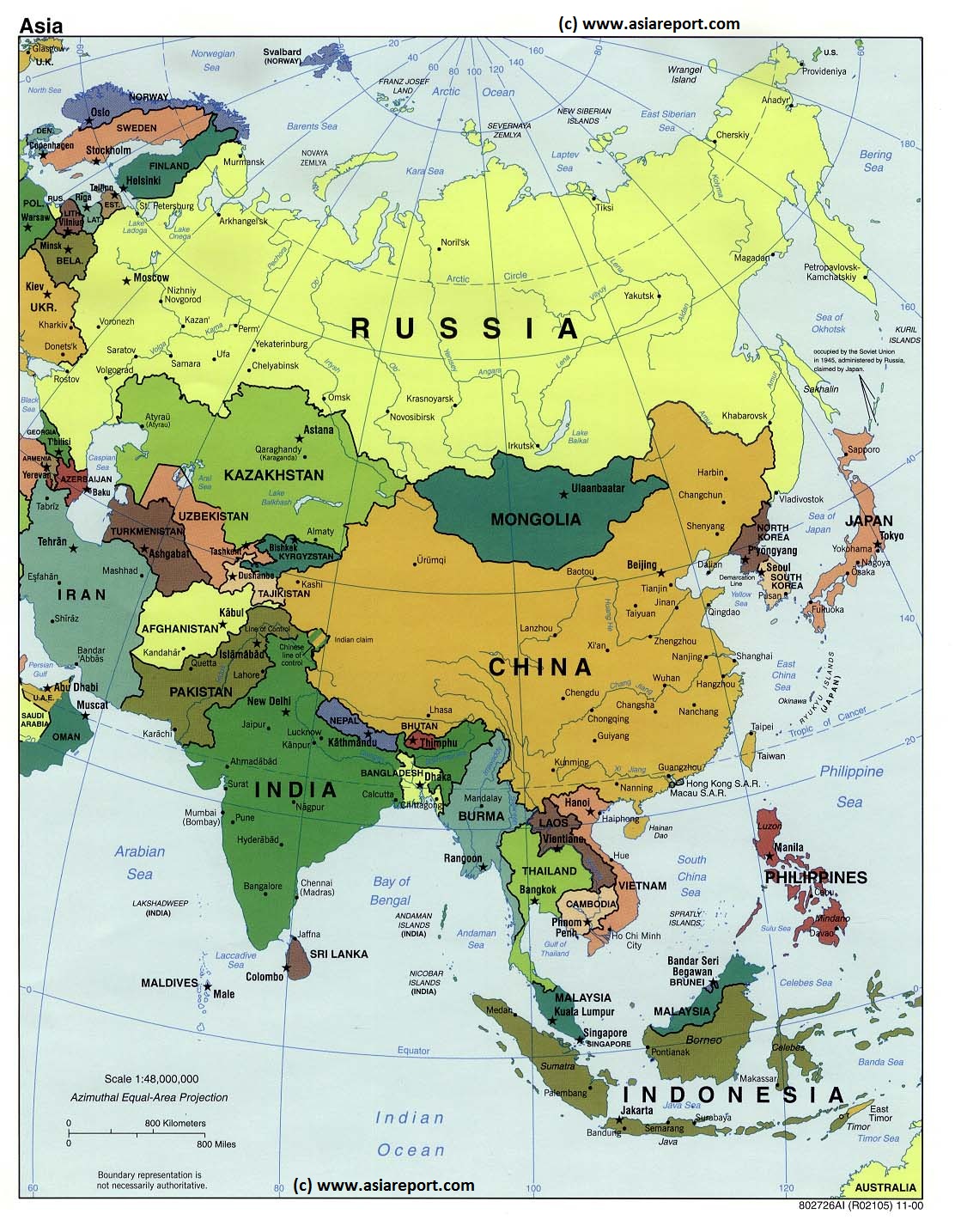
Asia Report - Map of Asia - Political: Mongolia and Bordering Nations of Asia
A Geographical overview Map of Asia entire depicting the current political borders of Asian nations, national Capitals and provincial Capital cities where possible.
This Map focusses on China (P.R.C.) and neighboring Nations of Central, North, East and South-East Asia with National Borders and National Capitals depicted and linked in.
Bordering Nations of the Peoples Republic of China are Bhutan, Nepal, India, parts of Pakistan, parts of Afghanistan, Tajikistan, parts of Uzbekistan, Kyrgyzstan, Kazakhstan, South-Central and Eastern parts of the Russian Federation including the Republic of Buryatia, the Republic of Mongolia, North Korea (D.P.R.K.), South Korea (R.O.K.), Japan, the de facto independent Island of Taiwan (Republic of China) and further the South-East Asian Nations of Vietnam, Laos, Cambodia, Thailand, MyanMar (Bhurma) and Bangladesh.
Map includes names of all Capitals of all 22 Chinese Provinces, Five Autonomous Regions (Inner Mongolia, NingxiaHui,Guangxi Zhuang, Tibet, Xinjiang), Two Special Administrative Regions and Four Muncipalities (Beijing,Chongqing, Shanghai, Tianjin).Disputed border regions, the Main Deserts of the Gobi and Taklamakan, steppes and basins, Rivers, Lakes, Sea's and Oceans are included.
- Please browse the Map and follow the links to futher information on each location and destination of your choice. -
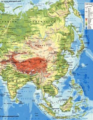
Asia Report - Map Geographic - Relief : Central, East & South-East Asia
A Geographical overview Map of Central, East and South-East Asia. This Relief Map depicts the Nations, Cities and main road and railroad connections.
This general Map focusses on the Republic of Mongolia, The Peoples Republic of China and neighboring Nations of Central, North, East and South-East Asia.
Bordering Nations of the Peoples Republic of China are Bhutan, Nepal, India, parts of Pakistan, parts of Afghanistan, Tajikistan, parts of Uzbekistan, Kyrgyzstan, Kazakhstan, South-Central and Eastern parts of the Russian Federation including the Buryatia and Khakassia Republics, the Republic of Mongolia, North Korea (D.P.R.K.), South Korea (R.O.K.), Japan, the de facto independent Island of Taiwan (Republic of China) and further the South-East Asian Nations of Vietnam, Laos, Cambodia, Thailand, MyanMar (Bhurma) and Bangladesh.
Map includes names of all Capitals of all 22 Chinese Provinces, Five Autonomous Regions (Inner Mongolia, NingxiaHui,Guangxi Zhuang, Tibet, Xinjiang), Two Special Administrative Regions and Four Municipalities (Beijing,Chongqing, Shanghai, Tianjin).Disputed border regions, the Main Deserts of the Gobi and Taklamakan, steppes and basins, Rivers, Lakes, Sea's and Oceans are included.
Please browse the Map and follow the links to futher information on each location and destination of your choice.
Xinjiang-Uygur Autonomous Region Satellite Map 1A
A Satellite Image overview Map of Xinjiang-Uygur Autonomous Region entire and parts of neighboring Nations of India, Pakistan, Afghanistan, Tajikistan, Kyrgyzstan and Kazakhstan, The Tuva-, Khakassia- and Buryatia Republic of the Russian Federation, The Republic of Mongolia, as well as Chinese Provinces and Territories of Gansu Province, Qinghai Province and Tibet Autonomous Region.
This Map Includes Cities and Towns (shown by size), the Irtush River Valley, the Dzungarian Basin of Xinjiang AR, the Taklamakan Desert in South-Central Xinjiang AR, a variety of border passes in the Karakoram Mountain Range and the Tian Shan Mt. Range, plus main waterways, rivers and lakes of this large region.
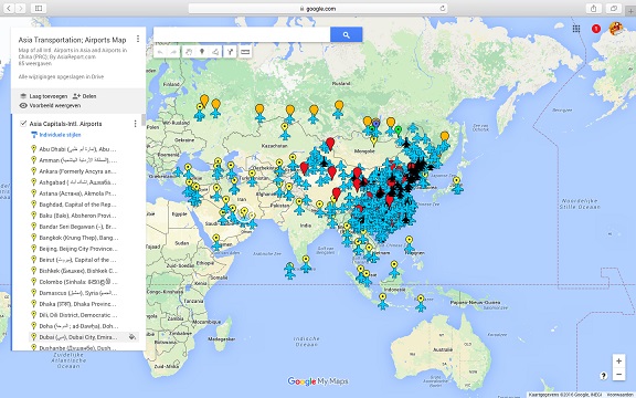
Asia China Mongolia Transportation - Airports & Railroads Satellite Map
This Satellite Image provides an overview of all International Airports in Asia, all Airports in China (PRC) and Mongolia. In addition all military airbases in China (PRC) listed.
Navigate map and click pins for additional information and video where available. Link through from any pin to location information and backgrounds.
Overview all transportation in the Peoples Republic of China and additional Asian Nations in one glance.
Direct Hotel & Resort booking + additional packages linked by location across China, Mongolia and neighboring Asian Nations.
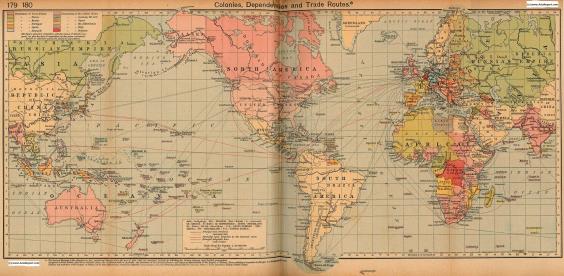
Colonialism - 1912 World Map Colonial Possessions & Trade Routes
A Map drawing of the World depicting the Colonial Possessions as they were distributed in 1912 AD. Superimposed and marked in colors are subsequent changes in Influences spheres, colonies and possessions due to World War I ( 1914 AD - 1918 AD). Further included in this Map are the main cities across the continents with brief histories and events during the late 19Th Century and early 20Th century, where relevant. Marked in Colors for clarity are the various colonial and imperialist Nations. As relating to China; special attention is payed to so called Treaty Ports, and the regions of Tibet, Xinjiang, Mongolia and Manchuria.
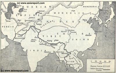
MapHistory - Schematic Asia - Russia China Britain Great Game 1900 AD
A Schematic Map of Historical East Asia at around the year 1900 AD and the turn into the 20Th Century.
Although the Manchu ruled Qing Dynasty Empire had previously conquered large parts of East Asia, including much of Korea, parts of current day Siberia, most of Mongolia, East Turkestan, Kyrgyz, Kazakhs and other tribal lands while subjecting Tibet to a subjugary role nominally ruled for its taxes but yet remote and inaccessible behind its mountainous walls, at the turn of the 20th Century the outer regions of the Qing Empire have been eroded away, much of the north and west increasingly under Russian control while in the south and along the coast Britons and others had fought their way into the Chinese Realm. Notably, Korea has been annexed by Japan and Tibet is shown as a de facto independent territory. Tibet will be invaded by Britain in 1901 AD and will declare Independence not long there after at the fall of
the Manchu Dynasty and the end of Manchu rule over China but also Mongolia and Manchuria in 1911 AD. Other groups such as Mongolians, Kazakhe and Kyrgyz will likewise attempt to reestablish their National independence after the fall of the Manchu Empire.