The South of Xinjiang AR :
This Geographic Map gives an overview of Xinjiang-Uygur Autonomous Region of North-Western China (PRC). The Map includes border areas of neighboring Nations of India, Pakistan, Afghanistan, Uzbekistan, Kyrgyzstan, Tajikistan and Kazakhstan in the West. The Nation of Russia in The North. The Republic of Mongolia in the North-East. The Chinese Provinces and Territories of Inner-Mongolia (AR) and Gansu Province in the East, and Qinghai Province
JiaYuGuan
Introduction to Xinjiang-Uygur AR of China Overview Map 1A - Geographic Map
Laomangnai
Aksai
Chin
Shimenzi Cliff Paintings
Bezaklik Buddhist (Qianfo) Caves
Site of Ancient Beiting City
Miao'Ergou
Site of Ancient Jingyue State
Site of Ancient Malikewate Town
Kashi/Kashgar International Airport
Hotian Town Airport
Mogao Caves - UNESCO World Cultural Heritage Site
Taxkorgan Wild Animal Reserve
Kashmir
Cease-Fire Line)
Qimantag
Tura
Hohxil Mts.
Kunlun
Bairab
Co
Goza
Co
Subei
Xat
Tarim
Hextolgay
Tieshangou
Devils City
Tekes
Gongliu
Nika
Yuergou
Balguntai
Narat
Yining (Xinjiang AR)
Mazhong
   Shan
        Mts
Baishitou
Nanwan Ancient Tombs
Barkol
Yiwu
Qincheng
Archeological Site of Ancient Dahe City
Nom
Dahe
Mingshu
Jingquan
Santaghu
Sangequan
Laoyemiao
Lutoshitou
Bulgun
Terekti
Hanas
Altay
Otgon Tenger Uul (Height 3906 Meters)
Altai
    Mountains
Miao'Ergou
Yumen
Toli
Lisu
Jimsar
Qitai
Shawan Hot Springs
Shawan
Bohu
Hejing
Bulgan
River
Koktokai
Ertai
Fuyun
Urho
Hutubi
Jiangjunmiao
Bulgan
Ulastai
Toksun
Hoxud
Oz Sassyk
Koll
Ozma
Koll
Chirgis
Nur
Dorgon
Nuur
Har Us
Nuur
Hutubi
Bohu
Xayar
Chatyrtash
Ribachi'ye
Ananyevo
Clihik
Karakol
Kogart
Wensu
Kalpin
Muji
Sanchakou
Sanchakou
Pixa
Simawat
Qakar
Nur
Andirlangang
Koxlax
Pulu
Karasay
Yeyik
Muz Tag Shan (6638 Mtrs)
Pulu
Bax Bulak
Waxxar
Miran
Baxkorgan
Koramlik
Karakoram Shankou (Pass)
Kheryia Pass
Tielongtan
Kongchakou
Tianchakou
Chalukou
Kangxiwar
Dahongliutan
Sary Tash
Osh
Jalalabad
Zepu
Kokyar
Akmeqit
Mazar
Stone City
Muji
Ulugqat
Turugart
Wuqia
Yopurga
Bachu
Kashgar
Sost
Gilgit
Yumenzhen
Qaragandy
Zaysan
Bakhty
Tacheng
Bu'Erjin
Kaba
Jimunai
Altai
Hoboksar
Bo'le
Oskemen
Semei
Ekibastuz
Balchash
Ayagoz
Lepsi
Taraz
Shu
Qapshaghai
Zharkent
Korgas
Yining
Qapaqal
Kizil
Wenquan
Baicheng
Changji
Shihezi
Singim
Kumkuduk
Hadiljk
Aqqan
Pamir
Taxkurgan
Karakul
Pirali
Lop
Qira
Markit
Artush
Akqi
Wushi
Awat
Guma
Karghilik
Dachaidan
Qarhan
Buodongguan
Tongtian
Yumen
Liuyuan
Xingxingxia
Mori
Kuytun
Qarqi
Luntai
Qedir
Hayanbulak
Hadadun
Site of ancient Cherchen (Qiemo)
Hongliuquan
Dongluk
Miran - Lost City Archeological Site
Tatrang
Aktaz
Aralqi
Tarim Erchang
Yuli
Jinghe'
Korla Town Airport
Korla
Kuqa
Niya Ruins Site
Keriya
Yadan
Land
-forms
Dunhuang
Yumen (Jade Gate) Pass - Great Wall of China o/t Han & Tang Dynasty
Charklik
Yarkand
Cherchen
Qinghe'
Huiwang Tomb
Hami
Anxi
Alamaty
Karamai
Qoltag
      Mts.
Aydingkol
Turpan
Site of Ancient Gaochang City
Urumqi
Chowd Altai
    Mountains
Chawtag Uul (Peak) (Height 2918 Meters)
Manas
Lake
Ulungur Lake
Tian Shan Mountains
Dongluk Village
Bursan Budai
   Shan
Ancient Qiaowan Fortress Ruins + Great Wall of China
Bogda Shan (Height 4388 Meters)
Karlik Shan (Height 4925 Meters)
Lop Nor
(780 Mtrs)
Yan Guan (Sun Gate Pass) - Beacon Tower o/t Great Wall of China (Han & Tang Dynasty)
Aksai
Aksai (Gansu Province)
JingTie Shan (5206 meters)
Qiaowan
Overhanging/Suspended Great Wall of China
Aksu
River
Maykapchigay Pass - Border China-Kazachstan
Qapaqal
Mayankapchigay (Kazachstan)
Ulungur River
Xazgat
Bhakty Pass - Border China-Kazachstan
Bakhty (Kazachstan)
Korgas Pass - Border China-Kazachstan
Kizil - Buddhist Caves
Mustagh Peak (Height 7546 Meters)
Mustagh Pass (Height 5422 Meters) - Border China-India
Kara-
koram
Mountains
Lop
Karakul
Pirali
Shule
River
Nanga Parbat (Height 8125 Meters)
Bosten
Lake
xxxx
Kashgar
River
Dunhuang Town Airport
Bayin'gholin Mongol Autonomous Prefecture
Urumqi International Airport
Altay City Airport
Go to www.drben.net webring
ChinaReport.com at
To Main Menu of All Websites at DrBen.Net
The China Report
Xiao WuTaiShan (2870 Meters) + Monasteries
Marks location of Monument/ Cultural Historic Site
Marks Airport/Airfield
Beijing "Capital" - International Airport
Beijing City
Marks City, Town or Village (Size)
Xiao WuTaiShan (2870 Meters) + Monasteries
Marks Mountain and Height in Meters
Republic of Mongolia
Kyrgyzstan
Russia
Urumqi - Capital of Xinjiang-Uygur Autonomous Region
Kashgar (Kashi') - City Prefecture
Dunhuang (Gansu Province)
Gansu
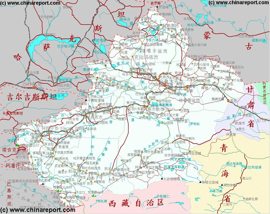
Browse the Map of Xinjiang-Uygur Autonomous Region and Click through to More Backgrounds & Fotos of Places Reported on by www.ChinaReport.com
The North of Xinjiang AR :
The East of Xinjiang AR :
The Eastern Half of Xinjiang-Uygur AR is taken as all Territories west of the Bogda Shan Mountain Range. This region is mainly noted for its historic Monuments and landscapes such as the Yadan Landforms on the Gansu-Xinjiang Border, Famous Lop Nor and the Great Wall of China remnants extending out of Yumen (Jade Gate) through the Taklamakan Desert territories towards Lop Nur (now a dried out salt lake). Nearby the dry Lop Nor are the Lost City archelogical sites of Loulan (KuLoulan) and Miran (near Charklik (Ruochiang).
The East of Xinjiang AR is also the location of the large Ethnic Minority enclave of Bayin Gholin Mongol Autonomous Prefecture, the home of a large concentration of Ethnic Mongolians in China.
The Most well-known Cities and Towns in West Xinjiang AR are Hami also known as Kumul and the Oasis of Turpan near Ayding Lake (=Gol) and located south and beneath the Bogda Shan Range. Especially Turpan is a famous Oasis town popular with Tourists due to its History as an important settlement on the Silk Road. However, at Hami (Kumul) located along the Northern trajectory of the Chinese Silk Road departing out of Dunhuang (just across the border in Gansu Province), was an crossing point where a small Northern Branch of the Silk Road trajectory split off, heading north along the Bogda Shan Range through Oasis in the South of the Dzungar Depression to destinations in current day Kazachstan and beyond.
Mountains
Qong Mustag Shan (6920 Mtrs)
The West of Xinjiang AR :
At the very center of the Southern Half of Xinjiang-Uygur AR lies the wild Taklamakan Desert along which edges travel the Tarim River in the North and a string of Oasis and Gletsjer-fed rivers in the South. These were the pathways of the Northern and Southern Routes of the ancient Silk Road in this vast area. The main feature of the Taklamakan Desert itself are its ever shifting sands and high sand dunes combined with an extremely arid climate.
The Edges of the Taklamakan Desert however sustained a number of important Civilizations in history and  are famous for their lost Oasis Cities, once mighty independant Kingdoms on the pathway of the Silk Road. First and foremost among these is the Lost City of Loulan (rediscovered by Svedish Explorer Sven Hedin), on the West-side of former Lop Nur and at the End of the Konqi River where it used to flow into the Lake. Nearby to the South-West lies another lost Oasis and archeoligical site, the City of Miran.
Follow the rivers along both rims of eliptically the Taklamakan Desert to discover more ancient Towns and (small) Cities. In the South historically the most of famous of these are Charklik (Ruochiang), Cherchen (or Qiemo), Niya or Minfeng Town, Yutian or Keriya, Hotan (Hetian), Yecheng (Kargilik) and Yarkand (or Yarkent). In the North they are Hami (Kumul), Turpan Oasis, Korla (or Kuerle), Tumtux and finally in the far west the City of Kashgar.
Recently a cross-desert highway was constructed to cut through the center of the Taklamakan Desert Area from Niya (Minfeng) Town in the South to Luntai Town in the North.
Tibet AR
Qinghai
Konqi River
Tajikistan
Pakistan
Afghanistan
Lake Balkash
Liuyuan (Gansu Province)
Qilian Shan (Height 5564 Meters)
Jiayuguan (Gansu Province)
Hami (Kumul)
Korla (Kuerle)
Yuli / Lop Nor - County Capital
Peak of God (Height 5445 Meters)
Changji
Cherchen River
Luntai
Loulan - Lost City Archeological Site
Charklik (Ruochiang) - County Capital, Bayin Gholin Mongol Autonomous Prefecture.
HongliuQuan (Qinghai Province)
Kongur Mountain (Height 7719 Meters)
India
Hadadun
Kuqa (Kuche or Kuchar)
Arvat
Wushi
Akqi
Artush (also:Artux) - Capital Kizilsu Kyrgyz Autonomous Prefecture
Torugart Pass - Border China-Kyrgyzstan
Uzbekistan
Irkeshtam Pass - Border China-Kyrgyzstan
Mount Qogir = K2 (Height 8611 Meters)
Khunjerab (or Karakoram) Pass (Height 4800 Meters) - Border China-India
Sost (Kashmir, India)
Yengisar
Shule
Yarkand (Shache')
Tashkurgan (Tajik Autonomous County)
Lake Issik-Kul
Bishkek - Capital of Kyrgyzstan
Lake Kanas
Friendship Peak - Pik Natramdal - You-i-Feng (Height 4374 Meters)
XXX, XXX, Russian Federation
Altyn-Tagh
Mountains
Keriya River
Hotan River
Yarkand River
Markit
Karghilik (Yecheng)
Qira
Keriya (Yutian)
Niya (Minfeng), Khotan Prefecture.
Guma (Pishan)
Tian Shan Mountains
Kazachstan
Almaty - Capital of Kazachstan
Baicheng
Kizil Village
Bayanbulak
Yining, Capital of Ili-Kazakh Autonomous Prefecture
Korgas Village
Zharkent (Kazachstan)
Sayram Lake
Bo'le'
Wenquan Village
Ala Shankou (=Pass) - Border China-Kazachstan
Jinghe'
Karamai (Kelamayi')
Tacheng
Hoboksar
Jimunai
Zaysan (Kazachstan)
Ertix
River
Bu'Erjin
Altai
Kaba Village
Qinghe'
Jungar
(Dzungarian)
Basin
Shihezi
Kuytun
Zhaosu Village
Mori' Kazakh Autonomous County
Golmud (Qinghai Province)
Cherchen (Qiemo), Bayin Gholin Mongol Autonomous Prefecture.
Gilgit (Kashmir, India)
Hami
Basin
Gobi Desert
Dabsa Hu Lake
and Tibet Autonomous Region in the South.
Anxi, Gansu Province
Yumenzhen
Inner-Mongolia
AR
North Xinjiang-Uygur AR is defined here as the parts of Xinjiang Autonomous Region North of the Tianshan Mountain Range, Bosten Lake, the Kurukar Tag Mountains and the City of Korla (Kuerle). The North of Xinjiang then includes the Capital of Urumqi. the Cities of Changji (Capital of Changji Hui Autonomous Prefecture), Shihezi (Capital of Bayin Golin Mongol Autonomous Prefecture) , Karamai (Kelamayi') and Yining (also known as Kulja, the Capital of Ili-Kazakh Kirghiz Autonomous Prefecture). The North of Xinjiang consists for a large part of the Dzunggar Depression High Plains along the southern edge of which lie another series of Oasis fed by melting water from the glaciers atop the Bodgda Shan Range. Both to the West and the North the Dzunggar Depression is delineated by more high mountains. These Mountain Ranges are enriched with some impressive Lakes with abundant wildlife. Through the High Mountains in the West lead number of passes into the neighboring Nations of Russia and Kazachstan.
In the extreme North lies the Friendship Peak of 4374 Meters, whereas in the West the North Xinjiang is bordered by the Altai High Mountains on the other side of which lies the Republic of Mongolia.
The Most Rugged and Wild Part of Xinjiang lies in the West. At the Center of Life in this Region lies Kashgar City, surrounded by a number of desert Oasis Cities such as Yarkant (Shache') and Karghilik (Yecheng). Historically Kashgar re-unites the trajectories of the North- and South-Route of the Silk Road around the Taklamakan Desert. From Kashgar the Silk Road continues Westward through the Iron Gate (Irkeshtam Pass) of the Pamir Mountains into Kyrgyzstan. The Iron Gate and the Pass beyond were in Chinese Hands during most of the Tang Dynasty (618 AD - 907 AD). From the Area near Kashgar the Irkeshtam Pass and Torugart Pass lead into Kyrgyzstan. The path Southward leads through the Ethnic Minority Area's of both the Kirghiz and Tajik to the Khunjerab Pass and along the Karakoram Highway into Pakistan and on to Islamabad.
Further to the South-East of Kashgar lie the Karakoram Pass and the Mustagh Pass leading into the Indian-Pakistan disputed Territory of (Jamu &) Kashmir.
Shule River
Dang
   River
Da Qaidam Hu
Dachaidan (or Da Qaidam) (Qinghai Province)
Shule River
Shazaoyuan (Gansu Province)
Bai Shan - White Mountain (Height 2013 Meters)
Kumkuduk (Xinjiang AR)
Xingxingxia (Xinjiang AR)
Bogda-Shan Mts.
Barkol Tagh Mt. (Height 4266 Meters)
Singim (aslo:Shanshan)
Shisanjianfang
Kurukar tag
      Mts.
Qol Tag (Height 1142 Meters)
Qarqi
Qedir
Yumen
Qarhan (or Da Qaidam) (Qinghai Province)
Hoh Sai Hu (4572 Mtrs)
?? Shan (6300 Mtrs)
Buodong Guan (Qinghai Province)
Qumar Heiyan
Qumar
   River
Yagradagze Shan (Height 5542 Meters)
Tongtian Heiyan
Moron
  Us
Jurhen Ul Mts.
Ulan Ul Hu
Dogai Goring (Lake)
(4814 Mtrs)
Ayakkum Hu
Bukubaidan Shan (Buka Daban) (6860 Mtrs)
Gas
Hu
Kanbujmal (Xinjiang AR)
Tarim Erchang
Aralqi
Aktaz
Tatrang
Hadiljk
Aqqan
Muztag Shan (7723 Mtrs)
Agtag Shan (676 Mtrs)
Akkikki
Gol
The Xinjiang-Uygur Autonomous Region encloses a huge land surface area which, for practicalities, can best be divided into 3 or 4 parts: The North, The East, The Central South taken up mainly by the extends of the Taklamakan Desert, and last - the Extreme West which has the City of Kashgar and various Towns, Rivers, Tashkurgan Tajik Autonomous County (of the Tajik Ethnic Minority) and a variety of high mountain passes into neighboring Nations. Among these, the highest passes in the World, the Karakoram Pass and the Mustagh Pass.
Balchash (Kazachstan)
China Report - Maps o/t Taklamakan Desert & Tarim River Basin
2 Satellite Image Maps of the entire Taklamakan Desert and the Tarim River Basin in Xinjiang-Autonomous Region of Western China. Maps give explanation and backgrounds to Local Geography, the Flow of the Tarim River from the Pamir Mountains in the West to Lop Nur (Dry) in the East, ancient Oasis Cities of the Tarim Basin and Taklamakan Desert, the North and South Routes of the Silk Road in this Area, Past and Current Climate and Historic Backgrounds.
Atas Bogd (=Peak) (Height 2695 Meters)
Adsh Bogd (=Peak) (Height 3802 Meters)
Bajtag Bogd (=Peak) (Height 3479 Meters)
Monchchajrchan Peak (Height 4362 Meters)
Aksu
Aksu
Bishkek
Qapshaghay (Kazachstan)
Lepsy (Kazachstan)
ile
River
Shu (Kazachstan)
Taraz (Kazachstan)
Ayagoz (Kazachstan)
Zaysang
Koll
Oskemen (Kazachstan)
Semei (Semipalatinsk) (Kazachstan)
Ekibastuz (Kazachstan)
Qaragandy (=Karaganda) (Kazachstan)
Golmud
Emin
Emin
Taklamakan Desert
Hetian
Niya
Click Map to go to Full Version !
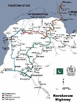
Asia Report - Map of Karakoram Highway / China-Pakistan Mountain Highway
The Karakoram Highway is the highest paved road in the world. It leads from Kashgar down South around the Muztagh Ata Peak to Tashkhurgan Tajik Autonomous County. Taxkurghan lies well South of Kashgar at the base of the Pamir Mountains is the home of the Tajik Ethnic Minority of China as well as large section of the Kirghiz People of China. From Tashkurgan the KKH, as the Karakoram Highway is known among its fans, leads upward to the Khunjerab Pass and River Valley, from where it continues along a spectacular trail into Pakistan's North-Western Frontier Province.
Kanbujmal
Shisanjiangfan
Qumar
Yengisar
Zhaosu
Shule
Mountains
Muji
Murgab (Tajikistan)
Wuqia
Ulugqat
Turugart
Jiashi
Jiashi
Yopurga
Bachu
Mazar
Akmeqit
Kokyar
Zepu (Also:Poskam)
Kangxiwar
Dahongliutan
Chalukou
Tianchakou
Tielongtan
Kongchakou
Sary Tash
Gul'cha
Osh (Kyrgyzstan)
Jalalabad (Kyrgyzstan)
Gulcha
Luobuzhuang
Miran
Baxkorgan
Xorkol
(6163 Mtrs)
Bax Bulak
Waxxar
Jangalsai
Koramlik
Xorkol
Jangalsai
Xortang
Yeyik
Karasay
Andirlangang
Andir
Nur
Qakar
Moyu
Hotan (Hetian) - City Prefecture
Simawat
Koxlax
Xortang
Andir
Pixa
Muji
Kalpin
Aqal
Aqal
Bedel Pass - Border China-Kyrgyzstan
Kogart
Chatyrtash (Kyrgyzstan)
Naryn
River
Naryn (Kyrgyzstan)
Karakol (Kyrgyzstan)
Naryn
Rybachi'Ye (Kyrgyzstan)
Anan'Yevo (Kyrgyzstan)
Clihik (Kyrgyzstan)
Wensu
Xinhe (Kuche or Kuchar)
Xayar
Xinhe
Hoxud
Hejing - County Capital
Yanchi
Toksun & County
Ulastai (Xinjiang AR)
Jangjunmiao (Xinjiang AR)
Qitai (Xinjiang AR)
Jimsar (Xinjiang AR)
Lisu (Xinjiang AR)
Miao'Ergou (Xinjiang AR)
Toli
Yumin
Hextolgay
Xazgat
Urho
Tieshanggou
Terekti (Xinjiang AR)
Ertai (Xinjiang AR)
Bulgun, Russian Federation
Fuyun
Koktokai (Xinjiang AR)
Songshan Hot Spring
Khovd, also: Hovd, Capital of Khovd Aimag, Republic of Mongolia.
Fuhai
Fuhai
Shawan (Xinjiang AR)
Hovd
Olgii (Ulegei), Capital of Bayan-Olgii Aimag, Republic of Mongolia.
Altai, Capital of Govi-Altay Aimag, Republic of Mongolia.
Ulugei
Hanas (Xinjiang AR)
Bulgun (Xinjiang AR)
Sangequan (Xinjiang AR)
Laoyemiao (Xinjiang AR)
Lutoshitou (Xinjiang AR)
Santanghu (Xinjiang AR)
Dahe (Xinjiang AR)
Barkol Kazakh Autonomous County
Yiwu (+County)
Nom (Xinjiang AR)
Qincheng (Xinjiang AR)
Mingshu (Gansu Province)
Baishitou (Xinjiang AR)
Xingxingxia (Gansu Province)
Dananhu (Gansu Province)
Yuergou (Xinjiang AR)
Balguntai (Xinjiang AR)
Xinyuan
Narat (Xinjiang AR)
Gongliu
Nilka
Tekes
Xinyuan
HanTengRi Feng (Height 6995 Meters)
Xat
Tarim
Piqan
Karajul
Subei Mongol Autonomous Township (Gansu Province)
Kunlun Mountains
Qimantag
Tura
Indus River
Sanyu Preceipice Stone Paintings
Site of Ancient Qiaohe City
Turpan
Changji Huizhu - Changji Hui Autonomous Prefecture
16 Daoban (Qinghai Province)
Huanggualiang (Qinghai Province)
Laomangnai (Qinghai Province)
Huatugou (Qinghai Province)
Dingzikou (Qinghai Province)
Dingzikou
Iqe (Qinghai Province)
Sumdo
Nyingxi
Xinjiang Sources
Xinjiang AR
Urumqi
Urumqi Home
Urumqi Hotels
Xinjiang AR Home
Kashgar (Kashi)
Kashgar Home
China Offline Sources
AsiaReport.com Home
China Report Home
China Online Sources
China Online Store
China Maps
China
China Photo Galleries
China Report Club
Tashkurgan Tajik A.C.
Hotan
Hotan Home
Be a 7Search.com Advertiser!
Turpan
Hami Home
Karamay
Karamay Home
Aksu
Aksu Home
Altay
Altay Home
Autonom. Pref.
Bayin-Gholin - Shihezi
Changji (Hui) & Changji
Ili-Kazakh - Yining Home
Kizilsu Kyrgyz - Artux
Turpan Home
Hami (Kumul)
Xinjiang Economy
Xinjiang History
Xinjiang Monuments
Xinjiang Maps
Xinjiang Minorities
Xinjiang Transport
Xinjiang Wildlife
Satellite Maps
Historic Maps

AsiaReport.com - Mastermap of Asia (entire). weergeven op een grotere kaart
Full Geographic  Map of Xinjiang
Xinjiang Autonomous Region Geographic Map 1A
A Geographic overview Map of the entire Xinjiang-Uygur Autonomous Region and large parts of neighboring Nations of India, Pakistan, Afghanistan, Tajikistan, Kyrgyzstan and Kazakhstan, The Republic of Mongolia, as well as bordering Chinese Provinces and Territories of Inner-Mongolia AR, Gansu Province, Qinghai Province and Tibet Autonomous Region. This Map Includes Cities and Towns (shown by size), Main Monuments & landmarks of Xinjiang AR, the Taklamakan Desert in South-Central Xinjiang AR, major highways, provincial railroads, a variety of border passes in the Karakoram Mountain Range and the Tian Shan Mt. Range, plus main mountains, waterways, rivers and lakes of this large region.
Full geographic Map of Xinjiang-Uygur Autonomous Region, China !
Jingquan (Xinjiang AR)