Agr.
Exh.
Ctr.
Go to Full Maps of DongCheng District
This page was last updated on: June 6, 2017
This Map depicts the Central NorthernPart of the ChaoYang District of Beijing , including the YongHegong Lama Temple and Sanlitun North Embassy Area and the 1st part of the Capital Airport Expressway. 
East
West
Best Overview of ChaoYang
Vibes Dancing
Factory 798 and DAD Complex Report
Lama Temple
Ditan Park
Sanlitun Bar Area
Go to www.drben.net webring
ChinaReport.com at
To Main Menu of All Websites at DrBen.Net
Confucius
Temple
Go to Full Maps of South Chaoyang CBD
A Geographic Map of North ChaoYang District (2010)
Click Map to go to Full Version !!
Click to View Geographic Map ChaoYang North-West !
A Geographic Map of North-East ChaoYang District (2007)
This Map shows the North-East Half of ChaoYang District focusing on the Main Landmarks and the most developed parts of the rapidly transforming ChaoYang District in the West. Borders are in the West (Left) The 3rd Ring Road, in the South the Main Railway Line leading East out of Beijing Main Railway Station south and below JianguoMen Outer (Nei) Street (Dajie'). Find Silk Alley, the Place, various Embassies and More on the Map !
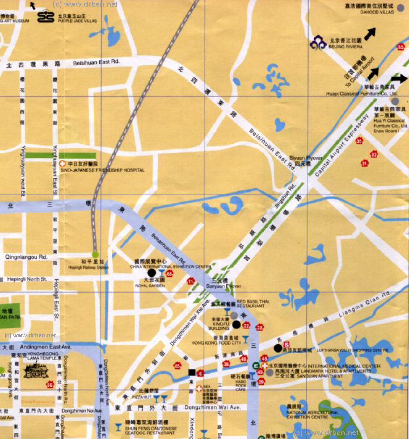
Map of North ChaoYang District focusing on the 2008 Olympic Green (or Olympic Park) in the North section of ChaoYang District. Included in the map are large parts of Haidian District in the West (Left), a small part of Changping District in the North, and minor parts of Dongcheng District and Xicheng District in the South.Browse the Map and follow the Links to more information.
Agricultural
Exhibition Ctr.
Liangma
Qiao
Sanyuan
Qiao
Guangxi
Men
Yuan Dynasty Dadu City Walls Park
Explore this Area in more Detail ..
Olympic
Park
Yonghe
Gong
Sun
Park
Chaoyang Park
Beijing Landmarks
Beijing Introduction
Beijing Online Sources
Beijing
Beijing Home
Beijing Hotels
Beijing Maps - Index
Beijing Public Transport
City Province Transport
Beijing by District(s)
Chongwen
ChaoYang
Dongcheng
Fengtai
Haidian
XiCheng
Xuanwu
6 Outer Suburbs
TiananMen Square
Alphabetical Order
By Function(s)
Forbidden City
Hebei Province
Hebei Province Home
China Offline Sources
AsiaReport.com Home
China Report Home
China Online Sources
China Online Store
China Maps
China
China Photo Galleries
China Report Club
4 Rural Districts
Shijingshan
Maps of Chaoyang
Maps of Chongwen
Maps of Dongcheng
Maps of Fengtai
Maps of Xicheng
Maps of Xuanwu
Maps of Haidian
Maps of Shijingshan
Beijing Great Wall Maps
Beijing North China Maps
Historic Maps of Beijing
BJ Public Transport Maps