In the East, the Shuidonggou Sections of the Great Wall of China connect to the Yanchi Great Wall Sections(Wuzhong Prefecture). In the West they end at the Yellow River (Huang He) at the village of Henghcheng. Hengcheng, as is described in more details below, is a historic location for several reasons. Among things, it used to serve as an important port along the Yellow River, that is before the river was dammed and its waters subsequently dwindled.
(3) Shuidong Gou (水洞沟) Water Cave Gully Great Wall - Directions
This page was last updated: July 21, 2017
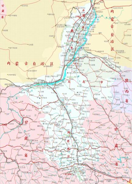
Great Wall of China in Ningxia Hui AR
ChinaReport.comat
China Report - Map of the Great Wall during the Ming Dynasty
Satellite image of China and North-East Asia, with a super-imposed schematic Map of the location and Path of the Great Wall as constructed during the Reign of the Ming Dynasty. Included for reference are City names, geographical features of landscape, Names and locations of Passes on the Great Wall of China.
A Full Google Earth Supported Map Overview of All Structures of the Great Wall of China from East to West, by DrBen.Net (c) ChinaReport.com and Google.com.
My Great Web page
1ST WATCHTOWER ON THE EAST BANK O/T YELLOW RIVER:
The first part of the Shuidonggou that can be reached from the city center of Yinchuan, where tourists usually stay, is the first unrestored watchtower of the Great Wall of China overlooking the Yellow River. This watchtower is situated at the formerly port town of Hengcheng, previously a nothing type of town, which lies about 15 kilometers due west of the outermost ring road of the city of Yinchuan.
Although the western end (or beginning) of the Shuidonggou Wall can easily be found by following the G20 express way from Yinchuan to the Yellow River bridge crossing to the Eastern Bank, from whcih bridge the watchtower can be seen in the distance, in practice bridge the last gap to reach the watchtower turns out to be not as easy as expected.
First directions are hereby given, leave Yinchuan City Center and make your way down to the south-east corner of the sprawling city near the former north gate area. As one will find this is one of the main access points of the city and one of the main transportation hubs, the Northern Bus Station is also situated in this part of town.
Navigate the chaos and follow G211 south-eastward only briefly before entering upon the G20 Highway which leads away in the same south-eastern direction. A bit further on down the G20 Highway meets with G6 Highway, however do not turn off or alter your course.
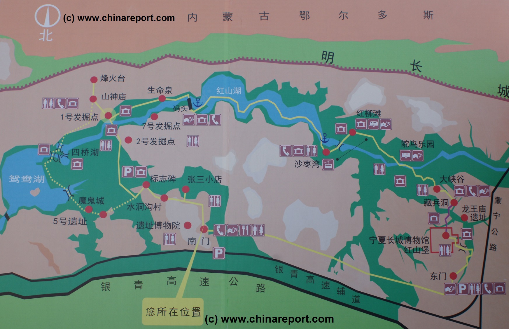
Overview Map of Shuidongou Great Wall between Yinchuan and Yanchi by DrBen.Net.
SHUIDONGGOU OFFICIAL TOURIST SITE:
From the airport exit go north and head up county road (Xian Dao) 102 which lies parallel to the express way. Following county road 102 eastward for some distance one comes to the official visitors point created at Shuidonggou Wall, which extends in both eastern and western directions from this point.
The official Shuidonggou Tourist site is situated at 11 kilometers from Hedong Airport and 19 kilometers from the old city center of Yinchuan.
Having finally left the chaos of the city and traffic one need only follow G20 highway. Marker points along the way are the dwindling reed and marshlands Mingcui Lake (Yinchuan Mingcui Lake Country marsh park) on the northern side of the road, and subsequently the seemingly rather out of place Huanghe Golf Club. It does not look like much but hopefully you will spot the advertisement at its Gate.
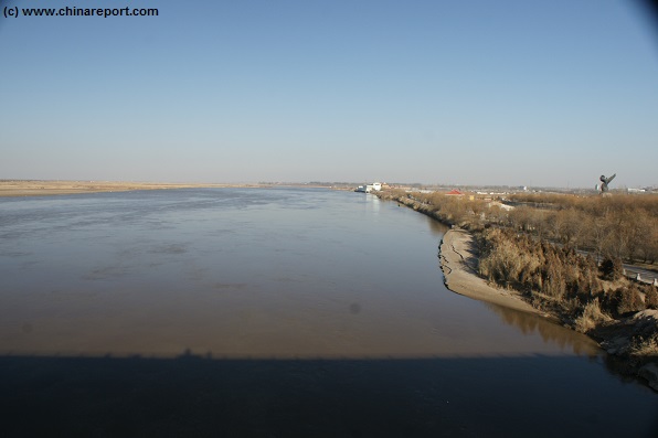
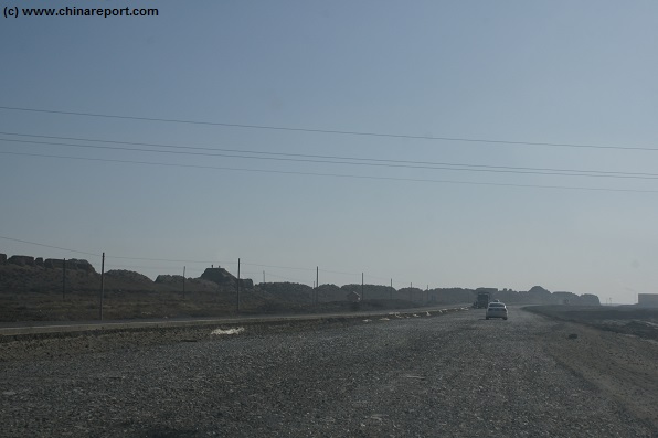
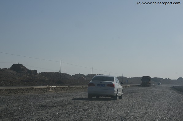
Next, before soon one reaches the Yellow River and the G20 / G211 Road Bridge crossing over to the eastern bank. If at all possible, stop your car to have a first glance of the first Great Wall watchtower on the banks of the Yellow River. The tower, since 2013 surrounded by a newly built holiday park and assorted buildings can be viewed at a distance downstream. It may not have been entirely what one expected. Nevertheless it is a view and a good viewpoint from which to take in an impression of the legendary Yellow River, the mother river of Chinese Civilization which at this point streams by with considerable force. As one may note, the waters of the river, which were still somewhat clear upstream where it passes through the Shapotou Scenic Zone, at this point the Yellow River has taken on its familiar muddy appearance. As the waters are laden with loess dust brought down from Gansu Province and the Ningxia Plain, little or nothing can be seen beyond the surface of the water.
As the 1st watchtower on the west end of the Shuidonggou Great Wall stands a short distance north of the expressway, in order to reach it one has to turn of the expressway at the exit of Yinchuan Airport.
Mind you, one has to turn off southward onto S3/S203/G211, than immediatly turn off and curve back around towards the river and Shicacun / Linhezhen. When succesful, one will find onesself on the S203 County Road heading north along the rivers eastern bank and passing underneat the G20 highway which one drove over. Last
A view from the G211 Provincial Road Bridge of the Yellow River due south-east of Yinchuan. In the distance more to the north and downstream the white building marks the location of the first watchtower of the Great Wall of China on the Yellow River banks. Unfortunately, a recent expansion of the tourist industry has transformed this previously dilapidated town and its ruined wild wall into a fenced off zone and entertainment annex holiday village. Not only is the watchtower no longer visible from the bridge, it is also hard to get to without having been forced to buy a tourist and face a variety of tasteless tourist ″attractions″.
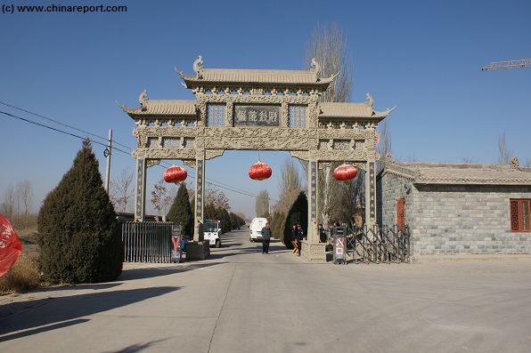
Annoyingly well staffed gate of the Hengcheng Holiday Village and adjoining Changqing Amusement Park. For those looking to explore the Shuidonggou Great Wall by hiking from its first watchtower and the Yellow River eastward meet with disappointment. Since the year 2013 access has been severly restricted. In addition further on eastward a brandnew town annex city suburb has been pounded out of the desert between the wall and the historic road eastward along it.
bits are to follow the road into Hengcheng. Now turned into a holiday village and still under further development in November of 2013, the holiday village is easy to recognize. The Great Wall however is less easy to find than before when it lay at the end of a ruined Hengcheng Village.
Today, the Great Wall is hidden inside the Holiday Park.
Drive up to one of the Gates and see if you can gain access.
WILD WALL OF SHUIDONGGOU:
To find the "un-official" section along the Yellow River at the former Yellow River port of Hengcheng Town, one has to take another shorter but slightly more complicated route. Once, again, follow the expressway eastward out of Yinchuan and cross the Yellow River (Huang He) Bridge. On the other side of the river lies Linhezhen Village due North of the Expressway and Yinchuan Airport at some distance due South of the Expressway.
To get into Linhezhen however, one cannot simply take a northern exit. Instead, take the airport exit of the G20 Qingying Expressway. Turning right and off G20 brings one onto a short stretch of S203 Provincial Road (which leads to 211 toll-road). Pay extra attention here. After only some few hundred meters after exiting the G20 expressway, turn right once more (towards the river) and enter Shibacun Village. The road you are now on passes through Shiba (Cun = smallest size of village) and connects back with a road that is also designated as S203 Provincial Road (Sheng Dao). Turn right onto S203 and follow this road to pass underneath the G20 Expressway that you exited just minutes ago.
After passing this bottle-neck the road to Shuidonggou Great Wall is fairly simply explained. The Wall runs along the north end of Linhezhen Village and adjacent Hengcheng Cun, and it extends for miles and miles eastward.
The shortest route is simply to keep following S203, ignore the turn off (right and East into) Changqing Amusement Park and drive on through HengCheng Village - formerly the Yellow River port serving Yinchuan - for about two more blocks.
The ruined Wall can be found at the north end of this urban sprawl, just beyond a block of newly built luxury holiday villa's and some orchards . Beyond the Wall lie rural lands.
It is possible to Travel to Shuidonggou Great Wall either by Taxi, your own car, or via an organized tour. Technically, one might also take the bus to Yinchuan Hedong Airport and then attempt to walk to Linhezhen village and from there to the Wall, but that would be complicated and wasteful of time and energy. Travel Time by Car or Taxi is slightly more than 30 minutes from Yinchuan Old City Center. Mind you, when taking a Taxi, the driver may take your Shuidonggou for the local Shuidonggou Relic Site (a recenlty discovered paleolithical site which has been built into a substantial tourist venue) and drop you off at its main entrance. In this case, there is no need for panic. Simply walk up the road (North-East of- or to the right of the Paleolithical Site Museum) and find the Great Wall of Shuidonggou passing there. The Wall passes at but a few hundred meters from the Museum.