(2b) Shuidong Gou (水洞沟) Great Wall - History of Shuidonggou
This page was last updated: July 21, 2017
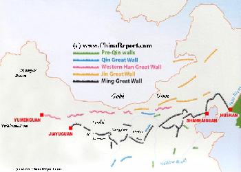
Great Wall of China in Ningxia Hui AR
ChinaReport.comat
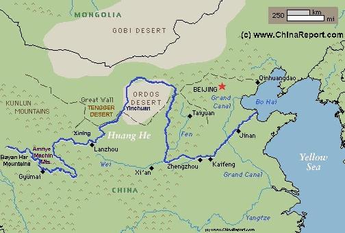
China Report - Map of the Great Wall during the Ming Dynasty
Satellite image of China and North-East Asia, with a super-imposed schematic Map of the location and Path of the Great Wall as constructed during the Reign of the Ming Dynasty. Included for reference are City names, geographical features of landscape, Names and locations of Passes on the Great Wall of China.
Long before the dawn of the Ming Dynasty Era (1368 AD - 1644 AD), the Yellow Plain was already being contested by the nomadic peoples of the north, and the sedentery Han peoples from the south and south-west. The nomads found these regions attractive grazing and hunting grounds, whereas the Han eyed for the same reasons, and as a base for their sedentary lifestyle and agriculture.
Many centurie before the first (official) establishment of the now famous historic Silk Road this situation already existed. In earlier times however, sedentary civilizations were modest in size and through the existence of long distances and many natural barriers a certain seperation existed with each developing more more less freely developing in their own seperate regions. Only in the border regions in between conflicts arose.
As one can find described in more detail in; "Chronology History of the Silk Road", in the earliest recorded times in these wider regions, the traditional enemy was know as the Xiong-Nu. The Xiong-Nu are an early nomadic peoples who′s history remains vague even today. Arising from the steppes of the current day Republic of Mongolia, they managed to build a confederation of tribes which succesfully managed to dominate the lands. Although sources, mainly Chinese records go back only as far as about the year 300 B.C. its is clear that Xiong-Nu roamed the Steppes for several centuries and while expanding their territories southward, eventually came closer and closer into contact with the "Chinese" Civilization. One should however not think of the clearly delineated national borders as people are familiar with in current day times. In the regions between the two Civilizations people and cultures mixed creating their own regional styles and forms.
Today it is known that starting from the beginning of the Warring States Period (475-221 BC), fortifications were built in Ningxia and Inner-Mongolia, to defend Han settler-farmers against the invaders from the north. It is however unclear where exactly these fortifications existed.
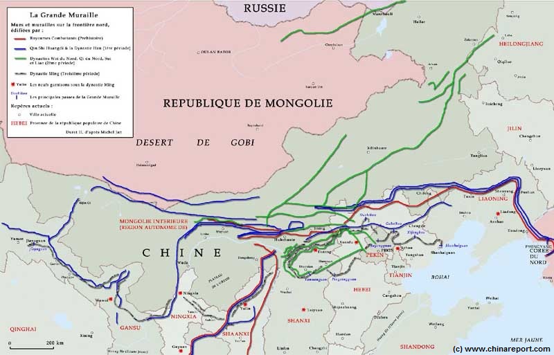
Map Great Wall China - Layers of Dynasties and Era's
A Schematic Map of China and East-Asia, with a super-imposed schematic of the various layers of the Great Wall of China.
Features Pre-Qin Dynasty Wall, Qin Dynasty Wall, Western Han Great Wall of China, the (Northern) Jin Dynasty Great Wall and finally the Ming Dynasty Great Wall as mainly remains today.
Main Features are Names and locations location of Passes on the Great Wall of China, outer layer and inner layer. Includes Shanhai Pass, Huangya Guan (Yellow Cliff) Pass, JiYunGuan Pass, Ningwu Guan Pass, Pingxin Guan, YaMen Guan Pass, Pian Guan Pass, JiaYuGuan pass, YuMen Guan Pass (Jade Gate) and Yang Guan Pass.
Further included for reference are City names, geographical features of landscape and main mountain ranges. Updates occur several times a year adding new pass locations and photo-virtual tours of Passes throughout China.
Source Book
"From Opium War to Liberation"
( no longer available )
Soundbonus - Theme 'Enter the Ordos', from the Game Dune 2000.
A Full Google Earth Supported Map Overview of All Structures of the Great Wall of China from East to West, by DrBen.Net (c) ChinaReport.com and Google.com.
My Great Web page
the brief but crucial Qin Dynasty still survive within Xiji County and Guyuan City of southern Ningxia Hui Autonomous Region today, showing that it was situated mostly to the south, sealing off the mountain passes that lead southward from the Ningxia Plain and the fertile Yellow River into the green valleys of Shaanxi Province. None of the Qin Dynasty Era Wall survives today west of Yinchuan in the area of the Shuidonggou Great Wall. However, due East of the Shuidonggou Wall, Qin Dynasty Era Great Wall remnants can be found due north of Yanchi (actually across the border of Yanchi County (of Wuzhong Prefecture, Ningxia) and within Inner-Mongolia Autonomous Region) proving that a Qin Era (221 B.C. - 207 B.C.) Wall did exist along this line. Archeologist agree that the Qin
Nearby the Great Wall of China is the Shuidonggou pre-historic site.
Apart from a historic site of the Great Wall of China, especially of late, Shuidonggou is also known as an especially interesting paleolithic site, that means an archeological site dating back to an early period of human inhabitation dated somewhere between 2.6 million and 100.000 years ago.
The Shuidonggou Relics Site as it is now widely known, was first discovered in the year 1923 AD by the French palaeontologists Derijin, P. Teilhard de Chardin and one Sang Zhihua (the Inn Holder at Shuidonggou). These esteemed archeologists traveled to Shuidonggou after an earlier find done at the same location in 1919 A.D. by a Belgian Priest (Shouter) had yielded the first paleolithic find in this remote spot, uncovering a man-made stone tool made of quartzite. Upon seeing the item in Europe considerable archeological interest was raised. Hence, some years later a French Team from the Sorbonne University of Paris was dispatched to have a closer look at the scene of the eye-brow raising find.
During their exploits in the desert near their small Inn underneath the Great Wall, the French archeologists came across the evidence of a primitive ancient culture which obviously pre-dated the remains of the Qin, Han and Ming Dynasties. As it turned out, after having excavated the site and finding a large number of stone implements and zoolite, Shui Dong Gou and more specifically the lake bed proved to have been the camp site of early stone age hominids who lived and thrived here many many millenia before. In subsequent excavations more and more sites were uncovered along the ravines. The Cliff Caves found in the ravines around Shuidonggou have since been dubbed Zhenbei Castle, and were identified as a primitive
YOUTUBE VIDEO: Construction of the Great Wall of the Qin, the Han and their armed colonization drives in the West.
Dynasty Wall in Ningxia is characterized not so much by its watchtowers but by its fighting platforms which were between three to ten feet tall, and interspersed along the Great Wall every 219 to 328 yards
For all the work and lives it took to erect, the rammed mud wall constructed in the Qin Era was difficult to maintain. Even during the rule of Emperor Qin some parts already gave way to harsh climatic circumstances. It has since crumpled into virtually nothing. (To be complete: further Qin Dynasty Era Great Wall sections exist far due north of Yinchuan at the foot of Lang Shan Mountains in Bayan Nur League of Inner-Mongolia. This Wall protects the bend of the Yellow River near current day Linhe' and was made of stone. Yet, other sections can be found far due East of there near the City of Hohhot from which they continue Eastward. These are different walls that were in no way continuous with the Qin Wall found between Shuidonggou and Yanchi.)
THE SHUIDONGGOU GREAT WALL DURING THE QING DYNASTY (1644 A.D. - 1911 A.D.) :
Even less is known about the Shuidonggou Great Wall during the Qing Dynasty.
When the Manchu invaded China in the year 1644 A.D., taking the Throne from the Ming, China was included into the Manchu Empire which had already ensured allegiance of the "Mongolian Tribes". Hence, although the Great Wall of China remained to be the official territorial border of China, its formerly hostile borders with the North were suddenly pacified. This rendered the Great Wall in effect almost useless. Thus, it is unknown if any repairs were kept up along the Shuidonggou Great Wall during the Qing Dynasty Era.
What is known is that during the Qing Dynasty Era, a large military fortification was built along the main pass out of Yinchuan, westward into Inner Mongolia. Hence, there must have been some military activity in the regions at that time.
Due to the regional climatic conditions, dry and arid, much of the mud built Great Wall of China in this area survived reasonably intact throughout the Qing Era. In the year 1731 AD an shattering earthquake measuring 8.0 on the Richter scale struck near Yinchuan breeching parts of the Great Wall in the Shuidonggou Great Wall.
Not much more is known about the Great Wall of Shuidonggou in the Qing Era. By the time the first western explorers reached Shuidonggou, it consisted of nothing more than the small lake, the Great Wall and a small Inn ("Zhang San's Inn", a shed with room for 4 or maybe 5) built underneath it. Travelers always passed the Shuidonggou Great Wall when traveling from Yanchi to Yinchuan and vice versa as the main cart trail followed the line of the Great Wall through the desert. No one dared venture into the Mao Us Desert (Ordos) to the north beyond the Great Wall.
SHUIDONGGOU DURING THE WARLORD ERA & CHINESE CIVIL WAR(S) :
In the ending years of the Qing Dynasty and far after that, the Ningxia Hui Autonomous Region and especially the desert regions were among the poorest in the entire Nation. There was no economy to speak of beyond the irrigated and cultivated valley's, and the Inner-Mongolian regions right up to the northern border of Ningxia were still much dominated by nomadic herders and their large flocks of animals. As Dick Wilson describes it in his standard book "The Long March 1935"; the dry and arid regions of Ningxia and North-Shaanxi Province were "Districts unsurpassed in poverty and primitiveness in all of China". The situation was only aggravated by the operations of local gangs of bandits loosely arranged around a former Whampoa Military School Trainee gone Bandit and Warlord. Throughout the 1920's, during the first so-called "United Front" between Kuomintang and the Chinese Communist Party chaos reigned over much of Inner-Mongolia and largee parts of Ningxia. The peasantry lived therefor in fortified farmhouses. No foreigners ever went to these regions except but for a handful of missionaries, a few zealous travelers and some explorers.
In the fall of the year 1923, the Wulsin Mission, financed and supported by the U.S. National Geographic Society passed through the regions, mainly looking for plant and animal species, and recording many photographs of the sights and scenes along the route..
The Misssion past along the west bank of the Yellow River from Inner-Mongolia to Yinchuan (Known as Ningxia Fu at the time), passing through the Gap of the Juicaigou Wall (See: History of Juicaigou Great Wall of China, Dawukou District, Shizuishan Prefecture). Eventhough their reports and many photos left a unique record of their journey, describing vividly the landscapes and difficulties encountered as well as the people met, sadly they did not mention or seem to have encountered the Jiucai Gou Great Wall of China section. Possibly this is due to the fact that even then it was probably badly eroded and short in length. They may have traversed along another pathway.
Upon their return from Xining in East Tibet (Today: Qinghai Province of China (P.R.C.)), passing down the Yellow River by raft from Lanzhou in Gansu back to Baotou in Inner-Mongolia, the mission obviously past along the port of Hengcheng at the Yellow River due east of Yinchuan and therefor the last westernmost) tower of the Shuidonggou Great Wall of China. Again, their records (and the Book: "Vanished Kingdom" a woman explorer in Tibet, China and Mongolia (1921 - 1925); Mable H. Cabbott, Aperture) make no mention of this renowned landmark and national historic monument.
(Under Editing ; perhaps a closer look at the Archives of the National Geographic Society can reveal more).
MAO ZEDONG AND THE NINGXIA GREAT WALL :
As is still frequently quoted to any traveler heading for the Great Wall today, "Chairman" Mao Zedong said "You are not a true man if you haven't arrived at the Great Wall". What far fewer people have heard is that these proud words were stated near the end of the "Long March", in October of 1935, when the rag-tag left-overs of the Communist Armies passed along the Liupan Mountain entering into the south of Ningxia Region. Mao supposedly spoke the words as part of a now famous poem after climbing the steep mountain when finding himself staring down at the ancient winding walls below.
The lines of the Poem written down by Mao at a somewhat later time captures the moment slightly differently, saying:
After passing the Liupan Mountain, the remaining forces of the communist party streamed from Gansu Province via Huanxian (Qingyang Prefecture) into Ningxia along two separate routes and headed along the inner line of the Great Wall to Wuqi (Wuqi County, Yan'An Prefecture) in Shaanxi Province. There they met up with soldiers and representatives of the Shaanxi-Gansu Provincial Party Committee, i.e. the leaders of the only surviving and independent "soviet" within China, the "Shaanxi-Gansu-Ningxia Soviet Area". Therefor, upon their arrival from the "Long March" into the North-Western Regions, Mao Zedong and his troops did not come across the Shuidonggou Wall (, which was part of the main line of the Great Wall of China of the Ming Dynasty). Among the surviving leaders who were there to meet the local Party Committee were Lui Shaoqi, Zhou Enlai, Chang Wentien, a few others and of course Mao Zedong. They brought an army of about 7000 to 8000 surviving soldiers with them. It was an epic moment and the end of the Long March episode.
Overview Map of Shuidongou Great Wall between Yinchuan and Yanchi by DrBen.Net.
THE SHUIDONGGOU GREAT WALL OF THE MING DYNASTY:
As mentioned, the current Shuidonggou Wall was built during the Ming Dynasty Era (1368 A.D. - 1644 A.D.). Although it is known that various western explorers and a number of renowned archeologist visited the site in the early 20th century (1919 and 1923 A.D.), relatively little about history is related in readily available sources. In fact, none of the books ("The Chinese Wall", by Fryer ; "The Great Wall", by John Man ; "Tales of the Great Wall" by Liu Wenyuan ) even mentions Shuidonggou specifically as a pass along the Great Wall. Somewhat more has been written about the Yanchi Great Wall location due to the fact that there both a Sui Era and a Ming Era Wall can be found at some distance from eachother.
SHUIDONGGOU GREAT WALL OF THE HAN DYNASTY (206 B.C. - 220 A.D.) :
After the Qin Dynasty had ended and the Han Dynasty had gained new territories, a new Era of Wall building began, seeing the construction of the now virtually traceless Han Dynasty Great Wall (the most notable sections of which can be found in the far west near Dunhuang, Gansu Povince and are known as Han Chang Cheng). Due to the hard won territorial gains this wall was situated well north of the Ningxia Plain along the Lang Shan Mountains north of the Yellow River in what today is Bayan Nur League of Inner Mongolia (in roughly the same region as the northernmost wall of the Qin Era).
No information could be uncovered about the Shuidonggou location during this period, however it is known that adjacent Yanchi (to the East) was set up as a county for the first time in the early years of the Reign of the Han Dynasty. In addition, it was Emperor Wudi of the Han Dynasty (206 B.C. - 220 A.D.) built Beidiannong City, which was also named Lu City or Yinhan City and became the earliest forerunner of Yinchuan City.
OTHER DYNASTIES:
Subsequent Dynasties built new walls, all of which shall go unmentioned because none of them was built at Shuidonggou. A Sui Dynasty Era Great Wall (589 A.D. – 618 A.D.) segment however can be found in Yanchi County due to the East of Shuidonggou.
Under the Tang Dynasty (618 A.D. - 907 A.D.) Chinese strategy was reversed and mobile warfare brought the armies as far as the shores of the Caspian Sea. While Chinese Armies fought in Xinjiang and further up along the Silk Road in Central Asia, the Great Wall of China was declared redundant, and on Imperial Decree all constructions on the expensive Great Wall were halted.
In the Song Dynasty (960 A.D. - 1279 A.D.), the old city of Yinchuan was destroyed. It was subsequently, rebuilt and renamed Huaiyuan Town of Xing State. Briefly, the new city Huaiyuan became the seat of the Xingqing Prefecture Government of the Song until they were driven out entirely.
While the Chinese States fought eachother for centuries over ultimate supremacy over their Cultural Realm, there was little time and effort to spare for launching invasion of the nomadic planes in search of fresh living space. Thus, the nomads of the plains lived their lives unbothered overtime organizing themselves into a large form of early confederate State, which dominated East and Central Asian territories between Siberia, Mongolia (Inner- and Outer-) and more western regions such as current day Kazakhstan, Kyrgyzstan and current day Gansu Province of the Peoples Republic of China. In the latter case, Xiong-Nu territories bordered directly on the lands claimed by the Qin People of the State of Qin, which for this reason was heavily militarized.
Subsequently - after the unification of China and the creation of a unified Imperial Realm, the Qing could broaden their horizons and turn their attention to new expansions of territory. Thus, as part of a drive to expand the Great Empire, the first organized waves of Han settlers arrived during the rule of the notorious Emperor Qin with attempts to colonize the Yellow River valley in today's Inner-Mongolia Autonomous Region and at locations around Yinchuan in the Ningxia Plain.
The farmers of the Qin Era represented a true colonization drive and attempt to hold on to lands that
"Castle" dating to the Neo-Lithicum (New Stone Age) (The museum says it was inhabited around 30.000 years B.C.). Interestingly, at a later time the military of the Ming Dynasty made further use of the site turning it into a hidden military installation along the Great Wall of China.
After 80 years and 6 seperate archeological digs performed at Shuidonggou, there are a total of 3 archeological sites to visit today.
SHUIDONGGOU AND NINGXIA IN THE WESTERN SUNRISE (XI XIA) PERIOD (1038 A.D. - 1227 A.D.) :
Around 1000 A.D., the Tangut kingdom of Western Xia declared independence from its Central Chinese overlords creating a small Empire that was centered in the Ningxia Plain of the Yellow River.
China Report - Map Yuan Dynasty Mongol Empire in Time 1206 AD - 1294 AD
A Schematic Map of the Mongol Empire of Genghis Khan (TeMuJin) and descendants through its several stages of conquest in its short but Impressive Existance in History. Timeline depicts the Mongol Conquest starting in the Year 1206 AD, when Genghis Khan first united the Mongol-Turkic Tribes of Mongolia and Lake BayKal becoming Great Khan. The Timeline continues through the year 1219 AD, the year 1223 AD taking Transoxiania, 1227 AD, 1237 AD when the Northern Jin Dynasty of China was annihilated, 1259 AD conquering ancient China above the Jiangste River and 1279 AD when all of China was taken and the Yuan Dynasty Established under the Kublai Khan. Last is the Year 1294 AD when the
Often in conflict with the neighboring Chinese Song, Yurchen Liao, and Chinese Jin Dynasties their military was strong enough to retain sovreignty. That is, until the rise of the infamous Mongolian Leader Temujin, also known as Genghis Khan in Mongolia to the North.
In the year 1209 A.D. the Mongolian hordes swept
down from the northern plains for the first time, breaking through what is today known as the "Three Gates Pass" (San Guan Kou) in the Helan Mountains before descending upon the Tangut Capital of Yinchuan. In the process the Tangut were defeated, subdued by the larger Mongolian Empire but the Khan showed mercy and instead of killing the royal family, forced the Tanguts to pay tribute to his superior throne.
Genghis intention was that the Tangut Empire become a province of his Mongolian realm, however in the ensuing period while Genghis Khan himself was out far in the West laying his wrath on the Kwarezmian Empire and taking half of the Middle-East as his possessions, the Tangut rebelled and rose again founding a 2nd Capital within western Inner-Mongolia (at Khara-Koto, today Heicheng, Ejin Banner, Alxa league, Inner Mongolia Autonomous Region).
Mongol Empire reached its largest geographical size and Zenith, 22% of world land area, but through lack of central leadership and over-expansion fragmented into 4 large parts, then imploded upon itself.
Source Book
"I Visit Yenan"
( no longer available )
SHUIDONGGOU GREAT WALL SINCE 1949 :
In the history of the Peoples Republic of China (I.e. Since October 1949 A.D.), the Shuidonggou stone age site was among the first Old Stone Age site to be carefully archeologically examined and documented. Estimates of human inhabitation range from 100.000 years ago to 30 thousand years ago and evidence includes human bone fragments and parietal bones.
In 1988 it was given the national level protected status of "Key Cultural Relic Unit under State Protection " by the State Council, and it is considered a key site in the understanding of early human development in East Asia and the Eurasian Continent entire. It will surprise many to hear that the hominids who lived at Shuidonggou all carried European features and must have migrated overland to this location from somewhere on the other side of the Eurasian continent. There they met people of a different culture and genetic make up.
Over 30.000 Implements and stone tools found resemble those of the Moste and Aurignacian culture found in Europe. The Shuidonggou sites also yielded a spectacular collection of fossilized species, 67 species altogether, including wild donkey, rhinoceros, hyena, antelope, cattle and pigs.
Today, Shuidonggou Site of the Paleolithic Age and Zhenbei Castle of the Neolithic Age are held to have been the earliest residential areas in the Ningxia Plain and Yinchuan City Area (Prefecture).
From the history of Yanchi Great Wall it is known that during the high-point of its existence in the Ming Dynasty Era the, Ningxia Zhen Garrison (i.e. Yinchuan) was responsible for the protection, defense and patrolling of the Yanchi Section. The jurisdiction of the Ningxia Zhen for guarding the Great Wall ran from Yanchi in Eastern Ningxia (Today Yanchi County, Wuzhong Prefecture) to Jingyuan and Gaolan in North-Eastern Gansu Province. Clearly that included the Shuidonggou and its Great Wall.
The Red Fortress at Hongshan (Red Mountain) is a previously
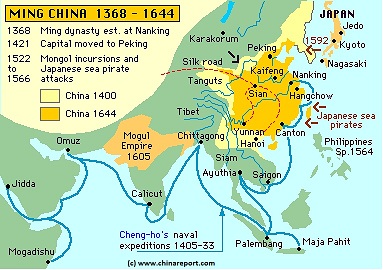
Mini-map showing the re-emergence of China as an independent state during the Ming Dynasty. Clearly visible is the front line of the Great Wall running south of the Ordos Desert (Mao Us), which included Shuidonggou.
undescribed part of the Shuidonggou Great Wall. An ancient site with a history going back to the deep Stone Age, the cliff caves were integrated as part of the Shuidonggou defenses during the Ming Dynasty when they are supposed to have become the first prototype of a cave tunnel hidden military installation in Chinese History. That is, cliffs around the Red Mountain are dotted with man-made caves which already in ancient times constituted a hidden and fortified city with its very own water-well. During the Ming Dynasty the cave system was further perfected leading to the emergence of a hidden fortress behind the Great Wall. Not only could an army hide there and lie in wait to pounce upon an unsuspecting enemy, the cliff-caves provided an excellent defense lethal to any enemy breaking through the Great Wall itself.
It is unclear if it is entirely true that the Cliff-Cave Fortress was the first ever such installation in Chinese history, however the Red Hill Fortress and its hidden cave tunnels do provide a rather unique military construction, not (easily) found elsewhere along the Great Wall of China. That is, apart from the Wall and the Fortress hidden within the loes blown ridges of Hongshan, there is a surpising 965 meters of underground tunnels available all of which can safely be explored today. As has been shown by archeologists, the tunnels were, among things, used for food storage and as an arsenal. There ware 9 rooms among which a kitchen and a large meeting room, with an additional 9th in use as an interior well, providing water even when the fortress was surrounded.
A well thought out entrance system allowed for easy defense and secret sighting of the surrounding lands.
One year after the end of the "Long March", on and just after the 24Th October the Shuidonggou finally saw the passing of Communist Armies on the way from the east along the Great Wall to the banks of the Yellow River and what would become known as the Ningxia Battle (or Campaign). After passing along the Shuidonggou Great Wall, the men and women of the red armies amassed reached the Yellow River port of Hengcheng, on the Eastern Bank just inside the Shuidonggou Great Wall, and under the dead of night started crossing the river. In the first night, headquarters, the 30th corps and the women's regiment were successfully landed on the western shore to take the Battle to Yinchuan and the seat of the Kuomintang aligned Hui Warlords of Ningxia and Gansu (The so called "Ma Clique of Warlords"). Although no tales, histories, relics or otherwise useful information can be found on this controversial episode in Communist Party History at the Ningxia Museum, nor at the Great Wall Museum of Shuidonggou, or elsewhere, likely the Great Wall witnessed some great scenes at the time.
As for the Ningxia Campaign; it seems to have been deliberately sabotaged by Mao Zedong for political reasons, resulting in the massacre of the landed armies. The main battle, which took place on the western shore of the Yellow
River near Yinchuan, was lost within two weeks. The remaining armies were however never called back and some fought their way through Ningxia, past Jinchang & Yongchang in Gansu to their final demise at Gaotai, near Zhangye. An epic, hopeless and unnecessary journey, that left only a few survivors. The political winner of the maneuvering was Mao Zedong, no doubt.
During the Anti-Japanese War period (1937 A.D. - 1945 A.D.), which started in earnest after the arrival of the Communist Forces in the North-West, the Shuidonggou Great Wall and all other parts of the Great Wall of China within the Ningxia Region were part of the territory of the "Shaanxi-Gansu-Ningxia Soviet", which soon found itself administered by Mao Zedong and his close political allies from the towns of Bao'An and later Yan'An in Shaanxi Province. With the Anti-Japanese War and the Civil War going on at the same time, while Mao Zedong and clique installed a crushing dictatorship to rule over the newfound communist colony (and experimented with methods of suppression and brain washing) no outside travelers entered or traversed the regions. The few foreigners remaining in the region, mostly missionaries and Priest, were encouraged to leave and/or otherwise driven out.
Throughout the period a number of foreigners did reach Yan'An and visited the Communist Commune there, however they mostly did so on a political agenda and for their own purposes having little eye for the historical structures found strewn throughout the lands.
Hence no news or information about the Great Wall in Ningxia, and more specifically Shuidonggou is available from this period.
The Path of the Yellow River through Tibet & China :
Schematic Map of the Flow Path of the Yellow River through China.
Click Map to go to FULL Version !
Naturally, the Mongolian Khan could not ignore the situation. And so, after his vengeful conquests of the Kwarezmians, the Great Khan returned to punish his disrespectful subjects.
The final end of the Tangut came in the year 1227 A.D. when the Mongol Armies returned to Yinchuan,
traveling down from Inner-Mongolia along the East Bank of the Yellow River, bypassing the natural barrier of Helan Shan entirely and instead passing along the valley of the Yellow River to attack the city from its eastern flank.
In so doing, the Mongol Armies past through a gap in the natural defenses of the region that has since been closed by the Shuidonggou Great Wall of China.
Crossing the river at Hengcheng, the Mongol Armies then flooded the fortified city by breaking the dams of its famous ancient canal system (dating to the first colonization of the region during the Han Dynasty). The results were devastating, and its is likely that at this time the Tangut Kings Tombs (Xixia Wanling) were destroyed. Whomever was left after that was either killed, or led into captivity and slavery.
In the same year, the 2nd Capital of the Tangut at Khara-Koto suffered a similar brutal fate, although even after its destruction and the massacre of the Tangut Garrison that city remained inhabited (by Mongolians).
Finally overrun by the rising Mongol Empire of Genghis Khan, the Tangut
realm made up of Ningxia and the western Inner-Mongolian regions was absorbed into the Mongolian realm as a Province, leaving it as the ideal springboard for Mongolian Troops to penetrate into the central Han Chinese heartlands following the Qingshui River valley southward. If it were not for his unexpected illness or battle wound, leaving him to die near mount Liupan in southern Ningxia, Genghis (Temujin) would have led the invasion himself.
When some years later, after burying Genghis and choosing a new Leadership, the Mongolians did invade, they conquered all of China creating their Cathay Khanate (a province of the Mongolian Empire) and so making Ningxia part of the larger Chinese realm again.
It was during the Yuan Dynasty Era (1271 A.D. - 1368 A.D.) that Yinchuan and Ningxia saw the emergence of cross-border trade, with caravans traveling from Khanbalik (Beijing) and elsewhere, through Yinchuan and the Sanguan Pass, far into Mongolian and Central Asian territories. It turned out to be a very lucrative trade and toll was levied on each cargo at the Great Wall Gate(s) west of Yinchuan in the Helan Mountains. The tea trade, although interrupted in the Ming Era would continue for centuries making use of the same caravan routes and stop-over points.
It was also during Yuan Dynasty Era, that the regions of Ningxia and neighboring Gansu Province saw a large influx of Islamic Soldiers, former allies of the Mongols in their battles who now came to settle in the fertile regions found south of the Great Wall. Their descendants still live within Ningxia today and are known as the Hui People, who - until fairly recent times - were the dominant ethnic group found within the regions.
Reasserting Chinese authority over the Ningxia Plain would be among the first goals of the Ming Dynasty in their attempts to get rid of the Mongolians and drive them out of China. And when the Ming reached Ningxia they would remember the shattering defeats of the Tangut and how they came about. Adamant that the Mongol Invaders should never return to rule over China again, the Ming set to work planning and building their fortresses and a Great Wall to protect and keep the recaptured Ningxia lands.
6) Shuidonggou - Water Cave Gully and Great Wall ruins
7) Shuidonggou Great Wall - Wild Wall Sections
S) Shuidonggou Great Wall - Online Sources
Map with Schematic Outlines of the various versions of the Great Wall of China built during successive Chinese Dynastic periods. The supposed trajectory of the Great Wall completed in the year 210 BC in the Qin Era is most clearly outlined in blue. As one can make out, this Mud Wall is gathered to have run between Anxi in the Hexi Corridor of Gansu Province in China's far west and to have terminated east of Pyongyang, the current day Capital of North Korea (D.P.R.K.).
previously been out of reach of the due to the fact that the nomadic Xiong-Nu were far to strong militarily. In their defense, military garrisson were established on the plain and armies sent forward, while the colonizable land was shut behind the first ever version of a continious Great Wall of China. This wall, which was completed around the year 218 BC, included much of current day Inner Mongolia Autonomous Region as well as about half of current day Ningxia Hui Autonomous Region into the realm of the Great Qin Emperor. Within decades however, the Empire as well as the mud Great Wall crumpled to the ground leaving only traces in history.
Although the Qin's (221 B.C. - 207 B.C.) initial attempt at colonizing the Ningxia plain failed, in the following period of the Han Dynasty (207 B.C. - 220 A.D.) the colonization succeeded and the first Chinese Farmers raised their crops and filled their granaries there. Unintentionally, this created an even more attractive situation
for the nomads in the North. Where first they descended down to these regions to graze their herds during especially harsh winters, in the same situation they now found Chinese farms in their paths. As a result, the Chinese settlers suffered from continuous raids, especially during and after the harvest season. They needed protection and they needed more than just their own military garrison. As could be glanced from the above, a ready answer was already available in the ancient custom of wall building in China. In fact, several walls had been built on the border by various northern states in an attempt to twart attack.
GREAT WALL OF THE QIN DYNASTY (221 B.C. - 207 B.C.) IN NINGXIA :
In the Year 221 A.D., Qinshihuang unified China and it was at this important time that the Yinchuan area (Today the city of Yinchuan, Capital of Ningxia Hui Autonomous Region) in the Ningxia Plain of the Yellow River was placed under the Beidi Prefecture. As, this was the first ever Han colonization drive and there was no wall yet the settlers lived a dangerous and exposed life on the fringes of their society, left virtually in a no man's land. With the nomads superior in movement on better and taller horses, the Qin Military, although disciplined and previously succesful stood little chance of claiming the land for a prolonged period.
In order to salvage the situation and put an end to fthe highly flexible and mobile warfare of the nomads, the Qin Emperor had little choice but to opt for their exclusion by means of building a wall.
A first wall in the regions south of the Ordos Desert was built during the reign of Qin Shi Huangdi (221 B.C. -207 B.C) partially on the basis of connecting together the walls as they had been built by the northern states. However, as with many of the Qin Emperors projects, the new wall was conceived on a much larger, indeed grandiose scale.
Although it seems hard to imagine such an event occurring today and therefor this way long perceived by historians as a legend, within the span of but a few years the Qin Era Great Wall of China reached a phenomenal length, strecthing from the current day Gansu Province in the west via the regions of the Ningxia Plain all the way to Korean Peninsula in the east. Apart from perhaps the building of the Great Pyramids of Giza in Egypt, this was a truely unprecedented feat requiring an unusual degree of social organization and Government force.
The completion of the Great Wall of China of the Qin Emperor was an enormous human victory that however came at an enormous cost, as is still much remembered today. It is said that for every meter of the Qin Dynasty Wall, one human life was sacrificed. Given its length of an estimated 10 thousand kilometers in total, this made it what is still recognized as probably the largest graveyard in human history. It was a staggering feat, in engineering, architecture, aspiration and also of inhumanity. The terrible costs, combined with those of other equally grandiose projects would eventually lead to rebellion and the fall of the Dynasty. However, before the death of the by then hated Emperor would be completed.