A Listing of maps of China and Inner Mongolia AR, Mongolia as well as relevant subjects such as the (historic) Silk Road, the Great Wall of China, etc.
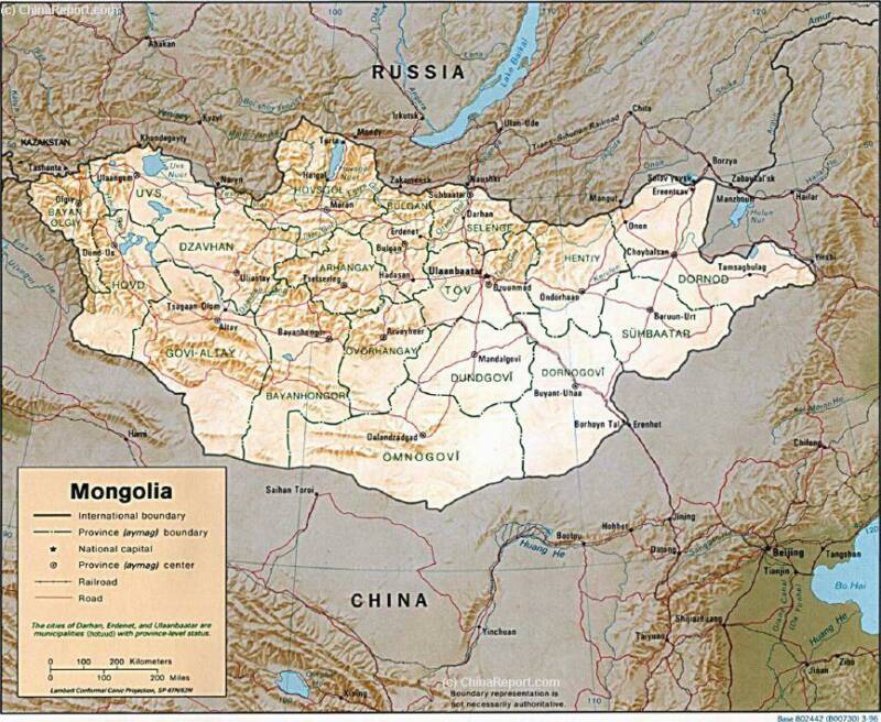
Maps of Mongolia and China (P.R.C.).
Mongolia Report Maps
Republic of Mongolia Maps - Index
AsiaReport.comat
Great Wall of China Path & Locations Map
The Mongolia Maps Index gives acces to all Maps relevant to the Republic of the Mongolia, neighboring regions and Area's of Specific Interest within that Mongolia, as used and/or produced by MongoliaReport.com. Please use these Maps to find your way easily around the Nation, Provinces (Aimag), Cities, Area's and many Monuments & Landmarks.
A Geographic overview Map of Gansu Province entire delineating provincial borders and parts of neighboring Xinjiang-Uygur Autonomous Region Province and Qinghai Province in the West, Inner Mongolia AR and Ningxia Province in the North, Shaanxi Province to the East and Sichuan Province in the South. Includes Cities and Towns (shown by size), Main Monuments & Landmarks of Gansu Province, the flow of the yellow river through Sichuan, Qinghai, Gansu and Ningxia Provinces, BingLing Si, Maji Shan and Mogao Caves UNESCO World Heritage Sites, Main Mountains (with Height), major highways, provincial railroads and main railroad-stations, and main waterways & rivers. This Map further provides links to on site photos and information on the Cities and Main Monuments Other sites will be included in the Future.
Gansu Province Map 2 - Schematic Map
A Schematic overview Map of Gansu Province entire delineating provincial borders and Main Landscape Features in Gansu and parts of neighboring Xinjiang AR and Qinghai Province in the West, Inner Mongolia AR and Ningxia Province in the North, Shaanxi Province to the East and Sichuan Province in the South. Includes Cities and Towns (shown by size), Main Monuments & Landmarks of Gansu Province, the flow of the Yellow River along the borders through Sichuan, Qinghai, Gansu and Ningxia Provinces, BingLing Si, Mogao Caves and Maiji Shan UNESCO World Heritage Sites, Deserts, Mountains (with Height), major highways, provincial railroads and main railroad-stations, and waterways & rivers. This Map further provides links to on site photos and information on the Cities and Monuments.
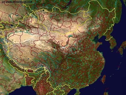
A Satellite image Based Map of China and East-Asia, with a super-imposed schematic Map of the Location and Path of the Great Wall as constructed during the Reign of the Ming Dynasty.
Included for reference are Locations and Names of Passes on the Great Wall of China and their significance. Further Reports link to More Photos and History & Backgrounds of each Great Wall of China Site. Further depicted are City names, geographical features of landscape, rivers and more.
Map China Ethno-Linguistic / Language Distribution China
A Full and complete Map of China (PRC) identifying all Language Areas big and small in all Provinces and Autonomous Regions of China.
Map includes Turkic Languages (Uygur, Kazakh, Kirghiz, Salar & Uzbek), Mongolian Language and Sub-Divisions (Mongol, Tu, Daur and Dongxian), Tungusic Peoples (Oroqen, Evenki and Xibe) and Languages, Korean, Tajik (Tadzhik), Mon-Khmer (Kawa + Puman (or Pulang)), Hui, Uygur (Uighur), Tibeto-Bhurman Languages, Tai and Miao, Yao and She' Language Area's and Borders. Main Area's and sub-divisions of Han Languages (Northern Mandarin, Eastern Mandarin, South-Western Mandarin and Cantonese) further included. This color-coded ethno-linguistic Map (of 1967 AD) identifies at a glance most ethnic minority regions in China.
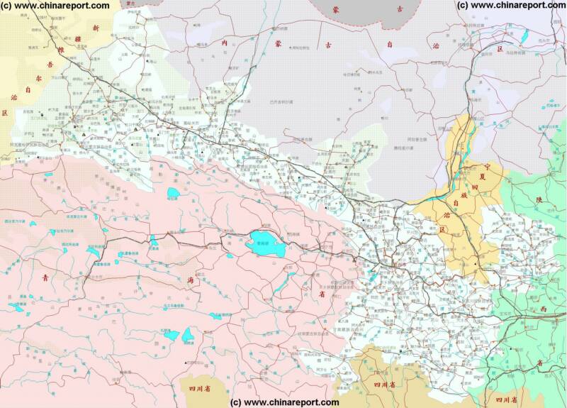
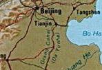
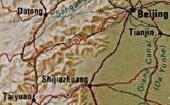
North China - Beijing-Tianjin, Hebei Province, Shanxi Province, Inner Mongolia, Ningxia, Mongolia + wider Area Maps (A & B)
See North China with Beijing and Tianjin Cities, Hebei Province, Shanxi Province, Inner Mongolia Autonomous Region, Ningxia Autonomous Region and the Republic of Mongolia at a glance and navigate the various chinese provinces and regions, capital cities of Mongolian Aimag (Provinces), rivers, lakes, landmarks and locations.
CLICK MAP AND LOCATIONS TO GO TO FULL IMAGE AND AVAILABLE INFORMATION !!
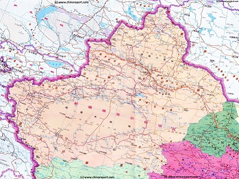
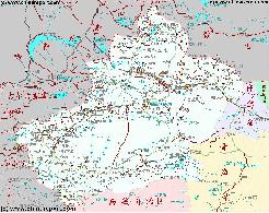
Xinjiang Autonomous Region Geographic Map 1A
A Geographic overview Map of the entire Xinjiang-Uygur Autonomous Region and large parts of neighboring Nations of India, Pakistan, Afghanistan, Tajikistan, Kyrgyzstan and Kazakhstan, The Republic of Mongolia, as well as bordering Chinese Provinces and Territories of Inner-Mongolia AR, Gansu Province, Qinghai Province and Tibet Autonomous Region. This Map Includes Cities and Towns (shown by size), Main Monuments & landmarks of Xinjiang AR, the Taklamakan Desert in South-Central Xinjiang AR, major highways, provincial railroads, a variety of border passes in the Karakoram Mountain Range and the Tian Shan Mt. Range, plus main mountains, waterways, rivers and lakes of this large region.
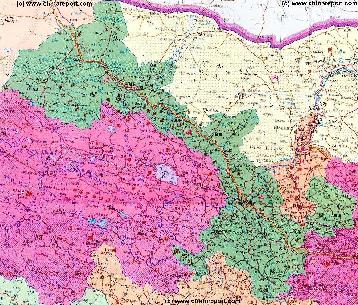
Xinjiang-Uygur Autonomous Region Shematic Map 2A
A Schematic overview Map of Xinjiang-Uygur Autonomous Region entire and large parts of neighboring Nations of India, Pakistan, Afghanistan, Tajikistan, Kyrgyzstan and Kazakhstan, Russia, The Republic of Mongolia, as well as Chinese Provinces and Territories of Inner-Mongolia AR, Gansu Province, Qinghai Province and Tibet Autonomous Region.
This Map Includes Cities and Towns (shown by size), Main Monuments & landmarks of Xinjiang AR, the Taklamakan Desert in South-Central Xinjiang AR, major highways, provincial railroads, a variety of border passes in the Karakoram Mountain Range and the Tian Shan Mt. Range, plus main waterways, rivers and lakes of this large region.
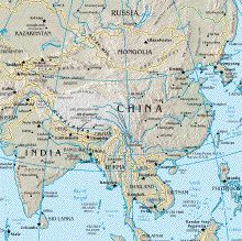
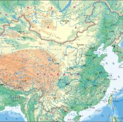
China Report - Map of China and Bordering Nations of Asia
A Geographical overview Map of China and neighboring Nations of Central, East and South-East Asia with National Borders and Capitals. Nations are Bhutan, Nepal, India, parts of Pakistan, parts of Afghanistan, Tajikistan, parts of Uzbekistan, Kyrgystan, parts of Kazakhstan, Eastern parts of Russia, Mongolia, North Korea, South Korea, a small part of Japan, and further the South-East Asian Nations of Vietnam, Laos, Cambodia, Thailand, MyanMar (Bhurma) and Bangladesh.
Map includes names of all Capitals of all 22 Chinese Provinces, Five Autonomous Regions (Inner Mongolia, NingxiaHui,Guangxi Zhuang, Tibet, Xinjiang), Two Special Administrative Regions and Four Muncipalities (Beijing,Chongqing, Shanghai, Tianjin).Main Deserts Gobi and Taklamakan, Mountain ranges, Rivers, Lakes, Sea's and Oceans included.
Map of China and Bordering Nations of Asia - Detailed Topographical View
A Geographical overview Map of China and neighboring Nations of Central, East and South-East Asia with National Borders and Capitals. Nations are Vietnam, Laos, Myanmar (Burma), Bhutan, Sikkim, Nepal, India, parts of Pakistan, parts of Afghanistan, Tajikistan, parts of Kyrgystan, parts of Kazakhstan, Eastern parts of Russia (Russian Federation), Republic of Mongolia, North Korea, South Korea, a small part of Japan, and further the South-East Asian Nations of the Philippines, Vietnam, Laos, Cambodia, MyanMar (Burma) and Bangladesh.
Map includes names of all Capitals of all 22 Chinese Provinces, Five Autonomous Regions (Inner Mongolia, NingxiaHui,Guangxi Zhuang, Tibet, XinjiangUighur), Two Special Administrative Regions (HongKong&Macau)and Four Muncipalities (Beijing, Chongqing,Shanghai, Tianjin).
Main Deserts, Mountain ranges, Mountains&Heights,Rivers, Lakes, Sea's and Oceansaremarkedwiththeirnames.
This page was last updated on: August 26, 2017
My Great Web page
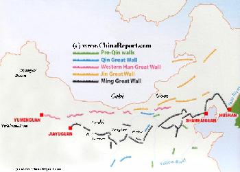
Map of the Great Wall China - Layers of Dynasties and Era's
A Schematic Map of China and East-Asia, with a super-imposed schematic of the various layers of the Great Wall of China.
Features Pre-Qin Dynasty Wall, Qin Dynasty Wall, Western Han Great Wall of China, the (Northern) Jin Dynasty Great Wall and finally the Ming Dynasty Great Wall as mainly remains today.
Main Features are Names and locations location of Passes on the Great Wall of China, outer layer and inner layer. Includes Shanhai Pass, Huangya Guan (Yellow Cliff) Pass, JiYunGuan Pass, Ningwu Guan Pass, Pingxin Guan, YaMen Guan Pass, Pian Guan Pass, JiaYuGuan pass, YuMen Guan Pass (Jade Gate) and Yang Guan Pass.
Further included for reference are City names, geographical features of landscape and main mountain ranges. Updates occur several times a year adding new pass locations and photo-virtual tours of Passes throughout China.
Inner Mongolia Autonomous Region Map 1A - Geographic Map
A Schematic Map overview of North & North-Eastern China's Inner Mongolia Autonomous Region entire, clearly delineating borders and including sections of all bordering Nations as well as bordering Chinese Provinces and Autonomous Regions of China.
Map and description include Main Cities and Towns, Main Monuments & Landmarks of Inner Mongolia AR and adjacent provinces & regions, the locations of the Great Wall of China inside the Map Area, major highways and road connections, provincial railroads and main railroad-stations, and main waterways, rivers and lakes of Inner Mongolia AR and wider region. This Map further provides links to on site photos and information on Cities, Main Monuments & Sights of Inner Mongolia.
Asia Report - Map East Asia - Prefectures and Provinces.
A Satellite Image Map of the better part of East Asia focussing in the Peoples Republic of China and the Republic of Mongolia.
Map depicts all Prefectures within the Peoples Republic of China as well as the Provinces (Aimag) of the Republic of Mongolia. Further included are parts of neighboring nations of Kyrgyzstan, Kazakhstan, Tuva Republic, parts of Siberia and the Russian Federation, both Koreas (North and South), southernmost Japan, Taiwan, Northern Vietnam, Laos, the larger part of Myanmar (Burma), Eastern India (including Sikkim and Aranuchal Pradesh), Bangladesh, Nepal, the Kingdom of Bhutan, Bangladesh and occupied Tibet.
Browse the Map and navigate through to each City Prefecture, Rural Prefecture or Ethnic Minority Autonomous Prefecture within the Peoples Republic of China today. Full names are given where possible. Map further includes location of main cities where convenient for better understanding of Map and Locations.
Mongolia Report - Map of Mongolia & Mongolian Territories
A Satellite Image Map of the Mongolia and all Mongolian Territories within the neighboring Nations of the Peoples Republic of China and Russian Federation. Map overviews Mongolia, Tuva Republic and Siberia in the Russian Federation, large parts of Xinjiang-Uighur Autonomous Region, Inner Mongolia Autonomous Region and Manchuria (North and North-Eastern China) giving a Full Overview of all. Clearly visible details of geographical features such as national borders, provincial divisions, mountain ranges, rivers, valleys and lakes, name and location details of Cities and Villages (clearly visible).
Mouse over Image, click map pins and link through to find more information on any map location or feature.
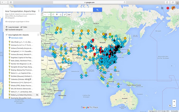
Asia China Mongolia Transportation - Airports & Railroads Satellite Map
This Satellite Image provides an overview of all International Airports in Asia, all Airports in China (PRC) and Mongolia. In addition all military airbases in China (PRC) listed.
Navigate map and click pins for additional information and video where available. Link through from any pin to location information and backgrounds.
Overview all transportation in the Peoples Republic of China and additional Asian Nations in one glance.
Direct Hotel & Resort booking + additional packages linked by location across China, Mongolia and neighboring Asian Nations.
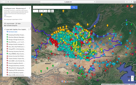
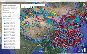
Asia Report - Map of the Peoples Republic of China
This Google supported Satellite Map provides a clear overview of thePeoples Republic of China, including all Provinces, All Cities and all Counties. Marked on the map for orientation are main geographical features such as mountains, mountain ranges, rivers, lakes, major National Capitals, locally relevant cities, all county towns and additional villages, names of oceans, islands in the South China Sea. In addition, transport is highlighted with the location of all International and Local airfields, as well as military air bases, nd train stations (where available). The final layer is reserved for historic monuments, landmarks, tourism locations, etc.
Browse the map and follow the links to more information, maps and photos of each location.