China Report - Map of the Great Wall during the Ming Dynasty
Satellite image of China and North-East Asia, with a super-imposed schematic Map of the location and Path of the Great Wall as constructed during the Reign of the Ming Dynasty. Included for reference are City names, geographical features of landscape, Names and locations of Passes on the Great Wall of China.
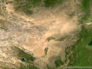
Map of the Gobi Desert & Yellow River Flow
Satellite Image Map of the Gobi Desert Region. Map overviews North-West Xinjiang Autonomous Region, Mongolia, Inner Mongolia and North and North-Eastern China giving a Full Overview of the Gobi Deserts and Yellow River Basin. Map includes country borders, name + location of Cities and Villages (clearly visible).
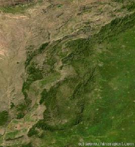
Satellite Image Map Overview of Shanxi Province revealing its mountainous nature. In the southeast, east and north east and center of the Province mountain ranges extend providing major obstacles for travel
- Full Image come soon !
Find DrBen and ChinaReport on Facebook with the latest from www.drben.net.
The second river by size and importance within Shanxi Province is the Sanggan River ( 桑干河). The Sanggan River is a river of regional importance in north China's Shanxi and Hebei Provinces and also counts as one of the older known rivers in Chinese civilization. As early as the 7th Century it was lauded in a Poem by the Poet Chen Tao, himself a literati who's poetry is included in the anthology of 300 Tang Poems, which is considered the absolute top of production in a time and a culture well known for its poetic streaks.
In addition, the during the early history of the Ming Dynasty, an event of incredible importance to the Chinese State occurred at a location not too far from the Sanggan River. This incident was the so called Tumu Crisis.
On September the 1st of the year 1449 AD, only some 80 years after the first establishment of the Ming Dynasty, the Chinese suffered the great humiliation of having their Emperor seized and held hostage by the opposing side, at the time a fresh branch of Mongolians known as the Oirats (Oirat Mongolians). Interestingly, although an entire Chinese Army had been wiped out during their attempts to safeguard their Emperor, the greater crisis that occurred afterwards was a result of the political scheming triggered by the fact that the Emperor was not dead, yet completely absent from his Throne. In the aftermath, for decades, the Ming suffered from inner strive, while eventually, the captured Emperor Yinzhong (Reign: Zhengtong) would return to his Palace in Beijing to rule for another day in an unprecedented second reign period. As one may imagine, the whole affair left deep traces in the Chinese historic and cultural memory and therefor has been much discussed in literature and among the people in general for centuries since.
Thus, although little known by name outside the Peoples Republic of China, Nationally the name of the Sanggan River is familiar, especially to many Chinese of the older generation who lived through the early Revolution and the Mao Zedong Era of the Peoples Republic.
With a legacy as the cradle of Chinese Civilization, mother river but also sorrow of the Nation, the magnificent Yellow River dominates not only the history of the last 3 millenia or more, it also created much of the landscape and throughout the ages has shaped life within Shanxi Province.
Situated in on the eastern rim of what is known to geologists and geographers as the Yellow River Basin, the Province owes much of its loess soil and cliffs, and its dusty appearance to the Yellow River. Find the yellow River as it forms the
western border of Shanxi Province with in the west on the opposite side the Province of Shaanxi.
In the south the Yellow River turn eastward, thereby also forming the natural borders with Henan Province. On the southern side of the river lie the great ancient metropolises of the Han and Tang Dynasties, the city of Luoyang - a capital of the (Western) Han Dynasty, Zhengzhou and Kaifeng (in history Biangliang).
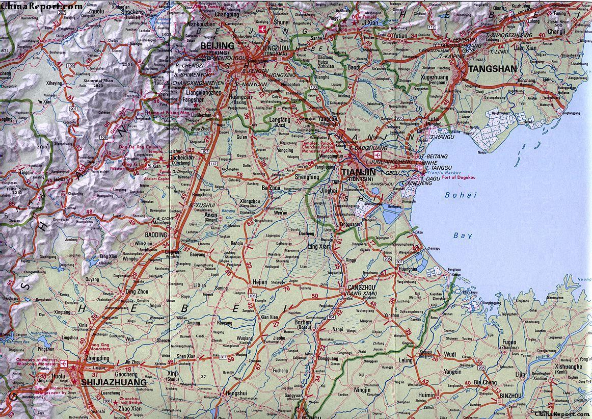
Beijing Regional Map : Beijing-TangShan-TianJin-ShiJiaZhuang quadrangle, an overview of Beijing Municipality (in Hebei Province) and Area to the East and South-East of Beijing. In the top left corner one can easily recongnise the path of the Sanggan River as it flows from Datong Prefecture in Shanxi Province and the Heng Shan (Mts.) into Zhangjiakou (Kalgan) Prefecture to meet up with the Guanting Reservoir which lies just outside of the Great Wall of China and the outer borders of Beijing City Province. The Sanggan River thus is one of the main water resources of the National Capital.
instead turns eastward at considerable distance to the south of the city of Datong.
In these regions the Sanggan River receives both the Kuoquan River and the Yu river as tributaries.
Curving around the famous Holy Mountain of Hengshan which lies to the south-east of Datong, it flows eastward into Zhuolu County (涿鹿县) of Zhangjiakou Prefecture of Hebei Province eventually to empty into the Guanting Reservoir due north-west of the city of Beijing.
Thus, the river is one of the rivers that provide water to the ever thirsty and growing National Capital of Beijing.
As avid travelers will find, the main railway line from
Beijing to Datong follows the Sanggan River upstream and traces its ravines through mountains considered practically innavigable and impenetrable for humans and animals alike up to the advent of the railway and the tunnels carved though the main mountain obstacles, providing for spectacular sights. Although today no one raises an eyebrow over it, at the time - during the early years of the Peoples Republic of China, carving a railway through Heng Shan was considered quite the achievement. It is in fact, as views of spectacular cliffs and ravines will demonstrate along the way.
After reaching the Guanting Reservoir the waters of the Sanggan He (桑干河) and also the Yang He (洋河) eventually become part to the Yongding River, one of the major rivers in northern Hebei Province and the city Province of Beijing.
Altogether the Sanggan River has a length of some 290 kilometers (180 miles) and a drainage area of around 48.000 square kilometers (18.500 miles), covering much of north Shanxi Province.
RIVERS IN SHANXI PROVINCE BY REGION AND PREFECTURE:
Eventhough Shanxi Province ranks among the most arid Provinces in all China and only the provinces and autonomous regions of the west and far west see less rainfall, there are a multitude of smaller rivers and streams that flow out of the high mountain ranges that cut across the rough terrain of Shanxi Province.
A complete overview of all rivers and streams is ny well impossible, however the main rivers for each part of the Province and each (City) Prefecture of Shanxi Province have been listed on their own seperate pages. Please select below:
*) Rivers of North East Shanxi Province - Datong Prefecture
*) Rivers of North Central Shanxi Province - Xinzhou Prefecture
*) Rivers of North Central Shanxi Province - Shuozhou Prefecture
*) Rivers of Central Shanxi Province - Taiyuan Prefecture
*) Rivers of South East Shanxi Province - Changzhi Prefecture
*) Rivers of South East Shanxi Province - Jincheng Prefecture
*) Rivers of East Shanxi Province - Jinzhong Prefecture and Yangquan Prefecture
*) Rivers of West Shanxi Province - Lüliang Prefecture
*) Rivers of South West Shanxi Province - Linfen Prefecture
*) Rivers of South West Shanxi Province - Yuncheng Prefecture
RESERVOIRS IN SHANXI PROVINCE:
Taken from north to south, the first of the main water reservoirs within Shanxi Province is the Wenyinghu Reservoir which is situated on the eastern outskirts of the city of Datong in Datong Prefecture of north Shanxi Province. Situated at a relatively high altitude and in otherwise arid regions, together with the local rivers Shili He and Yu He, the reservoir forms the main watersources of the city of Datong.
At some distance due southwest of Datong lies the Xiamizhuang Reservoir of the Kuoquan River.
The Taipingyao Reservoir, which is formed by the Maquan River and Qili River lies due est of Shuozhou City in Shuozhou Prefecture. Many kilometers further downstream along what by then is named the Sanggan River lies the more minor Dongyulin Reservoir.
In Xinzhou Prefecture in central Shanxi Province the main reservoirs are the Mijiazhai Reservoir, Shangru Mountain (Shangrushan) Reservoir and Faxing Reservoir.
Mijiazhai Reservoir and the somewhat larger Shangrushan Reservoir lie to the northwest of Xinzhou. The Faxing Reservoir lies in the loess hills to the southwest of the city.
In Changzhi Prefecture in south west Shanxi Province the main reservoir is the Zhangze Reservoir of the Shizhi River) which lies on the north western outskirts of the city of Changzhi. Fed by several regional rivers this is by far the largest reservoir in this city prefecture. Nevertheless, various other man-made reservoirs have been established on the tributary rivers feeding into Zhangze Reservoir and a few other streams.
From north to south these are: Houwan Reservoir of the western branch of the Zhouzhang River (Zhuozhang Xiyuan), Tunjiang Reservoir of the Jiang River (Jianghe), Zhangze Reservoir of Changzhi City, Baojiahe Reservoir of the Lanshui River (named after the village BaojiaHe not any river), Shencun Reservoir of the Longsi River and finally the Taoqinghe Reservoir of the river by the same name.
A few more local reservoirs exist in the extreme south west just beyond the borders of Changzhi Prefecture within the northern parts of Jincheng Prefecture. These are Zhaozhuang Reservoir and the even smaller Fushan Reservoir which drains into the Dan River (Dan He). Further down south but at a considerable distance north west of Jincheng City lies the Renzhuang Reservoir also of the Dan river.
Other than these Jincheng has no water reservoirs due to the extreme mountainous nature of most of its territories.
CANGQIAN RIVER (A.k.a. Yongding River):
The Cangqian River is another never mentioned river in Shanxi Province of major importance. The Cangqian river has its source in the Guancen Mountains (管涔山) which are found in Ningwu County, an area most renowned for its historic NingwuGuan Pass of the (Inner Layer) of the Great Wall of China. The Ningwu Pass (also Xinzhou Pass), named after the small village that sits along a steep ravine in the Loess Plateux, is famous in China not only for
its Great Wall Pass and Gate, but also as a battlefield of the anti-Japanese War and the Civil War(s). As such, Ningwu County is a well known location throughout the Chinese Nation.
(For more information on the Ningwu Pass and the various historic Battles see also: ”History of Shanxi Province and NingwuGuan / Ningwu Pass o/t Great Wall of China”).
From its source situated in the Ningwu County of Xinzhou Prefecture of Shanxi Province the Cangqian River flows away from the mountains in a Generally northern direction where it eventually reaches into the Inner Mongolia Autonomous Region.
After passing through Inner Mongolia the river turns southeastward into Hebei Province and eventually empties into the Guanting Reservoir and passes to the inside of the Great Wall of China in Hebei Province (Parts of the wall lie submerged in Guanting Lake).
The fourth river of importance for travelers purposes within Shanxi Province is the river Fen. The river Fen is a river in central and western Shanxi Province which flows out of the loess hills to subsequently pass roughly from north to south through the Capital city of Taiyuan. Furthermore downstream the Fen river also lends its name to the city of Linfen, as noted notorious among the most polluted destinations within the Province and even larger Nation.
As a result, mostly of the notoriety of Linfen as pollution
ground zero, the river Fen accordingly has become internationally (in)famous. You may therefor already have heard its name previously. In case you had not, watch adjacent video excerpt from the longer documentary: ”Toxic Linfen”.
Apart from being the largest river in the Province, notoriously suspect of severe pollution, and a destination and sight for those interested disaster tourism or the downsides of Chinese Economic Development, the river Fen has even more tales and stories attached to it than does the Sanggan River in north Shanxi.
When it was published, the Novel: ”The Sun Shines over the Sanggan River”, was initially a National and even International success receiving the Soviet Union’s Stalin Prize (for Literature) in 1951 as the first Chinese Book ever to do so. However, after the censoring of Ding Ling by the Chinese Communist Party, the book subsequently disappeared from circulation. Today, except for a few historic literature buffs, no one would probably take its contents very seriously, however the title of the Novel and the tales told in it, still cling to the river today as a mirage from a bygone era. A mythical tale from a seemingly romantic era of dire struggles describing a world that should have been but never quite was.
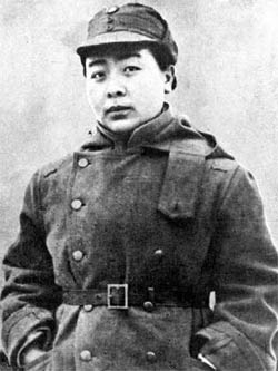
At the time, in 1948/49, the river featured prominently in the ”Proletarian Novel” of the talented Ding Ling, who was the only woman intellectual to debate Mao Zedong on equal terms and audacious enought to lecture him on Women's rights. Needless to say, eventually this would land Ding Ling in trouble with ”the Law”, being Mao's ever Rising Red Star.
A Photo of Ding Ling reflecting much of her personality, intellect and general zeal.
Although considered not as pretty as for instance the later Madame Mao (Lan Ping= Blue Apple), Ding Ling was certainly among the most intelligent women in the Communist Base of Yanan as was seemingly partially recognized by Mao Zedong. Ding Ling was among the very few who could visit the Mao Cave and open debates with Mao Zedong.
The Sanggan River runs in the northern central and north eastern parts of Shanxi Province. Springing from its source, the Taipingyao Reservoir at the confluence of the Qili River (Qili He) and the Hui River (Hui He) due east of the city of Shuozhou the Sanggan River flows through the Shuozhou Prefecture in a generally north eastern direction. Along the way it receives the the waters from the Maquan and Yuanzi Rivers as a tributary and meets the Dongyulin Reservoir further downstream. The Dongyulin Reservoir is another man-made marvel and reminder of the times of Revultionary zeal lived through by Ding Ling and
her generation. Virtually by power of the hand and the flock of the masses, a dam was built to stop the drainage of the Sanggan River, so creating a reservoir that could serve to irrigate the fertile but too arid highlands of northern Shanxi and turn them into breadbaskets of the Nation and the pride of the people. Naturally, as we now know, the agricultural miracle never quite happened although the reservoir sure did serve its purposes.
Winding its way northeastward and passing across the prefectural borders into the Datong Prefecture the Sanggan River does not reach Datong city but
YouTube Video: CNN Excerpt from Documentary: Toxic Linfen by Vice News.
SHIZHI RIVER:
As with the river Fen, the Shizhi River lends its name to Changzhi, the city and prefecture which lie due south east of the Capital Taiyuan on the opposite side of the Province as Linfen. As such, the Shizhi River ranks fourth in importance among the rivers of Shanxi Province.
Mind you, although generally arid and hilly or mountainous in nature, there are several more rivers of interest crossing the Province and its Prefectures. They are briefly listed below on an especially dedicated pages as part of the Geography section on Shanxi Province.
Although not among the main rivers to know about for the average tourist traveling about Shanxi Province, three further rivers might be mentioned.
HAI RIVER:
No information available.
QIN RIVER:
Although little known to foreigners, the Qin river (沁河) flows through Changzhi Prefecture, Jincheng Prefecture and part of the extreme north of Henan Province. Altogether, it is an impressive 485 km long and has a drainage area of 13,500 square kilometers.
No Notable tourist landmarks or scenic sights are found along its trajectory however.
FOR ALL INFORMATION ON THE QIN RIVER, PLEASE REFER TO:
The main river in Shanxi Province is the Yellow River (Huang He) although strictly speaking it forms the (natural) borders of the Province and does not flow through the Province but instead forms the natural western and southern borders of much of Shanxi Province. The Yellow River, with a total length of over 5000 miles, is by far the largest river found within the wider regions.
ZHANG RIVER:
The Zhang River (漳河; Zhang He) is a river found in the south western extremes of Shanxi Province. It finds its source in Jincheng Prefecture and has a generally eastward trajectory. The Zhang River is of historical interest because it contributes its waters to the so called Red Flag Canal, which was a political pet-project of the 1960's and the Revolutionary Era now gone. The Red Flag Canal is a rather remote but currently again much visited tourist gem which however lies on the other side of the mountains and not in Shanxi Province.
In its downstream are the Zhang River forms the border of Hebei Province and Henan Province west of the cities of Handan and Anyang.
In essence, Shanxi Province counts five major rivers, several lesser known rivers and many minor tributaries and streams. For all general travelers purposes, the main rivers in Shanxi Province are the Yellow River (Huang He), the Fen River (Fen He), the Sanggan River, the Cangqian River better known as Yongding River, and the Shizhi River.
In addition, there are the little heard of Hai River, Qin River and the Zhang River.
All other rivers in Shanxi Province are essentially tributaries of these larger rivers.