In essence, Shanxi Province counts five major rivers, several lesser known rivers and many minor tributaries and streams. For all general travelers purposes, the main rivers in Shanxi Province are the Yellow River (Huang He), the Fen River (Fen He), the Sanggan River, the Cangqian River better known as Yongding River, and the Shizhi River.
In addition, there are the little heard of Hai River, Qin River and the Zhang River.
All other rivers in Shanxi Province are essentially tributaries of these larger rivers.
Find DrBen and ChinaReport on Facebook with the latest from www.drben.net.
RIVERS IN SHANXI PROVINCE BY REGION AND PREFECTURE:
Eventhough Shanxi Province ranks among the most arid Provinces in all China and only the provinces and autonomous regions of the west and far west see less rainfall, there are a multitude of smaller rivers and streams that flow out of the high mountain ranges that cut across the rough terrain of Shanxi Province.
A complete overview of all rivers and streams is ny well impossible, however the main rivers for each part of the Province and each (City) Prefecture of Shanxi Province have been listed on their own seperate pages. Please select below:
*) Rivers of North East Shanxi Province - Datong Prefecture
*) Rivers of North Central Shanxi Province - Xinzhou Prefecture
*) Rivers of North Central Shanxi Province - Shuozhou Prefecture
*) Rivers of Central Shanxi Province - Taiyuan Prefecture
*) Rivers of South East Shanxi Province - Changzhi Prefecture
*) Rivers of South East Shanxi Province - Jincheng Prefecture
*) Rivers of East Shanxi Province - Jinzhong Prefecture and Yangquan Prefecture
*) Rivers of West Shanxi Province - Lüliang Prefecture
*) Rivers of South West Shanxi Province - Linfen Prefecture
*) Rivers of South West Shanxi Province - Yuncheng Prefecture
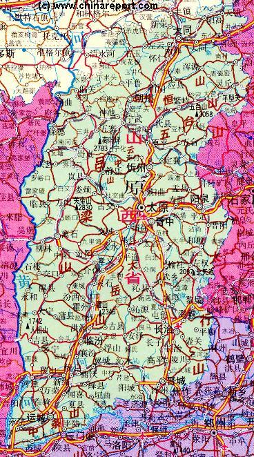
Although little known to foreigners, the Qin river flows through Changzhi Prefecture, Jincheng Prefecture and part of the extreme north of Henan Province. Altogether, it is an impressive 485 kilometers long (some 300 miles) and has a drainage area of 13,500 square kilometers.
The largest tributary of the Qin River is the Dan River (丹河 ; Dan He) but the Qin River has many tributary smaller rivers. No notable tourist landmarks or scenic sights are found along its trajectory in Shanxi Province. There are also virtually no interesting historic events that can be reported to have taken place at or near the Qin River in Shanxi Province, however this is entirely different for the lowest reaches of the Qin River which have at least one spot of substantial interest. As below story will describe this is the Mang Mountain, which for Chinese with a passion for the Communist Party and its history has some interesting rales attached.
HISTORY OF THE QIN RIVER:
According to the Encyclopedia Brittanica, The Qin River’s lower course has a very low gradient, so that the large volume of silt carried by the river down from the loess plateau has caused extensive flooding since ancient times. It should be noted that the encyclopedia Britanncia speaks especially of the lowermost parts of the river, which run south of the Taihang Mountains and within Henan Province, where near the confluance of the Qin River and great Yellow River the build up of water volumes was the worst. No such flooding problems exist on the loess plateaux in Shanxi Province where the river naturally carves its valley through the soft ground while losing some 1500 meters in altitude.
Encyclopedia Brittanica notes how just before the advent of the rule of the Tang Dynasty (618 AD - 907 AD), in the year 609 AD, an attempt was made to dig a canal from lower flow of the Qin river northwards in the direction of the city of Anyang (Henan), via Baoding (Hebei) and then to Beijing (which was not a large city at the time). This canal, recorded to have been named Yongji Canal started somewhere in the area of Wuzhi (Today: Wuzhi, Wuzhi County, Jiaozuo Prefecture in Henan Province) along the Qin River working in a north-eastward direction toward the nearby Wei River. It is noted that after this canal had been completed the waters of the Qin River were diverted via the Canal. The canal, however, fell into disuse at the end of the 8th century for unclear reasons. Most likely the Yellow River shifted its banks, or otherwise, the build up of loess sediment on the bottom of the canal lifted it until no more water would flow, a problem commonly encountered throughout the times with rivers in the Yellow River Basin.
Some 12 centuries later, just after the establishment of the Peoples Republic of China and during a New Era of massive public works and infrastructural projects a fresh attempt to link the Qin River with the Capital of Beijing up north was undertaken. The construction was done not by ”The Government” but almost exclusively by local farmers, who acting upon their responsibility to increase agricultural output and ”strengthen the nation” built everything under the leadership of local party cadres and of course, the watchful eye of the Nationally empowered Communist Party of China.
In the years 1951–52 the People’s Victory (人民胜利渠 ; Renmin Shengli) Canal (Qu) was constructed in the southernmost reaches of the Qin River in the area between Jiyuan and Jiaozuo Cities in north Henan Province also starting near Wuzhi. The construction of this Canal was the first such large scale water management project undertaken by the New Peoples Republic of China and as a result much noted as a pet propaganda project. The Victory of the People’s in this case would be to turn away the age old dangers of flooding, thus taming the notorious Yellow River (and its trubtaries). On top of that, the powers of the river would be tmaed and turned for the good use of irrigation in agriculture. It was envisioned that the great canal project would substantially improve the yields of surrounding farm lands. According to those who were there at the time, the building of dykes and canals on the Yellow River became the great common cause of the people, one of the first drives to unify the new populace while meanwhile increasing the standing of the Communist Party. Among things, the People’s Victory project was noted for its first time large scale inclusion of women among the (mostly manual) laborers to build the dykes and canals. In Nationally distrubuted tales they were renowned as the Women's Yellow River Dyke Brigade.
Succesfully completed already in the year 1952, the People’s Victory canal finally reopened the earlier Sui and Tang Era Canal of the year 609 AD and by allowing the Qin River to drain into the Wei River (Henan not Shaanxi!) it waters could be diverted or syphoned off when the Yellow River ran high and at the same time the Qin River filled up with water running off the Shanxi Loess plateaux creating a crisis in the low farm lands along both rivers. In the past millenium, devastating floods had occurred frequently in this lowlying region along the banks of the Yellow River.
As the prestige attached to the project was wipped up for political puproses across the Nation, it was almost inevitable that eventually Mao Zedong himself came to inspect the Yellow River works and with it the Qin to Wei River canal. On his first ever inspection tour after the establishment of the Peoples Republic of China, Mao toured works along the Yellow River in Shandong Province, among things highlighting the villainous acts
To be more precise, the Qin River source is found in the Taiyue mountains near Jiangtai in Qingyuan County of Changzhi Prefecture.
Heading downstream from its source, the first village found along the river is Hedi (河底 ). Many kilometers downstream from Hedi the river enters the modestly sized Taiyueshan (Taiyue Mountain) National Forest Park.
Along the convoluted and lengthy route of the Qin River a multitude of other rivers are met, all to join the in River on its course down south to the Yellow River (Huang He) in Henan Province.
At the town of Gudao (Zhen) the Qin River meets its first tributaries and the S222 Provincial Road. Both tributaries flow in from the north. The first tributary is the Chishi River, the second is the Zizhong River.
Turning due southward the river flows through hills and rural lands for many kilometers before meeting another tributary at the town named after the river, QinHe (Zhen). In the north of Qinhe Town the Langweihe Canal joins from the north west.
On the trajectory of the river between Qinhe Town and Anhe Town, the Baizhi River (Baizhe He), the Lin River (Lin He), and the Liyuan River (Liyuan He) join the flow of the Qin River from the west.
At Anhe Town the Guxian River (Guxian He) and the S309 National Road come in from the west, the Guxian River emptying into the Qin River while the S309 Road follows the valley of the Qin River in a due south eastern direction.
Someways beyond the next rural town, named Jishi (Zhen), the Si River (SiHe) and Lan River (Lan He) join as tributaries from the north east. In the next lengthy
QIN RIVER IN JINCHENG PREFECTURE:
In Jincheng Prefecture the Qinshui River joins from the east, followed downstream by the Guxian River coming from the north west. The last river to contribute its waters to the Qin River in Jincheng Prefecture is the Huze River (Huze He).
From the joining point of the Huze River, the Qin River enters a mountainous trajectory that takes it across the border into the northern extremes of Henan Province.
The Qin River (沁河; Qin He) has its source in the mountainous terrain of Qinyuan county which lies in Changzhi Prefecture in the south west of the Province. This river is noted as a minor tributary of the lower Yellow River (Huang He) which it joins at a point east and downstream of Luoyang, the ancient Western Han Capital in Henan Province.
southward path through the low parts of the mountains the Qin River enters into Jincheng Prefecture of Shanxi Province where it next meets the Shicao River (Shicao He) and Longqu River, both tributaries that join the Qin River.
Xinxiang
Today People’s Victory Canal is still open and in use.
The starting point of the Canal can be found at the village of Qinchang (秦厂村 ), in Wuzhi County of Jiaozuo City.
MAIN TOWNS ALONG THE QIN RIVER IN SHANXI PROVINCE:
Main towns found along the Qin River in Shanxi Province are QinHe (Zhen), Anhe (Zhen) and Lishi (Zhen).
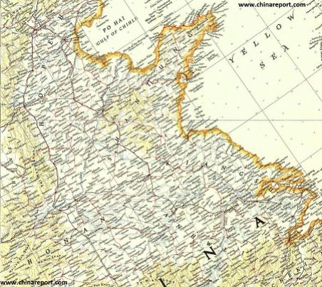
China - Historic Map - Shandong, Jiangsu, Anhui Provinces in 1953
A large Geographic Map depicting parts of Shanxi, Hebei, Shandong, Henan, Jiangsu and Anhui Provinces of China in the year 1953 AD. Clearly visible is the trajectory of the Qin River flowing from Shanxi southward into Henan and then eastward past Jiyuan and Jiaozuo Cities to meet up with the Yellow River. The River Wei, connected to the Qin River by the Peoples Victory Canal is also identified on this map.
perpetrated by his enemies, the treacherous Kuomintang who without regard for the peasants lives had blown up dykes and dams in the regions in attempt to stop Communist Armies from heading down south towards their final victory in the Civil War. However, the main purpose of the tour was to underpin the initiated central party line that with the will of the party leadership and the people combined, China - a country of many ancient woes - could be transformed for the better. In case, the age old sorrow of the seasonal floods of the Yellow River would be dealt with and the waters of the rivers put to use in agriculture. Afterall, having only recently completed a century of misery and warfare, the nation was destitude and millions went without proper food or clothing.
Winding up his tour of the yellow river in the North China Plain, Mao eventually ended up at the head of the Canal on the Qin River which at the time was only known under the name Yellow River Irrigation and Diversion Project.
Having seen with his own eyes the succesful taming of the rivers waters in the Canal Mao let know to the assorted officials and reporters that each Province and Region should have such examplary (water control) facilities.
Although to some these may seem like mere words of encouragement, a politically correct statement showing appreciation, at the time in
China these words coming from a Man who by many was regarded as the New Emperor carried enormous weight. Hence, as a result of the widely publicized tour and the visit to the canal, the Yellow River Diversion Project suddenly became the People's Victory Canal and in the years following the name of canal resounded throughout the land putting the river Qin and its Canal onto a course of even greater fame.
Famously, at the end of the 1952 Tour Mao Zedong was photographed for the occasion at Mang Mountain near the confluence of the Qin River and the much larger Yellow River. At this spot, not too far downstream and due north of the city of Kaifeng, Mao seems to envision even greater plans as always - the greatest, if not the impossible for the Nation he so much identified himself with. For Mao no challenge was too great, and as later large scale projects such as among things the ”Red Flag Canal” (between Shanxi and Henan, due west of Anyang city) illustrate, if need be, mountains would move when faced with the united will of Chinese people, his beloved ”masses”.
Legend has it, that the 1952 tour of the Yellow River flood control works in the North China Plain and the overviewing of the river at Mang Mountain eventually led to greater thoughts, among things the diversion of rivers on a National scale. Having instructed Wang Huayun, the director of the combined Yellow River Works Committee, to ”think big” (not small alike his means), Wang is supposed to have proposed the diversion of the waters of the Yangtze River and valley to uses in the much more arid regions of North China.
As such, the People's Victory Canal is regarded as the mother project for the much larger water control projects of the modern era, most notably the Three Gorges Dam of the Yellow River as well as the south-to-north water diversion project which today has only partially been completed.
Although Mao never returned to the Mang Mountain (or at least not publicly) and the Qin River he made them instantly famous. The Great Helmsman, National Leader and according to some visionary man would return to tour the North China Plain in 1953 and 1954 in order to urge more work in reconstructing the flow of the Yellow River and it associated tributaries.
Qin River (沁河) in Henan Province of China
QIN RIVER IN HENAN PROVINCE:
Via the southern outer limits of Jincheng County of Shanxi Province the Qin River enters into Jiyuan (济源) Prefecture and with that crosses into Henan Province.
The border lies at the village of QuShou (渠首村 ; Qu Shou Cun) which still lies within the southermost spur of the Taihang Mountains.