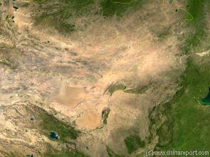
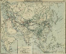
A Satellite Image Map of the Entire Gobi Desert Region and the realtive position of the City Datong in it. Map overviews North-West Xianjiang Autonomous Region, Mongolia, Inner Mongolia and North and North-Eastern China giving a Full Overview of the Gobi Deserts. Clearly visible details of geographical features such as mountain ranges, rivers, valleys and lakes, national borders, name and location details of Cities and Villages (clearly visible).
Mouse over Image to Reveal more information and follow the flow and path of the yellow river from Xining in Qinghai Province to the Bohai Sea. Details of old / former Yellow River flow (south of new) and new trajectory to the Bohai Sea.
The Tibet Autonomous Region (西藏自治區) Maps Index gives acces to all Maps relevant to Tibet AR + Qinghai, larger Tibet (Nation of Tibet) & Area's of Specific Interest within that Region, as used and/or produced by ChinaReport.com. Please use these Maps to find your way easily around the Region, Cities, Area's and many Monuments & Landmarks.
A Satellite image Based Map of China and East-Asia, with a super-imposed schematic Map of the Location and Path of the Great Wall as constructed during the Reign of the Ming Dynasty.
Included for reference are Locations and Names of Passes on the Great Wall of China and their significance. Further Reports link to More Photos and History & Backgrounds of each Great Wall of China Site. Further depicted are City names, geographical features of landscape, rivers and more.
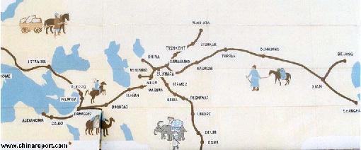
Map of the Ancient Silk Road during the Han Dynasty & Roman Age 2
A Schematic Map depicting the Full Length and main pathways of the Ancient Silk Road during the Han Dynasty Period (206 BC - 221 AD) and Roman Age (30 BC - 630 AD).
In 30 BC the Roman Empire started trading with India, which was already well known from the
Conquest of Alexander the Great (+/- 330 BC). In the following 6 centuries the West would Trade with India and indirectly also with China through the Silk Road. The Silk Road only lost its Value after the European Age of Discovery and the Establishment of Maritime Trade Routes with India (16Th Century) and later China. The Yellow River is crossed at Lanzhou, after which Dunhuang is the Last Station in China.
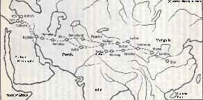
Map of the Ancient Silk Road during the Han Dynasty & Roman Age 1
A Schematic Map depicting other details along the Full Length and main pathways of the Ancient Silk Road during the early Han Dynasty Period (206 BC - 221 AD).
As seen from China the Silk Road extends due Westward from Chang'An (Xian) the Han & Tang Dynasty Capital. The Yellow River is crossed at Lanzhou, after which Dunhuang is the Last Station. This
Map depicts the Lost Civilizations of Loulan and Hotan, as well as the south route and north route of the Silk Road coming together at Dunhuang in current day Gansu Province of China.
Geographic Maps of the the Tibetan Plateaux, Himalayas Mountains, The Nation of Tibet + borders, The Great Wall of China including in and near Tibet, and various other historic maps relating to Tibet and Tibet AR.
All Maps relevant to Tibet & Tibetan History
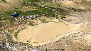
Map o/t Taklamakan Desert & Tarim River Basin (in Xinjiang-Uygur AR)
A Satellite Image Map of the entire Taklamakan Desert and the Tarim River Basin in Xinjiang-Autonomous Region of Western China.
Map gives explanation and backgrounds to Local Geography, the Flow of the Tarim River from the Pamir Mountains in the West to Lop Nur (Dry) in the East, ancient Oasis Cities of the Tarim Basin and Taklamakan Desert, the North and South Routes of the Silk Road in this Area, Past and Current Climate and Historic Backgrounds.
China Report - Map of China in the Age o/t Han Dynasty 2nd Century BC + Trade Routes
A Schematic Map depicting the Full extends of the Han Dynasty Empire and its trade relations with neighboring States and Neighboring Peoples and Tribes.
Marked on the Map are the locations of Main Cities of the Han Empire, Han Military Garrisons and Strongpoints, locations of Tributary States (mainly in the West) and the Pathways of Sections of the Great Wall of China constructed during the Han Dynasty Reign Era.
Special Links provide access to additional information on each individual site.
Map Yuan Dynasty Mongol Empire in Time 1206 AD - 1294 AD
A Schematic Map of the Mongol Empire of Genghis Khan (TeMuJin) and descendants through its several stages of conquest in its short but Impressive Existance in History. Timeline depicts the Mongol Conquest starting in the Year 1206 AD, when Genghis Khan first united the Mongol-Turkic Tribes of Mongolia and Lake BayKal becoming Great Khan. The Timeline continous through the year 1219 AD, the year 1223 AD taking Transoxiania, 1227 AD, 1237 AD when the Northern Jin Dynasty of China was annihilated, 1259 AD conquering ancient China above the Yangtze River and 1279 AD when all of China was taken and the Yuan Dynasty Eastablished under the Kubilai Khan. Last is the Year 1294 AD when the Mongol Empire reached its largest geographical size and Zenith, 22% of world land area, but through lack of central leadership and over-expansion fragmented into 4 large parts, then imploded upon itself.
Asia Report - Map Trade Routes in Asia in the 13Th Century
A Schematic Map of the Eurasian Trade Routes existing in the 13Th Century. Clearly marked in Red Accent on the Map are the cities of the network of land-bound trading routes through Central Asia known as the Silk Road (the path of Marco Polo and others). Marked in Blue Accent are the Main Ports and Harbors of the Maritime Trade Routes that operated between the Arabian Peninsula and the Red Sea, the Indian Ocean and Coastal Cities, the Straights of Malacca, the South-China Sea's and beyond. As shown Maritime Trade to China mainly entered through Southern Harbors, then was distributed internally by use of the Grand Canal, the Yangtze River and the Yellow River.
Map includes the Route travelled by Marco Polo, William of Rubruck and John of Pian de Carpine, the three famed European Travelers of the Time.
Locations of Main Trading Ports and Cities on Trade Routes of the Time are marked.
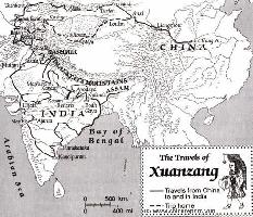
This Schematic Map shows the entire "Journey to the West" as made by the Chinese Monk Xuanzang in the years 629 AD to 645 AD.
The Path of the Journey to India led though China, Kyrgyzstan, Tajikistan, Afghanistan, Pakistan and India. The Return Journey led through Pakistan and Afghanistan to reach Kashgar in current day Xinjiang-Uyghur Autonomous Region of China. Because the (Han) Chinese Cultural Zone during the Tang Dynasty Era only reached as far as Dunhuang, where the Great Wall began, Xuanzang had to travel south-east from Kashgar via Yarkant and Hotien (Khotan) along the South Route around the Taklamakan Desert to finally return to his native China in 645 AD.
Map - Travel Route of Xuanzang - Journey to the West
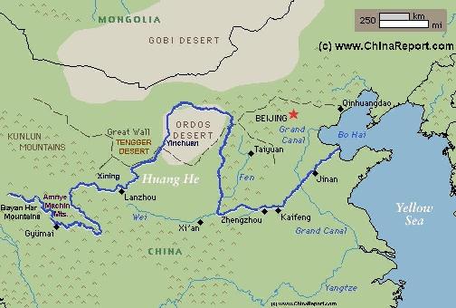
Schematic Map of the Yellow River Flow Path 01A
A Full Schematic Map of the entire flow path of the Yellow River. Map overviews Qinghai Province, Parts of Sichuan Province, Gansu Province, Ningxia Hui Autonomous Region, parts of the Republic of Mongolia, Inner Mongolia Autonomous Region, Shaanxi Province, Shanxi Province, Henan Province and finally Shandong Province, giving a Full Overview of the length of the Yellow River. Clearly visible details of geographical features such as mountain ranges, rivers, valleys and lakes. The Map includes main cities along the River, popular and famous scenic spots, the dams and water reservoirs on the Huang He and other relevant informations.
Click the links to find more information on each individual location !
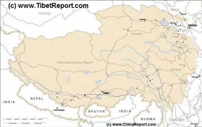
MapTibetHistoricalBorders
A Schematic Map of Historical Tibet, today Tibet Autonomous Region, Qinghai Province and a part of Sichuan province.
Included for reference are current Internationa Borders, provincial borders, locations and names of main cities and towns, main rivers and lakes, mountains,importantTibetan-BuddhistMonasteries and other places of significance.
Further Reports link to More Photos and History & Backgrounds of each City, Town or Ethnic Community of Yugur, Dongxiang Tibetan, Lhoba, Kazakh, Mongol or others where available.
Today Tibet only exists as Tibet Autonomous Region of China. Tourist visits require an aditional visa !
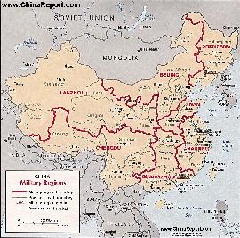
Map China 7 Military Districts (Regional Defense Commands)
Originally thirteen military regions were established in the 1950's, but the number was reduced to eleven in the late 1960's. The resulting eleven military regions - Shenyang, Beijing, Lanzhou, Xinjiang, Jinan, Nanjing, Fuzhou, Guangzhou (including Hainan Island), Wuhan, Chengdu, and Kunming - were reduced to seven intheperiod 1985-88 AD. Currently,the active military districts include Lanzhou- including the former Urumqi MR, part of the Himalayan Mountains in North-West Tibet andAksaiChin, Chengdu Military Region including the former Kunming MR, Nanjing, which includes the former Fuzhou MR, Beijing, and Shenyang. Finally Guangzhou and Jinan Military Regions both appear to include parts of the former Wuhan MR.
The military regions arefurther divided into military districts, usually contiguous with provinces, and military sub-districts.
MapTibetHistoricalBorders
A Schematic Map of Historical Tibet, today Tibet Autonomous Region, Qinghai Province and a part of Sichuan province.
Included for reference are current International Borders, provincial borders, locations and names of main cities and towns, main rivers and lakes, mountains,importantTibetan-BuddhistMonasteries and other places of significance.
Further Reports link to More Photos and History & Backgrounds of each City, Town or Ethnic Community of Yugur, Dongxiang Tibetan, Lhoba, Kazakh, Mongol or others where available.
Today Tibet only exists as Tibet Autonomous Region of China. Tourist visits require an aditional visa !
Eurasia Map - Colonialism - Growth Colonies & Japan after 1801 AD
A Map drawing of the Eurasian continent , parts of North-East Africa and the Middle East in the 19Th Century between 1801 AD and 1900 AD. Focal points are the expansion of western colonial posessions of Portugal, Britain and France, as well as Russia moving from West to East. Labeled seperately is the later Rise of the Empire of Japan in the East.
Included in this Map are the main cities across the continent with their brief histories and events during the 19Th Century. Marked in Colors for clarity are the various colonial and imperialist Nations. As relating to China; special attention is payed to so called Treaty Ports. The First Treaty Ports were forced open by Britain in the year 1841 AD, but counted over 80 in total by the end of the 19Th Century. The most important Treaty Ports in China are marked and described with a short history where the map allows. Follow the links for more information on each location and subject.
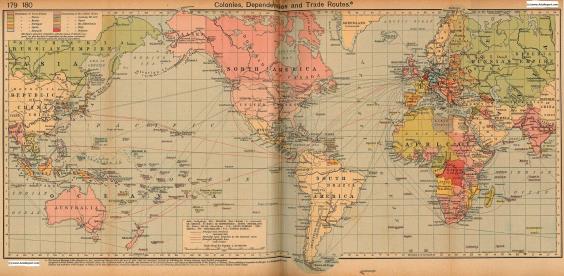
Colonialism - 1912 World Map Colonial Possessions & Trade Routes
A Map drawing of the World depicting the Colonial Possessions as they were distributed in 1912 AD. Superimposed and marked in colors are subsequent changes in Influences Spheres, colonies and possessions due to World War I ( 1914 AD - 1918 AD). Further included in this Map are the main cities across the continents with brief histories and events during the late 19Th Century and early 20Th century, where relevant. Marked in Colors for clarity are the various colonial and imperialist Nations. As relating to China; special attention is payed to so called Treaty Ports., the situation in Xinjiang, Tibet, Mongolia and Manchuria.
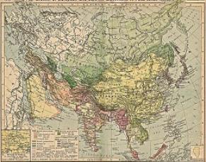
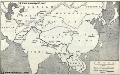
MapHistory - Schematic Asia - Russia China Britain Great Game 1900 AD
A Schematic Map of Historical East Asia at around the year 1900 AD and the turn into the 20Th Century.
Although the Manchu ruled Qing Dynasty Empire had previously conquered large parts of East Asia, including much of Korea, parts of current day Siberia, most of Mongolia, East Turkestan, Kyrgyz, Kazakhs and other tribal lands while subjecting Tibet to a subjugary role nominally ruled for its taxes but yet remote and inaccessible behind its mountainous walls, at the turn of the 20th Century the outer regions of the Qing Empire have been eroded away, much of the north and west increasingly under Russian control while in the south and along the coast Britons and others had fought their way into the Chinese Realm. Notably, Korea has been annexed by Japan and Tibet is shown as a de facto independent territory. Tibet will be invaded by Britain in 1901 AD and will declare Independence not long there after at the fall of
the Manchu Dynasty and the end of Manchu rule over China but also Mongolia and Manchuria in 1911 AD. Other groups such as Mongolians, Kazakhe and Kyrgyz will likewise attempt to reestablish their National independence after the fall of the Manchu Empire.