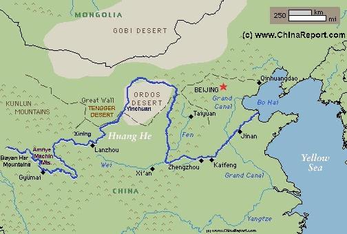
The Path o/t Yellow River through China (1) Upper Reaches ; Qinghai, Sichuan, Gansu.
The Yellow River is China's second longest river, measuring some 5464 kilometers (3.395 miles) in length. It is the world's 6th longest river.
The Yellow River is known in Chinese as Huang He and also as Huang Ho depending on spelling.
The drainage basin of the Yellow River, known as the Yellow River basin, is the third largest of all rivers in China, encompassing a surface area of around 750.000 square kilometers (290.000 square miles)(official: 742,443 km² (290,520 mi²).
It extends 1900 kilometers (1.180 miles) from West to East and 1100 km (684 miles) from South to North.
The China Report
Introduction to the Yellow River (Huang He - 黃河) - China's 2nd largest River
ChinaReport.comat
Madoi
The Path of the yellow river starts in the parts of Tibet today known as Qinghai Province where a small spring originates from the foothills of Bayan Har Mountains in South Qinghai Province (East Tibet) not far from the border with Sichuan Province.
To be exact, the river springs in the form of several streams from the Northern Slopes of the Bayan Har mountains in the Yuekuzonglie-basin at a height of +/- 4500 meters.
The source section, still divided into many seperate streams, flows mainly through pastures, swamps and knolls between the Bayan Har Mountains (巴顏喀啦山脈) and the Anemaqen (Amnye Machin) Mountains.
Generally speaking, although a dusty unpaved road follows the Yellow River upstream for some distance, the very upper regions and wider source area can only be reached by riding animal or with use of tracked vehicles. In this very early section
Schematic Map of the Flow Path of the Yellow River through China.
Gyümai (or Jímài (吉迈) for short, but also known as Darlag) is the main county Town of Darlag County of the huge Golog Tibetan Autonomous Prefecture. The town lies at some 112 miles beyond Madoi along the river and counts only some 400 inhabitants (according to the sparse sources) while the entire county counts only some 30 thousand dwellers (10), many of whom still live a nomadic life-style or attempt to do so. The County of Darlag, the vast area surrounding the town, measures some 15385 square kilometers.
A pristine landscape of a few mountains, rolling hills and waving grasslands devout of any trees accompanies the slow progression of the water of the Yellow River eastward. Traditionally the frigid and extreme habitat of the nomadic peoples of Tibet, there are few or rather no historic buildings or sites to report on or travel to. Even today, the region is considered extremely remote due to the fact that -so far- no major roads have been constructed to lead here. Due to the fact that the Darlag County is (since recently) remote, has few landmarks and has little history that the outside world knows of today - as well as for the extreme climates, hardly any tourists venture there today. The only real reasons for outsiders to travel to Darlag is either to such its native Tibetan Culture - which although much under stress for well over 60 years still survives in many forms- , or to go there in Pilgrimmage to faiths of Maoism and Communism, following the route of China's epic and historic "Long March".
THE LONG MARCH IN 1935/36 AND GOLOG IN TIBET:
Although few realise it today, or would recognize the name of the town, the Tibetan Town of Gyümai a.k.a. Darlag represents the westernmost point of the long route taken by desperate Communist Armies on their flights from the hands of the killing machine sent after them by Generalissimo Chiang Kai-Chek in 1935 AD. Where most Chinese and Foreigners who know about the thrilling events that (supposedly) took place at Liu Ding Bridge and the Tiger Leaping Gorge (Chinese:虎跳峡), far fewer have heard about what occurred in futher on west in Golog or what went down at Darlag. And all with clearly identifyable reasons. As for this paricular episode in Chinese and Tibetan History, many mysteries remain and, as will be shown below, several parties find reason to obstruct the gaining of knowledge of this period.
As is described in several accounts of the Long March, the Chinese, although aware of the hostility of Tibetans against any outsiders, especially when armed and traveling in large hungry groups, saw no other option but to cut across the border into tribal area's as they thus evaded the long arms of the influence of Chinese Authorities, be they local warlords and/or allies of Generallisimo Chiang. Because of the danger posed by the Tibetans, only the westernmost flanks of the traveling armies chose a route leading by the the town of Gyümai, while others kept well to the East of its location becoming bogged down in the extensive swamps found further down the flow valley of the Yellow River not too far from the border of Qinghai Province, Gansu Province and Sichuan Province.
the river has several branches and flows through mostly uninhabited regions considered as ultra remote even today.
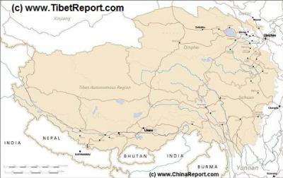
MapTibetHistoricalBorders
A Schematic Map of Historical Tibet, today Tibet Autonomous Region, Qinghai Province and a part of Sichuan province.
Included for reference are current International Borders, provincial borders, locations and names of main cities and towns, main rivers and lakes, mountains,importantTibetan-BuddhistMonasteries and other places of significance.
Further Reports link to More Photos and History & Backgrounds of each City, Town or Ethnic Community of Yugur, Dongxiang Tibetan, Lhoba, Kazakh, Mongol or others where available.
Today Tibet only exists as Tibet Autonomous Region of China. Tourist visits require an aditional visa !
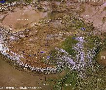
Tibet-TibetanPlateaux-SatelliteImageOverview 1A
A SatelliteImage overview Map of the entireTibetanPlateaux including parts of bordering regions of Xinjiang-UyghurAR, Gansu Province, NingxiaHuiAR, Inner-MongoliaAR,Sichuan Province,andYunnan Province. Surrounding nations and Territories are: Myanmar (Burma), Bhutan, Sikkim, Nepal, Bangladesh, India, Kashmir and Pakistan.
This Map clearly defines Provinces and Regions, main mountain ranges, main rivers & lakes of the region, locations of main cities and landmarks.
road, leading westward out of Darlag is known as the S205 Provincial Road. Yet, another road, more recently built is the S101 Provincial road. This road descends southward from Xining, the Qinghai Provincial Capital to lead over Maqen, the administrative center and military garrison center of Golog down to Darlag. Via Darlag it then curves eastward to connect with the traditionally Tibetan town of Banma (Tibetan: པདམ་རྫོ) ; Chinese: Sailaitang Town (赛来塘镇), also: Baima) in the extreme south-east corner of the Chinese created Qinghai Province.
Beyond Darlag the Yellow River enters a more mountainous region through which it curves down on its way to the border with neighboring Gansu Province. In this mountainous section only a few small villages can be found set along the river banks. Although the Google Map will show name marks of places along the river bank, none of these locations are inhabited.
After passing Ganlong (xiang) village, the river sees no houses for 10's of miles. Eventually, having received several minor tributary flows along its trajectory, the Yellow River reaches Mentang (xiang) village before crossing the provincial borders and starting its first brief pass through Gansu Province.
As mentioned above, due to the fact that the Darlag County of the Golog Region of Tibet has recently been made part of the enormous SanJiangYuan Nature Reserve, the largest such reserve area in the world, hailed by the Chinese Central
Government as the "water tower of China" no large scale developments were planned in the Darlag County and no cities, large towns or even tourists venue's or locations of interest occur in the County. However, that beings said; there is but one very significant exemption. In order to meet the demands exacted from China under the Kyoto Treaty Agreements, previous plans to build hydro-electric dams across (just about) every river on the edge of the Tibetan Plateaux which had been postponed due to "disappointing" experiences with previously built dams, have been revived. As a result, preparations for another such dam to be built across the Yellow River in Darlag County are already underway. That the preparations
violate the protected nature of the SanJiangYuan Reserve has so far been of little consequence to the Central Government. As such, already under stress from the global meltdown of glaciers, the fragile eco-system is again threatened with wholesale interruption by large scale human activities. Not to mention the effects that the further damming of the river will have on the fish population and wider eco-system in the long term. The benefits of this are apparently supposed to outweigh the loss of irreplaceable species, lifestyles and habitats.
TIBETAN SELF IMMOLATIONS - POLITICAL SUICIDES ALONG THE YELLOW RIVER:
In addition to the interesting and historical political events sparked by the entry of the Long Marchers into Tibetan territories in 1936 much more recently Darlag has also made political headlines, albeit mostly outside and China and then but briefly. Sadly, Darlag Town is the first population center found along the Yellow River which has seen a self immolation by one of the Tibetan Community members. As proven by his statements, on January 8 of 2012 a Buddhist Monk named Sonam Wangyal set himself ablaze in solidarity with what he called the Tibetan Heroes and Martyrs of the Past and in protest against Chinese rule and occupation of Tibet. As can be be found detailed written on dedicated pages across the Internet by now, Sonam Wangyal was a native of the Golog Region of Tibet. He was a much appreciated and socially very active community member, who on first appearances had many things to live for. Among things, he had created a Home for the elderly local people, and had run a school for the children of the local poor for several years. Although Sonam Wangyal was not one of the poor socially rejected, depressed alcoholics who make up the most commonly found suicide candidates among the local population, yet he chose to "sacrifice his body as an offering" (in his own words) for what he perceived as much more important and higher goal. Ever since his death in early 2012, over 100 more Tibetans have followed his example burning themselves to death in a last desperate protest against incurred and perceived injustices.
Although, today the town of Gyümai (Jimai for Chinese) is never mentioned by the Chinese Communist Party in the contect of historical relations between Tibetans and Han Chinese, as a result of the events that occured during the invasion of this part of Tibet by the Red Guerilla army in 1936 the local history of Gyümai (Darlag) should be considered most noteworthy and of great significance to the history of Sino-Tibetan Relations. That is, as described by Dick Wilson in his (Chinese suggested) account of the Long March adventure, Tibetans took pot shots at the armies along the way. Frequently, the corpses of stragglers or members of scouting units were found dead and grossly mutilated by the enemy. Coming upon Darlag - a small local war broke as the Tibetans, realising how the hungry army was about to descend alike locusts upon their meager harvest and food stocks, did everything in their power to scare the Chinese army off. Again, the Communist armies took many casulaties. As did the Tibetans (as may be assumed, there are no historical records of this).
Nevertheless, in many cases the Chinese succeeded in overwhelming the villages found and pillaging the food supply for what it was worth. As Mao Zedong would later admit (among things to Edgar Snow who wrote it down in his epic "Red Star over China") in a rare moment of honesty and oppenness, as a result the only Foreign Debt that the Chinese Communist Party had when it was established in 1949 AD, was its debt to the Tibetan People (of among things Darlag County).
Although, Mao was at the time clearly joking sarcastically and did
INDEPENDENT PEOPLES REPUBLIC OF TIBET:
Not insignificantly, although even more under-highlighted in Chinese Political History today and known by few Foreigners at any level, the Darlag County is also of great historic significance to Tibetan (political) History due to the fact that it was in these wider regions that the first ever "Republic of Tibet" was created. The first Republic of Tibet was, of course, a Socialist Peoples' Republic, and although its very existence is never mentioned by neither Tibetan or Chinese sides and thus is mostly forgotten today, it should find its rightful place in history. The main significance of the creation of the Tibetan Socialist Peoples Republic lies in the fact that was created in cooperation with the local Tibetan population, and was set up in competition with the Central Authorities by then claimed and rather ruthlessly enforced by Mao Zedong and his close-knit group of political associates within the high echelons of the Communist Party. Mao Zedong's Main Rival Zhang Guotao, more or less in direct revolutionary assault on the Leadership claims made by Mao Zedong, set up the Tibetan Peoples' Republic in an attempt to set up his own base. This Base was set up on terms much more agreeable to the Tibetan Populace than the later version, imposed by violence and threat upon all of the Tibetan Peoples, not only in Darlag, the Golog Region and Amdo Province, but in all of Tibet including its holy and sacred Capital Lhasa.
As might be expected given the later career and legacy of Mao Zedong, Zhang Guotai along with virtually his entire army were eliminated not too much later, during a botched episode of the Long March now remembered as the "Ningxia Campaign". As a result of sophisticated alterations made to the historical records regarding the period, Zhang and his army are today nearly forgotten, as is the never heard of Tibetan Peoples Republic' which only existed for a brief period. As is now known and among things very well recorded in the Book "The Long March" by Sun Shuyun, especially the revolt staged by Zhang Guotao and the malversations and sabotage instigated by Mao Zedong within the ranks of the Communist Party were an ultra-sensitive topic to the "Chairman" himself, who in subsequent years had all written records relating to the period locked inside the Communist Party Archives, never to be seen by anyone unless with special permission given by himself. Even today, long after the death of Mao Zedong all these issues are regarded as black pages in a book that officially was never written and therefor does not exist. One will not hear of it in the official Communist Party line towed on the Long March Chapter of Chinese Revolutionary history.
not show a sincere concern about the plight of the Tibetans involved, unintentionally, he thereby strongly suggested if not just outright admitted that Tibet -at the time of the Long March of 1935 and 1936, was clearly not a part of his native China. (He therefor showd that he could care less by laughing about the food taken out of the mouths of those local Foreigners. Likely, he felt that it was a minor price to pay along the way to Communist survival and ultmate victory in China).
GYUMAI - DARLAG TOWN:
The Town of Darlag itself lies on the north bank of the Yellow River, overviewing its scenery which is reportedly particularly spectacular in this section.
Although in the later summer months some adventurous souls do bicycle to the town of Darlag, most others opt to travel more safely and more comfortably.
Due to the epic of effort of Chinese road crews with massive financial backing from the Chinese Central Government Darlag's dire has isolation has been alleviated over the recent decades by the construction of several auxiliary roads, the first of which connected through the main line of communications between Xining and Lhasa, the important and strategic G214 "Qinghai-Tibet Highway". This first auxiliary