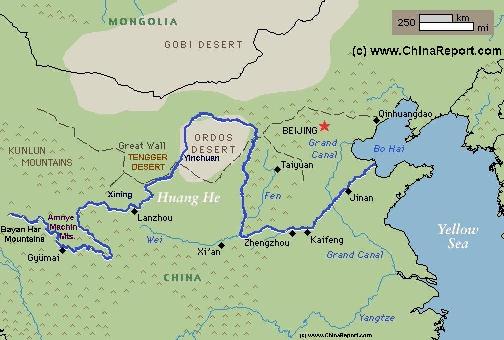
The Path of the Yellow River through Tibet & China :
Schematic Map of the Flow Path of the Yellow River through China.
Click Map to go to FULL Version !
THE YELLOW RIVER AND THE MONGOLIAN EMPIRE:
About a 1000 years after the great success of the Han Dynasty during their Rise over Asia, the Mongolian Armies united by Genghis Khan first assured their possession of an important strategic part of the Yellow River, the Ningxia Plain, before sending their armies on to their main objective, the invasion and subjection of China.
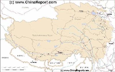
MapTibetHistoricalBorders
A Schematic Map of Historical Tibet, today Tibet Autonomous Region, Qinghai Province and a part of Sichuan province.
Included for reference are current International Borders, provincial borders, locations and names of main cities and towns, main rivers and lakes, mountains,importantTibetan-BuddhistMonasteries and other places of significance.
Further Reports link to More Photos and History & Backgrounds of each City, Town or Ethnic Community of Yugur, Dongxiang Tibetan, Lhoba, Kazakh, Mongol or others where available.
Today Tibet only exists as Tibet Autonomous Region of China. Tourist visits require an aditional visa !
THE YELLOW RIVER DURING THE WESTERN SUNRISE PERIOD:
After the slow collapse of the Tang Dynasty (618 - 907 A.D.), some regions along the upper flow of the yellow river experienced a period of flowering independence, being seperated from the rule of Central Powers out of the Chinese heartlands. With the Ningxia region, Inner-Mongolia and in Gansu Province, a new state emerged which has historically become known as that the Tangut people, in China designated as Xixia, meaning "Western Sunrise". The Tangut established their Capital within the Ningxia Plain of the
Yellow River at Yinchuan, creating their own culture as well as a small Empire situated along strategic pathways of the "Silk Road".
In 960 A.D. awith the advent of the Northern Song (Chinese: 北宋, 960–1127), Bianjing (now Kaifeng) on the Yellow River became the Capital of all China and the Dynasty controlled most of inner China.
In the year 974 A.D. Bo Ta (繁塔) a Pagoda of the Song Dynasty Era, was constructed in Kaifeng on the yellow river in Henan Province. Today it has been partially destroyed and restored since.
Chinese and other historians agree that Kaifeng was the largest city in the world from the year 1013 to 1127 A.D. ,when it was a major commercial and industrial center at the intersection of four major canals, thus creating an intersection of the economic artery of the Grand Canal. During this time, the city of Kaifeng was surrounded by three rings of city walls and probably had a population of
With the death of the Great Khan, another noteworthy plot, one that may have dramatically altered the course of history in the region by itself, also faltered.
That is, Genghis Khan had hoped to unify the Tibetans under a flag of Buddhism-Lamaism which was popular among Mongol Tribes as well, thus mobilizing the ruling Yellow Hat sect of Tibet against the Han Chinese in a military alliance. If the plan would have come together, the Mongolians might have fallen upon the Chinese Song Dynasty with the full support of the Tibetan Tribes. However, none of it was to be.
The Rulers of Tibet were inclined to respond positively to the Mongolian proposal, thus also hoping to stave off their own disaster at the hands of Genghis. However, not only did Genghis Khan himself pass away unexpectedly, so did the Tibetan Emmissary on his way from the Mountain Plateaux to the military encampment of the Great Khan. This emmissary, an important 'Lama', fell ill during the long and difficult journey, passing away at Lanzhou in 1228 AD.
In 1235 A.D. the Walled City of Lanzhou (Gansu Province) on the Yellow River fell to the advancing Mongol Armies, becoming part of the Mongolian Realm. The city was one of the last cities held by the dwindling (Jurchen) Jin Dynasty of Northern China, which had found the southern Song Allied with the Mongolians against them.
In the end, all of this was be just a stay of execution for the Chinese Song. After a temporary retreat from the front and the conquering of former north China under their new leader Ögedei Khan, the Mongolian Armies would return in even larger numbers.
The attack against the united south of China and its Song Dynasty came around the year 1270 A.D. through the route chosen by the former Khan Genghis.
Not long after their victory over the City of Lanzhou the Mongol Rulers honored the dead Lama Emmissary from Tibet by erecting a Dagoba on the highest hill-top overlooking the City of Lanzhou and named it the White Dagoba Temple. Although the original Temple on the Hill, was destroyed in history, it was rebuilt between 1450 and 1456 AD during the Ming Dynasty (1368 A.D. - 1644 A.D.), was expanded several times since and still stands today. It is the most visible and most popular historic landmark in the city offering a dramatic view of the slow passing of the yellow river below.
In 1049 A.D., the Youguosi Pagoda (佑国寺塔), or Iron Pagoda (铁塔) as it is called today was constructed in Kaifeng. The tower still stands today measuring 54.7 metres (179 ft) in height. Surviving the turmoil of wars and floods in well over 1 millenium, the Iron Pagoda has become Kaifeng's No.1 identifying landmark.
In 1050 AD, notably the third year of the reign of Emperor Huanzong of Western Xia (life: 1177 AD - 1206 AD, reign: 1193 AD - 1206 AD) the Chentian Temple and its Stone Pagoda were constructed in Yinchuan in the Middle sections of the Yellow River, then the Capital City of the Tangut (or Xixia) Kindgom.
Shortly thereafter, according to carbon dating performed on wooden beams inside the pagodas the Twin Pagoda's of Baisikou, at the time part of a huge Palace and Monastery complex, were first constructed near Gunzhongkou Village. This being in the middle to late Xixia Dynasty Period. (1038 AD - 1227 AD).
In 1127 A.D., the city of Lanzhou, the current Capital of Gansu Province was reconquered by the Han becoming part of the Jin Dynasty (1115 A.D. - 1234 A.D.) Realm that encompassed most of today's Northern China (P.R.C.). Although a vital economic win for Jin, giving it access to the Yellow River and the trading routes of the Silk Road, the city found itself in a precarious strategic situation wedged between Song Dynasty China to the South, the hordes of Tangut to the North and behind them the growing Mongolian Tide swept up by Genghis Khan.
In the year 1209 A.D. a Mongolian Army led by Genghis Khan invaded the Ningxia Plain of the Yellow River through what today is known as the Sanguankou (Three Gates Pass), a pass through the Helan Mountains south-west of today's Yinchuan City.
In 1214 A.D. Kaifeng on the Yellow River became the Capital of the fast declining Jurchen Jin Dynasty of Northern China. Although Kaifeng had already served as the Jurchen "southern capital" from 1157 A.D. onwards (other sources say 1161), the Jurchen kept their main capital further north at Beijing until the year 1214 A.D. In that year the Jin were forced to move the imperial court southwards to Kaifeng in order to flee from the Mongolian invasions of their territories. With Beijing destroyed, in 1234 A.D. Kaifeng and with it the Jin Dynasty succumbed to the combined Mongol and Song Dynasty forces. Mongols took control of North China advancing on the Song soon afterwards.
Upon the rebellion of the Tangut People (Xixia) a reinvasion occured in the year 1227 A.D.when Mongolian Armies invaded via the eastern river bank at what today is known as Shuidonggou.
The year 1227 A.D. would prove to be a crucial year along the Yellow River, as, after
YouTube Video: The Mongols and the Rise of their Empire, by History Channel.
subduing the Tangut, Genhis Khan fell ill, dying not much later in a location well south of the Yellow River, at Liupan Shan today a place situated in Guyuan Prefecture in the southernmost tip of Ningxia Hui Autonomous Region.
And so the immediate threat of a Mongolian Invasion of the Chinese Heartlands held by the remaining Song Dynasty was off for the time being while war was already ongoing in the territories of the (Jurchen) Jin Dynasty (1115 A.D. - 1234 A.D.).
In the years 1264 A.D. to 1266 A.D. Marco Polo made his first Journey into China, crossing the Yellow River at Yinchuan (Ningxia Fu) a slow flowing part of the river in the spring of 1266 A.D. and reaching Khanbalik (Beijing) shortly thereafter. This was the first ever (recorded) journey of westerners into these parts, known also as the journey of the three brothers.
Marco Polo returned from China in 1271 A.D. only to be sent on a second journey, to once more reach Khanbalik (Beijing) in 1274 A.D.
Eventually the Mongolians managed to subdue all territories from north to south, establishing the full Mongolian Rule of China (Cathay) represented by the Yuan Dynasty (1271 A.D. - 1368 A.D.). In the year 1271 A.D. Kubilai, Grandson of Genghis Khan was crowned the Emperor and Supreme Ruler.
It is believed that the Yibailingba Ta, better known as the site of the 108 dagoba's found near Xintongxia, in the western District of Wuzhong City Prefecture were built at some time during the Yuan Dynasty Era (1271 A.D. - 1368 A.D.).
Between the years 1289 A.D. and 1324 A.D. the Yellow River once again changed its course dramatically. Where the river had first flowed through Shandong Province to terminate north of the Shandong Peninsula, this time it burst its banks someway downstream from Zhengzhou in Henan Province,
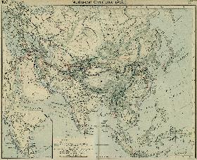
A Schematic Map of the Eurasian Trade Routes existing in the 13Th Century. Clearly marked in Red Accent on the Map are the cities of the network of land-bound trading routes through Central Asia known as the Silk Road (the path of Marco Polo and others).
Map Trade Routes in Asia in the 13Th Century.
instead of turning north flowing in a south-easterly direction into the center reaches of the Huai River which in turn emptied into the lower flows of the mighty Yangtze River.
In 1324 A.D. the situation was changed once more with the yellow river flowing more to the north again through Anhui Province and emptying into the Yellow Sea.
At some time around the year 1368 A.D., at the end of the rule of the Mongol Yuan Dynasty (1271 AD - 1368 AD), the original Mosque of Tongxin County of Wuzhong Prefecture in south-central Ningxia Hui Autonomous Region was built. Today it is the best preserved Mosque in all of western China, mostly due to it surviving the destructions of the Cultural Revolution as a Communist Party historical monument.