THE YELLOW RIVER DURING CHINA'S WARLORD ERA, THE WAR WITH JAPAN AND THE CIVIL WARS:
In 1913, the government of the new Republic of China united the garrison town of the Fortress at Hohhot in Inner-Mongolia Autonomous Region, and the small pre-dominantly Hui Community outside its North Gate, two districts, together as the town known as Guisi.
Until 1954, Hohhot would be referred to in Chinese as Guisui (歸綏)), which is the abbreviation of the two districts of the city.
In the year 1919 A.D. a passing French Archeologist staying at the mere shed of an Inn situated near the intersection of the Great Wall of China and the small Shuidong River along the desert pathway between Yanchi in the Ordos and Yinchuan on the Yellow River made an amazing initial discovery: it was a stone spearhead, which had some very unsual features.
Subsequently, in 1923 A.D. the first archeological explorations were done at Shuidonggou leading, through 6 archeological digs, to the important discovery of a stone age culture with European and Asian features. The find stands today as one of the most important stone age discoveries in China and East Asia.
The Yellow River was also a major conduit of traffic, the river itself seeing much transportation on ships and rafts when seasons allowed, the river banks seeing traffic all year around. In many places sticking roughly to the banks of the great river was the only way to avoid falling prey to the desert and keeping in
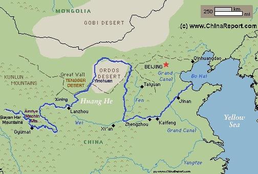
The Path of the Yellow River through Tibet & China :
Schematic Map of the Flow Path of the Yellow River through China.
Click Map to go to FULL Version !
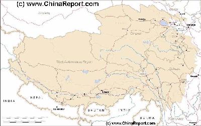
MapTibetHistoricalBorders
A Schematic Map of Historical Tibet, today Tibet Autonomous Region, Qinghai Province and a part of Sichuan province.
Included for reference are current International Borders, provincial borders, locations and names of main cities and towns, main rivers and lakes, mountains,importantTibetan-BuddhistMonasteries and other places of significance.
Further Reports link to More Photos and History & Backgrounds of each City, Town or Ethnic Community of Yugur, Dongxiang Tibetan, Lhoba, Kazakh, Mongol or others where available.
Today Tibet only exists as Tibet Autonomous Region of China. Tourist visits require an aditional visa !
In August of 1935 A.D. men and women of the renegade Chinese Communist Army, united on what has become known as "The Long March" reached the Yellow River for the first time. That is, while crossing through the marshy grasslands of Eastern Tibet roughly from south to north the two main colums of the Communists engaged the two main feeding rivers of the Yellow River. As described in several source books, the column led by General Zhang Guotai moved from Sangame a Tibetan Town in north Sichuan Province and the disputed Tibetan Border to Aba in East Tibet (Today absorbed into Sichuan Province). Once there, they found the Gequ, the white river, filled with the floodwaters from recent rains and were unable to coss it (although further political reasons have been given). Hence, the group hade to make a complete turn around and head southward again.
Near the Gequ lies the Muqu, or black river. Both rivers meet a series of large lakes along the way before confluing together forming the Maqu, the Yellow River.
In 1935 AD, Mao Zedong and the Red Army on the Long March arrived at the LuiPan Mountain scenic spot. Immediately uplifted by the beauty of his surroundings Mao Zedong famously composed a poem now known as: 'the resplendent Mount Liupan', a poem which was set to the folk-Tune of Qing Ping Yue.
Throughout 1935 AD and 1936 AD Japanese armies were
operating in Mongolia, Inner-Mongolia, Shanxi and North-Shaanxi but their armies had been defeated in a battle for the Ningxia Plain of the Yellow River and also were held up before the city of Xi'An and the yellow river in the central provinces. Mechanized units had intended to push through Xi'An in an effort to reaching Lanzhou and its oil industry but this drive never materialized. However, the Japanese air force had less trouble reaching its way west. In an effort at interdiction as well as intend to create terror, the City of Lanzhou was heavily bombed by the Japanese during the war (officially 1937 AD - 1945 AD).
In the year 1936 parts of the Communist Forces that had arrived in the so-called Ningxia-Hopei-Chahar Region to unite with the forces of the now famous Shaanxi Soviet somewhere near Mount Liupan crossed the river in a controversial operation that has become known among things as "The Ningxia Campaign".
Although files on this specific episode, a bi-chapter of the "Long March" with potentially huge political implications, remain closed what is known that parts of the Communist Party crossed the yellow river in July of 1936 A.D. with the aim of attacking Yinchuan, claiming the rich market town -mainly for resupplies, and then move via the Hexi Corridor of Gansu Province north-westward to end near the Mongolian Border and was by then de facto Russian controlled territory. 35.000 Communists, among whom the women's brigade crossed the Yellow River, the main force crossing at the ancient Yellow River harbor of Hengcheng (famous for the Shuidonggou Great Wall).
The Battle was sabotaged by political intrigues springing from a major disagreement between the two leaders of the two columns, Mao Zedong (and Zhou Enlai) on the one hand, and Zhang Guotai on the other. The entire plan to capture the city of Yinchuan failed utterly and left without communications, the 35.000 troops sent across the river embarked on a death march westward without a purpose. These troops, who by chance were under the overall command of Zhang Guotai, perished, while the remainder, led by Mao Zedong, continued their stay in Shaanxi Province, prefering to build the base and vie from power from there.
Not Long after the botched Ningxia Campaign, with the Communists still holed up and their Shaanxi Soviet, unexpected events started taking place to the South as well as to the West, all as a result of the tense political situation in China.
Having arrived earlier in the ancient Capital of Xi'An on the Wei River, Chiang Kai Shek - the "Generalissimo", was captured and taken hostage at his luxury resort, the former Tang Dynasty estate and hot springs of Huaqing at Lintung. Subsequently, the very next day on December the 13th "Tungpei Troops" (originally from Japanese held Manchuria) broke out in rebellion, taking over their station, the City of Lanzhou on the Yellow River, and refusing to further serve Chiang Kai-Shek if there was not to be a full scale war and resistance against the invading Japanese Forces in the North-East.
Although the uprising and the kidnapping of Chiang were relatively brief affairs turning the initial captor, "the Young Lieutenant" Zang Xueliang, commander in Chief of the Tungpei Armies into a captive, they made an enormous impact on Chinese Politics and actions in the following years.
Generalissimo Chiang was finally forced to actively oppose the Japanese and eventually, declare a full war. Meanwhile, the city of Lanzhou returned to relative peace, lying well out of reach of advancing Japanese Forces.
In December 1944 A.D. and January 1945 A.D. Bailie School Master and China Industrial Cooperatives official George Hogg and his band of "Children of Huangshipu" arrived on the Yellow River after walking for a month through snows and freezing rain. They had covered the 720 kilometers between Huangshipu village (today: Fengxian) in west Shaanxi Province to the city of Lanzhou, the capital of neighboring Gansu Province. It was the completion of the hardest part of their journey, which would eventually take them up the Silk Road to the county town of Shandan, near Zhangye in the Hexi Corridor, where they would be safe from Japanese harassment and the Civil War(s).
At Lanzhou, George Hogg (with help from the British Embassy and none other than Cambridge Professor Joseph Needham (a.k.a. The Man Who loved China")) rented trucks for transport to Shandan.
1947: After an official cooperation between the two main parties in China breaks down completely (as long anticipated), China once more descends into open civil war.
While the Kuomintang holds control of Central and Southern China while also retaining control of Western China (Parts of Xinjiang, the Hexi Corridor of Gansu Province, the city of Xining and today's Ningxia Hui Autonomous Region, the Communist hold sway in the country-side in northern and eastern China as well as large parts of Manchuria (developed through Soviet support).
The Kuomintang launches a military campaign to eradicate (Communist) Bandits from their home bases, bringing active civil war to the Yellow River Basin in China.
While several Foreign reporters manage to join the Communist forces in Northern Shaanxi Province (among them American Female writer and political activists Agnes Smedley) a Kuomintang Nationalist Army column led by Hu Zongnan (Chinese: 胡宗南; pinyin: Hú Zōngnán; Wade–Giles: Hu Tsung-nan; 16 May 1896 – 14 February 1962) advances on the Chinese Communist Rebel Capital of Yanan (also Yenan) in current day central Northern Shaanxi Province.
The town which has been the Capital of Communist Resistance in China since 1935 and the end of the so called "Long March" episode of the (1st) Civil War is taken in a Kuomintang Nationalist Party military offense on May 19, 1947. Although western journalists will report and through stories present the event as a heroic narrow escape of the core group of Communist Party leadership, in fact the Communists make an organized strategic withdrawal aimed at luring their old enemy General Hu Zhongnan astray from his home territory in order to fight him at a later time.
As described in several western reports (books) of the time, Mao Zedong is taken northward across the Yellow River (Huang He) in a boat, ultimately to live a mobile life on the run fleeing and fighting until the capture of Beijing in early 1949.
Regardless enormous numerical and technical superiority, ultimately the army of Hu Zhongnan was entirely unable to fight the Communist Armies, only some 20 thousand strong, led by General Peng Dehuai. The Kuomintang Forces held Yanan for about a week, then abandoning their efforts after suffering a defeat at Xihuachi due west of the city. In but a few years General Hu Zhongnan was left defeated retreating without army to Taiwan in 1950.
During the communist retreat out of Yanan as part of the "Battle of Yanan" a renowned photo of Mao Zedong sitting on a horse was made. Later this photo was (often) wrongfully attributed as being taken during the Long March, a historical event which took place over 10 years earlier.
In the aftermath of the Yanan Battle of 1947, the Chinese Communist Leadership group would live a mobile existance while civil war raged throughout North China and Manchuria. In 1949, Beijing, the former Capital fell and the Chinese Communist Leadership took up residence in the still legendary "Fragrant Hills Hotel" , a complex of luxury villa's adjacent the famous Fragrant Hills Park (Haidian District) in the western hills of Beijing near the Temple where the funeral rites for Dr Sun Yat-Sen had previously been observed. Although Communist are supposedly atheist including, as Mao Zedong underlined many times, the rejection of ancient Chinese beliefs, Feng Shui-wise it provided the perfect setting and thus spiritual and magical foundation for the start of a new Empire and a new (Feudal) Rule.
Eversince, this area of the western hills has been the reprieve of various members of the Communist Party Elite and today it is considered a posh neighborhood with abundant security and secrecy.
In the 1920's and 1930's the city of Lanzhou, Capital of Gansu Province situated on the Yellow River became a major center of Soviet Communist influence within China. It was the time of blooming Sino-Soviet Friendship with the Soviet Union being a popular model for a succesful revolution providing a brighter view than the hated capitalism driven Imperialism practiced by the European Nations and the United States. Sure enough, Tzarist Russia had been equally Imperialist, however the Russians scored some major points with their Socialist Revolution and some actions taken by its new Government since.
For one the Russians had behaved 'better' than the other Imperialist Nations that had invaded the Chinese Nation and had -among things- recently returned indemnity payments, furthermore the recent Soviet Revolution (1917 AD) in which feudalism had een replaced by a Government representative of farmers and factory workers, received great admiration from Chinese scholars, writers and politicians. While friendship flourished Lanzhou became the end-point of the 3.200 kilometers (2,000 mile) long Chinese-Soviet highway which led soviet Kazakhstan through Xinjiang (New Territories) to the Hexi Corridor and beyond to Lanzhou. The lenghty route was used to deliver Soviet supplies to Lanzhou, and from there on to the regions around Xi'an. Xi'An itself had been linked to Lanzhou by road in 1935 AD.
touch with some sort of civilization and at the very least provisions. Nevertheless, there were plenty of dangers involved in travel through the regions. As one can read in the records left by the members of the National Geographic sponsored Wulsin Expedition, the first and largest National Geographic mission into the regions, some parts were notorious for their roaming bands of bandits. While China was descending further and further into the turmoil of the warlord era, the Wulsin's passed up- and down- a substantial length of the yellow river during their lenghty expeditions through Inner-Mongolia, Ningxia and East Tibet in the year 1923. To be more exact, they arrived in China in 1921 already but did not start their lengthy expedition to the west before the spring of 1923.
After traveling by train from Beijing to Taiyuan and making their way from the end of the line through northern Shanxi Province, they arrived in Baotou for the start of the expedition itself.
The Wulsin's traveled from Baotou through the Alashan Desert of Inner-Mongolia and around the
great northern bend of the Yellow River to end up on the western side of the Helan Mountains. Making their way through the Jiucaigou Pass they then descended southward to Yinchuan, the great marketplace along the Yellow River, and eventually crossed the yellow river at Shapotou to continue down to the city of Lanzhou, at the time the location of a small community of westerners and a large Christian Missionary Church.
After recouperating and re-equiping at Lanzhou, sending off a sizeable load of scientific materials to be shipped to Harvard, the Wulsin couple eventually made its way past the Labrang Monastery also ending up at the Kumbum Monastery near Xining (today: Qinghai Province).
On the last leg of their 9 month journey, the Wulsin's descended down the yellow river from Lanzhou back to Baotou on a wooden raft topped with the American Flag.
In 1927 A.D. a massive earthquake struck the city of Wuwei in the Hexi Corridor of Gansu Province, reducing most of the local buildings and monuments to rubble. The quake also known as the Gulang Earthquake event after the location of its epicenter is estimated to have measured around 7.6 to 8.0 on the Richter Scale and was felt across the Yellow River Basin to a distance of over 700 kilometers away. Although the regions were sparsely inhabited at the time, the total death toll of the quake event stands at an estimated 49.000 souls. Reportedly, in the town of Gulang almost the only thing left standing was a 20 meter long section of the city walls and some decorated archways. All cave houses and rural dwellings in the wider regions of Gulang and Wuwei city were destroyed.
In the year 1927 A.D. the first ever Shang Dynasty (1766 B.C. - 1121 B.C.) archeological site was identified near the City of Anyang, on the Yellow River in north-east Henan Province. Excavations were started the next year in 1928 A.D., leading through an interruption by the Japanese Invasion of China and several stages to eye opening finds revealing much of the sophisticated life, culture and history of the once thought mere legendary Shang People. Among things, oracle bones, musical instruments and miraculous (ritual) bronzes were unearthed. The excavations of Shang Dynasty relics of the city of Yin at Anyang continue through to this day.
In 1928, when the Province of Ningxia of the Republic of China was formed from parts of Gansu and Inner Mongolia, Yinchuan, its largest population center on the Yellow River became the provincial capital city.
Possibly the worst flood in written history occurred in 1931 AD. Between July and November of that year, the river overflowed its banks, flooding about 88.000 square kilometers
YouTube Video: CCTV Travelogue; Special on the Shang Dynasty Capital of Anyang.
(34,000 square miles) of land completely and about 20.000 square kilometers (8,000 square miles) partially. Entire villages and huge amounts of agriculture and farmland were washed away. An estimated 80 million people were left homeless. Nearly 1 million people died in the flood itself and in the resulting famines and epidemics that resulted from the flooding another estimated one million died.
Sadly, the situation was aggravated by the military and political situation in China and the regions, leading to food speculation on a large scale. While warlords refused to supply the nessesary trains for trainsport of grain, the regions of Inner-Mongolia, Ningxia, Shanxi and to a lesser extend Shaanxi were left to suffer the full consequences.
In 1931 the Beijing to Baotou Railroad was completed, opening the first viable industrial transportation route to and from the yellow river.
1931: Kuomintang anti-bandit actions start against the Jiangxi Soviet established in the mountains of Jiangxi Province in China. It will the start of repeated campaigns against Communist strongholds in China, ultimately leading Communist Rebel Forces to embark on the "Long March".
In 1934 A.D. a German-Chinese joint-venture constructed and opened the first Baotou Airport, soon operating a weekly route connecting Baotou with Yinchuan in Ningxia and Lanzhou in Gansu Province.
One of the most creative and destructive uses of the river occurred during World War II. Chinese troops under Chiang Kai-Shek broke the levies on the Huang He in order to flood a valley and stop the advance of invading Japanese troops. The resulting flood was massive, and the death toll of the invaders topped 900,000.
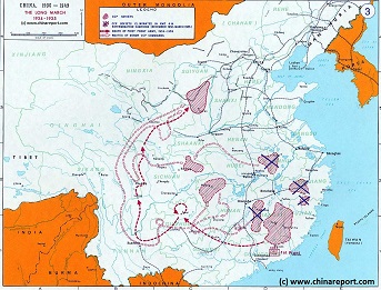
China Historic Map - Route Long March 1934/35 - 1A
A Schematic overview Map of the current Peoples Republic of China depicting the main route(s) of the epic Long March of 1934 and 1935.
Map clearly delineates PRC China current National borders and includes Provinces and Autonomous Regions, Main Cities and relevant Towns, initial Communist Soviets (Self-administered rebel areas), the routes followed by various elements among the Communist Groups and Armies, locations of important meetings points, main natural obstacles such as mountain ranges, the flow of large rivers such as the Yangtze River and Yellow River, position of the Great Wall of China in Gansu Province, Ningxia Hui Autonomous Region, North Shaanxi Province etc, rough estimated routes of main railroads of the time and other details of interest.
Mouse over locations and link through for additional information on each location.
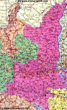
Shaanxi Province Geographic Map 1A
A Geographic overview Map of Shaanxi Province entire delineating provincial borders and parts of neighboring Gansu and NingXia Provinces in the West, Inner Mongolia Autonomous Region in the North, Shanxi and Henan Provinces to the East and Hubei, ChongQing and Sichuan Provinces in the South. This Map Includes Cities and Towns (shown by size), Main Monuments & landmarks of Shaanxi Province, the flow of the yellow river along the borders with Shaanxi- and Shanxi-Provinces, Great Wall of China locations in North Shaanxi Province, Main Mountains (with Height), major highways, provincial railroads and main railroad-stations and main waterways & rivers. This Map further provides links to on site photos and information on the City and Area of Xi'An, nearby Lintung Village and the locations of the Great Wall of China in Shaanxi Province.