History of the Yellow River (Huang He - 黃河) in the Qin and Han Dynasties
The Path of the Yellow River through Tibet & China :
ChinaReport.comat
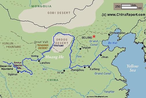
Schematic Map of the Flow Path of the Yellow River through China.
Click Map to go to FULL Version !
YELLOW RIVER DURING THE QIN DYNASTY:
The fertile Ningxia Plain of the Yellow River, located in the norther arc of the river and wedged between desert and exposed to nomadic invasions was first settled by Han Chinese during the Qin Dynasty (221 BC - 207 BC) era, around the year 220 BC. Although the first efforts at colonization of this fertile region failed during the shortlived Qin Dynasty it did lay the foundations for later success achieved during the succeeding Han Dynasty (206 B.C. - 220 A.D.).
Apart from attempts to settle the Ningxia Plain from the southern direction, during the Qin Dynasty period, Chinese farmers likewise moved upstream along the Yellow River starting irrigation works and farming efforts in the upper regions of the flow of the yellow river (as it was known at the time). It was in the Qin Dynasty that the regions of Hohhot and Baotou were first settled by Chinese, and even further upstream, near the Yang Mountains and the region currently named Linhe (County) City in
Bayan Nur League sections of the first ever version of the Great Wall of China (as recognized today) were constructed. Ruins of several Castles as well as "Purple Walls" - walls built from stone with a high iron content, which overtime have turned a purplish color - that Chinese archeologists and historians have dated to the Qin Era can still be found in these far flung regions. Other remains can be found north-west of Hohhot.
In the year 221 B.C. the King of Qin completed his conquests of all other competing States of the Warring States Period, founding the Qin Empire and proclaiming himself Qin Shi Huang (秦始皇) with his Capital at Xianyang, near prsent day Xi'An. As one of his first acts as a ruler the new "Emperor" abolished all previous state and regional borders, instead reorganizing the former Feudal Chinese Territories into 39 territories neattly divided into counties, and administered throigh a central administrative system according to a well defined sytem of Laws and Regulations. This system, with minor alterations would endure in China for some 2000 years until the fall of the Qing Dynasty in 1911 A.D. In Many forms, the borders and distinctions made in the time of the Qin Dynasty are still in force today.
In 220 B.C., the magnificent "Palace of Trust" was built on the south bank of the Wei River across from the Capital Xianyang. In the same year the Emperor decided to refurbish it and instead designate it as the "Paramount Temple also: Temple of the Polar Star" celebrating the newfound unity of the Qin Nation. It would be a contemporary of many other disappeared palaces and the fore-runner of even great architectural achievements.
The "Great Burning of the Books", ordered by the Emperor of Qin took place in the year 213 B.C. in the
But, that was clearly not enough. No Chinese army could pacify all of the endless Central Asian grasslands and thus border regions remained what they were before, vulnerable regions yet to be developed and solidified into the Han Realm.
Roaming and moving nomadic tribes were always a concern and in subsequent years the Han would to resort to an old and tried method, the construction of yet another defensive wall.
Not much can be said about the Great Wall of the Han Dynasty, except that its best preserved remains can be found in the west of Gansu Province near Dunhuang, which is far away from the Yellow River.
Although the Han had taken the Ordos and included the Yellow River into their realm building great defensive works to hold the territory it was all only temporary.
After the degradation and then total collapse of the Han Dynasty in China, the next 1000 years and beyond the great Yellow River would in fact remain a border river. It was the border between the semi-nomadic and nomadic peoples of the North and the sedentary people of the South, meaning the Han Chinese and those peoples absorbed as minorities.
YouTube Video: Backgrounds on the history of the Han Dynasty, the Great Wall and the 1000 years conflict with the nomadic neighboring peoples of the North.
The Han may have won a few battles and established themselves in the Ordos Region for the time being. In reality, the lands were difficult to hold and thus, whenever Chinese central powers failed, border regions lay open vulnerable to attack. The tide would sweep back and forth from north to south and back again over the following centuries. There was no permanent solution to the ongoing conflict between lifestyles and peoples and both sides would achieve success in their various periods.
In 176 B.C. Xiong Nu Tribes who have been driven from the Ordos Region and Ningxia Plain flock into today's Gansu Province, a former Qing Territory and Western Mongolia. Other peoples, the Yu Zhi are in turn displaced westwards.
In 138 B.C., seeking alliance against the Xiong Nu, Han Emperor Wu Di (The Martial Emperor) sends out an envoy to cross the yellow river and traverse the Hexi Corridor of (current) Gansu Province to reach out into Central Asia. Through various adventures the envoy, Zhang Qian, would be the first Chinese Man to explore the regions, forging new allainces and bringing home a body of knowledge that would help to unlock the trading paths that would ultimately become known as "the Silk Road" with its main crossing point of the Yellow River at Lanzhou.
In 133 B.C. Han Dynasty Armies led by General Wei Qing began series of military offensives northwards slowly driving the Xiong-Nu backwards and eventually across the Yellow River (in today's Inner Mongolia Autonomous Region).
In 130 B.C. the 130 kilometer long Shaanxi-to-Henan Canal was completed well south of the Yellow River. It was major feat of engineering that would lead to new heights.
In 121 B.C. Han Armies led by General He Chun Bang crossed the Yellow River into what today is Gansu Province and former Qin territory attacking and defeating the Western Xiong-Nu at a place known as He Si. The victory and conquest of the Hexi Corridor would open the way west into Central Asia. During the rest of the Han Dynasty another "Great Wall of China" is built, with fire beacons reaching as far West as the Lop Nor Desert beyond Dunhuang, in Western Gansu Province.
A Major flooding in AD 11 is said to have been a major contributing factor to the downfall of the short-lived Xin Dynasty (9 A.D. - 23 A.D.), itself an interruption of the Han Dynasty Era (207 B.C. - 220 A.D.).
Around the year 25 A.D. construction starts on the Han Guangwu Emperor State Tomb, located in the Baihe countryside of Mengjin County, about 20 km northeast of Luoyang in west Henan Province. The Guangwu Emperor is the first Emperor of the restored Han Dynasty ruling from 25 A.D. to his death in 57 A.D. and his Tomb will be the first Royal Tomb of the total of Five Tombs of the Eastern Han Dynasty (23 A.D. - 220 A.D) found near Luoyang.
The Eastern Han Dynasty Period was a brief period of re-strenghtening of Central Powers within China, a period in which the Yellow River once again stood central in the Chinese Way of Life. Some territories lossed previously during the inner strife most graphically illustrated by the brief emergence of the Xin Dynasty (9 A.D. - 23 A.D.) were reconquered by advancing Chinese Armies.
Regardless, in 220 A.D. the Han Dynasty ended, leaving the nation in turmoil.
was founded in Luoyang, the Capital of Eastern Han. Today, although much changed overtime, the temple still exists and is one of the most popular and attractive tourist attractions of the city.
The Temple is mostly noted for its early contacts with Japan and its involvement in spreading Buddhism there, as well as for its noted students and priests. Among them, An Shigao who was one of the first monks to popularize Buddhism in Luoyang and further the later Grand Master, the Tang Dynasty Era (618 A.D. - 907 A.D.)Monk Xuanzang who spent some of his early years as a lay monk at the White Horse Temple.
In the year 70 A.D. a disastrous flooding caused by deforestation in the upper reaches and excessive damming along the middle and lower reaches returned the river to its original course, as before the year 602 B.C., which is north of the Shandong Peninsula.
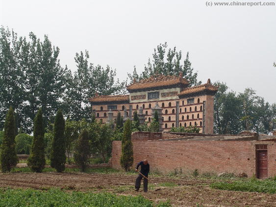
A Farmer tiling the fertile soil of the Luo He valley at the White Horse Temple (Bai ma Si), first ever Buddhist Temple in China just outside of Luoyang, Henan Province.
In the year 166 A.D., the first ever Roman envoy(s) reached China and their main goal, the city of Luoyang, Capital of the Eastern Han Dynasty, along the Yellow River. As Chinese court documents record this earliest succesful diplomatic mission was sent by "the king of Da Qin (Da Qin= the Chinese designation for the Roman Empire of whom they had known for quite some time through the exchanges of the Silk Road), Andun (=Marcus Aurelius Antoninus)", who reigned from 161 A.D. to 180 A.D. as the Roman Emperor. It was the first time that the East and West connected.
The Romans had traveled from the Persian Coast via the Indian Ocean to initally arrive in Rinan Commandery in what is now central Vietnam.
On 24 September of the year 189 A.D. the Eastern Han Dynasty Capital of Luoyang in Henan Province was sacked and burned by rebels leading to a 30 year period of unrest and instability that would ultimately lead to the end of the Han Dynasty (207 B.C. - 220 A.D.).
In the succeeding period territories previously held by the Han Dynasty north of the Yellow River, fell away emerging a short while later as the 16 Kingdoms (of the North). At the same time, in the south focussed on the Yangtze River, there were the 3 Kingdoms which gave their name to this period of history: the Three Kingdoms Period (220 A.D. - 280 A.D.).
While the South was mainly engaged with itself, the northern kingdoms were then subsequently overrun by the ever present nomadic tribes of the North leading eventually to the establishment of the Tuoba-Wei (拓拔魏) or the Northern Wei Dynasty (386
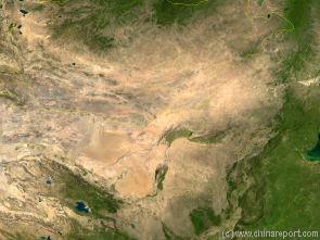
China Report - Map of the Gobi Desert & Yellow River Flow
A Satellite Image Map of the Entire Gobi Desert Region. Map overviews North-West Xinjiang Autonomous Region, Mongolia, Inner Mongolia and North and North-Eastern China giving a Full Overview of the Gobi Deserts. Clearly visible details of geographical features such as mountain ranges, rivers, valleys and lakes.
Map includes country borders, name and location details of Cities and Villages (clearly visible).
Mouse over Image to Reveal more information and follow the flow and path of the yellow river from Xining in Qinghai Province to the Bohai Sea. Details of old / former Yellow River flow (south of new) and new trajectory to the Bohai Sea.
A.D. - 534 A.D.) who by the way were by no means barbarians.
In this period "foreign" peoples came to rule over what today are the territories of Inner Mongolia, north Shanxi Province and Hebei Province, completely reverting the work and territorial expansions of the Han Dynasty. During the Northern Wei Dynasty period large parts of the upper curve of the yellow river were "hostile territory" to the Chinese, and during several large scale attacks the city of Luoyang, the first Capital of Eastern Han had been sacked and for a large part reduced to ashes. Later the 2nd Eastern Han Capital of Chang'An (present day Xi'An) suffered a similar fate leading to final loss of all Chinese control over northern regions and the Yellow River.
Meanwhile, the torch of Chinese Culture was taken over by the South, with the national Capital ending up for the first time in Nanjing, on the lower reaches of the Yangtze River in Jiangsu Province.
Yinchuan
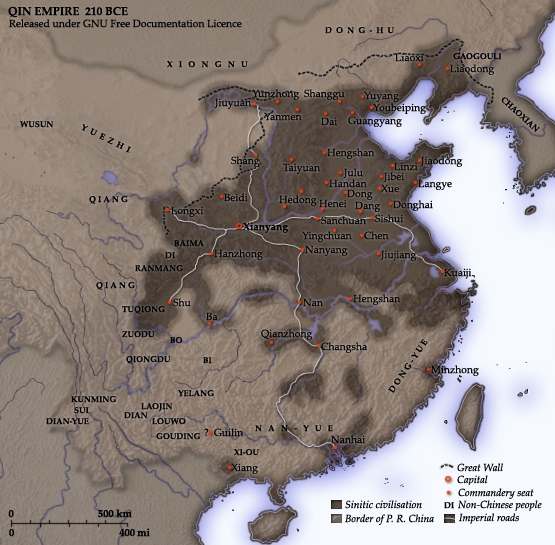
Overview Map of the Qin Dynasty Empire that would become known as China. At its very highpoint the Qin realm extended upstream along the Yellow River in Inner-Mongolia where parts of its Great Wall can be found. The Ningxia Plain was 1st settled and the main body of China from Gansu to the Liaodong Peninsula was protected by the Great Wall of Qin.
new Empire focussed on the Yellow River. Hundreds of Scholars and Intellectuals who had been opposing the new way of doing things enforced by the new Emperor where executed.
In the subsequent year 212 B.C. the Qin Emperor was equally busy, this time expanding the road system which he had ordered constructed across his united realm, as well as building huge Palaces on the south bank of the Wei River across from the Capital Xianyang. After a road system had been established with roads radiating out from the Capital (See Map), the new project involved the building of a special road to lead up north from the Capital Xianyang (Xi'An) to the bend of the Yellow River. Its construction, overseen by the legendary General Meng, was a unprecedented feat, connecting Chinese Heartlands with the "border" and the restive nomadic tribes to the North of it. The new road not only allowed for speedy supplies and reinforcements of the border regions, it also allowed for trade and enhanced contacts with- and knowledge of the nomadic peoples.
Having established the necessary infra-structure, subsequently the troops, convicts and slave-laborers under command of General Meng could embark on their construction of the first ever "Great Wall of China", most of which was situated south of the Yellow River.
and across of it along the South Bank of the River Wei. Nothing much remains of this Pleasure Garden, known from sparse records as the "supreme Garden" but it is hailed as an early model from which the enduring culture of Chinese Gardening was built. The new garden and its Palaces were connected to the city by means of bridge built across the Wei River.
Unprecedented and historically more significant was the construction of the so-called "Hipped Roof Palace", which as far as we know is supposed to have been the largest Palace ever built in Chinese History. Although today archeological excavations are incomplete, so far it has been shown that it was a two story building which may have measured as much as 1350 meters by 400 meters. Considering that the largest Hall in the Ming Era (1368 A.D. - 1644 A.D.) Palace Museum, the Hall of Preserving Harmony (TaiHe Dian), measures a mere 30 meters by 60 meters, the "Hipped Roof Hall (or Palace) must have been a gargantuous structure able to accomodate an unprecented number of people, presumably state guests.
According to various sources, the Great Wall of China of the
THE YELLOW RIVER DURING THE HAN DYNASTY:
As already mentioned, the first complete and succesful settlement of the Ningxia Plain was achieved during the Han Dynasty (206 BC - 221 AD) period leading to it being included into the Han Chinese Realm for the first time, emerging as as a 'Border Province'. In the same period the county town of Yanchi in the easternmost tip of Ningxia was established as such.
The earliest surviving mention and use of the name "Yellow River" (黃河) is in the Book of Han (Chinese: 漢書; pinyin: Hàn Shū) written in the Western Han Dynasty (206 B.C. – 9 A.D.). Records from the Han Dynasty also left the first written memory of a major shift in the flow of the Yellow River happening in the year 11 A.D. No name can be given to the place or location where this occurred.
Continuing to build their strength regardless of Han Campaigns, the Xiong Nu of the North launch an invasion further southward capturing much of today's Shanxi and Shaanxi Provinces and advancing on the Eastern Han Dynasty Capital at Luoyang in Henan Province, just south of the Yellow River. Although threatened for some time the city of Luoyang is not taken. The succesful Xiong-Nu invasion deeply disturbes the Chinese, eventually leading to a reversal of strategy.
As it is now known through various historic records, some excavated from tombs, during the Han Dynasty reign of Emperor Wu Di (141 B.C. - 87 B.C) a huge "army" of soldiers-settlers was sent northward to occupy, hold and develop much of the Ningxia Plain as well as territories along the upper bend of the Yellow River within what is today part of Inner Mongolia Autonomous Region.
According to some historians today more than two million were sent, more than the entire estimated population of the northern pasture lands together. Thus, invading in massive numbers, and helped by new inventions such as the waterwheel and later the water-mill, and employing grand schemes for land irrigation such as the building of canals, they managed to hold on to the land.
YouTube Video: "The First Emperor, the Man who made China". Dramatization of the Rule and Achievements of Emperor Qin.
Qin Dynasty if it ever existed was completed in the year 210 B.C., which also happens to be the year the great Emperor died.
Historical maps remaining from the Ch'In (Qin) Dynasty indicate that at the Time the lower flow of the Yellow River in the North China Plain lay considerably north of its present course. During the Qin and Han Era's the river passed Luoyang (in Henan Province) from where it flowed due North-Eastward along the border between Shanxi and Henan provinces, continuing due East along the border between current day Hebei Province and Shandong Province before emptying into Bohai Bay near present-day Tianjin
(today smaller rivers still occupy the former flowbed in this region).
In 207 B.C. the Qin Empire disintegrates while the State of Han, once subdued by Qing is revived. While chaos ensues across the former Qin realm the ruler of Han, one Liu Bang becomes one of the main contestors for the Throne. In the year 206 B.C. Liu Bang defeated his main rival Xiang Yu, becoming the most powerful ruler in China while, making use of the situation, Xiong Nu Forces invade the northern parts of the Qin Realm along the Yellow River in Inner-Mongolia taking major border area's away from the emerging Han Empire of Liu Bang. After his victory in the Chinese War Liu Bang is crowned as Emperor Gao Zu (高祖 ; Reign: 202 B.C. - 195 B.C.).
In 201 B.C. the Xiong Nu forces led by Mo Du once more defeated the Han Armies near the Yellow River, forcing Emperor Gaozu into major concessions. For the time being, the pasture lands along the Yellow River in Inner-Mongolia were ceeded to the Xiong-Nu while the Chinese Court attempted to solidify the peace by arranging marriages between Xiong Nu "Noblemen" and Chinese Princesses.
Regardless the sacrifices made, especially by the Princesses, the peace would be broken soon.
Meanwhile, also in 212 B.C., Grand Palaces and one of the earliest known Chinese Pleasure Gardens were constructed and installed in the Capital Xianyang (Xi'An)