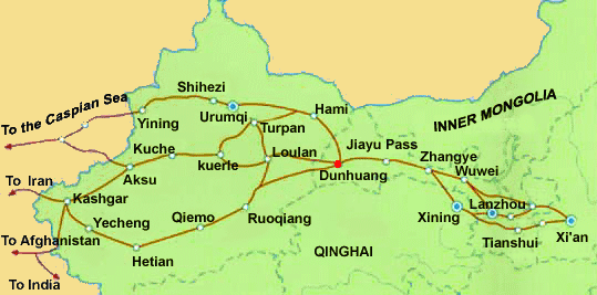
Schematic Map of the many sub-pathways of the Silk Road in China clearly showing the one-unavoidable pathway of the Hexi Corridor.
Qilian Mt Range
Mazong
Mt Range
Taklamakan Desert
Qinghai Plateux
Gobi Desert
Gobi Desert
Tibetan Plateux
Tian Shan
Mt Range
In 1226 AD, during the Last Campaign of the Greatest Conqueror in human history Genghis Khan, the City of Khara-koto was finally conquered by Mongolian Armies. Although Genghis Khan died soon after, the defeat ended the Tangut Kingdom and left the Tanguts included into the rapidly expanding Mongol Empire. However, the City of Khara-koto was not destroyed by the war but instead continued to thrive on its strategic location on the crossroads point connecting the Mongol Capital at Karakorum in Mongolia in The North, the City of Xanadu (also Shangdu) in Inner-Mongolia to the East and the Silk Road Oasis Kumul (Hami) to the West. Far from being lost in 1226 AD, the
City expanded 3 fold during the Reign of Yuan Dynasty (1271 AD - 1368 AD), a reflection of its importance as a trading City and Oasis stop-over for traders in the wider regions. Although initially the Tanguts were mistrusted by the Mongols and their ethnic group socially ostracized to some degree, the Tangut City of Khara-koto was of crucial importance to the Mongols and in the following period the Tanguts successfully integrated into the Mongol Empire. A Tangut Province was established within the Mongolian Realm, and the City of Khara-Koto continued life under its Tangut name as Edzina. In the later Era's of the Yuan Dynasty the Tanguts were accepted as equal to Mongols in rights, and many of them had a career in the Imperial Government.
Thus, the Tanguts lived on in relative peace for about a 150 years, their fortunes now firmly attached to those of their patrons, the Mongols. Thus, when the Yuan Dynasty fell the Tanguts would suffer again.
The earliest history of sizeable human inhabitation of the site of Khara-Koto likely goes back as far as the 2000 years ago. Nomadic travelers likely made use of the site and its fertile surroundings many centuries earlier.
During the reign of Emperor Wu of the Han Dynasty (206 BC- 220 AD), the Han were in strategic competition with the Xiong-Nu (also known as the Huns) nomadic tribes over control and access to the trade routes to- and resources of Central Asia. At the time the Juyan area with its lakes and wetlands functioned as the main grazing land of for the nomadic Huns in these regions. The lands became thus of vital strategic importance. After famous general Huoqubing of the Han Dynasty successfully defeated the Huns at the tender age of 19, driving them from the Juyan Lake Basin, the Han made sure to station troops there in order to deny the regions to the Mongols and defend and guard the borders.
A large number of Han Dynasty troops were stationed in the town of Ejin Qi (called Juyan in ancient times, a Chinese translation of the Mongol word for "Heaven"). As was the usual method in those Times, once at this location the soldiers built beacon towers and fortifications while also cultivating the land. A self sufficient Han Garrison was stationed in this region for quite some Time until the fall of the Dynasty in the 3rd century temporarily ended Chinese activities in the region.
With its Capital Khara-koto founded in 1032 AD, the Tangut Kingdom lay between Dunhuang in the West and parts of Ningxia Hui Autonomous Region in the East. It thrived during the 11Th Century while threats loomed on the Horizon. To the West below the Caspian Sea lay the powerful Kara-Khitan Empire with a large Army. To the South-West lay the large Chinese Empire largely controlled by the Jurchen founded Jin Dynasty with a large Army and many fortified Cities. South China was under sway of the Southern Song Dynasty. To the North and North-East arose the united Khanate of the Mongols, since 1206 AD under Leadership of Genghis Khan.
History of Khara-Koto (1032 AD - 1372 AD) :
China Report - Map of the Great Wall during the Ming Dynasty
Satellite image of China and North-East Asia, with a super-imposed schematic Map of the location and Path of the Great Wall as constructed during the Reign of the Ming Dynasty. Included for reference are City names, geographical features of landscape, Names and locations of Passes on the Great Wall of China.
The history of western Xia, or the Tangut Empire ends in the year 1372 AD, in the earliest years of the Chinese Ming Dynasty (1368 AD - 1644 AD). Having been driven out of China through a final defeat at the Jiayu Pass of Gansu Province, the Mongolian Armies of the fallen Yuan Dynasty initially retreated in haste into the Mongolian plains and wastelands. Many of the Yuan Dynasty Troops made it to Khara-Koto which was the next station North from the Jiayu Pass and most traveled through in the direction of Karakorum. However, as the Chinese Armies did not follow the Mongols further but pauzed to see the official proclamation of the Ming Dynasty in 1368 AD, the Mongols realized they had escaped, turned their horses and regrouped. While the Ming Armies were occupied returning order to the Chinese Provinces and had started renewed constructions on their Great Wall of China defenses just to the South, the Mongols gathered their strength and eyed a possible return to Rule over China. While the situation was still fluid within China, the ever agile Mongolian Armies might strike a surprise blow and regain the upperhand.
By 1372 AD Mongol Armies were massing at Khara-koto in order to use it at as a jumping off point to reinvade China through the way they came, leading to the ultimate demise of the fortified City.
Where the Chinese had halted their Armies just to the South in 1368 AD, remaining protected within the Hexi Corridor among mountain passes and away from the plains where Mongol Cavalry was superior, they did come out on to the plains in 1372 AD. In that year the amassing Mongol Armies at Khara-koto were met by a counterstrike from a powerful and
numerous Chinese Army which laid siege to the City. According to one story, recorded from local word-of-mouth by P. Kozlov, the Ming Armies could not break into the fortified city, hence they laid siege to the City. In the course of the siege the Hei River was diverted away from the City of Khara-koto by the Chinese armies leaving the City doomed. Various versions of the final demise circulate. One story holds that the Mongol General holed up inside the City committed suicide with his family, after which the army was left to await the final attack of the Chinese. Another version says that the Mongol Armies now dying of thirst made a final attempt at a break-out, only to be slaughtered alongside their ruler Buyan'temur by the Ming Armies.
Whichever way it was, the City of Khara-koto was largely destroyed by the Chinese and the majority of its inhabitants killed. Possibly, the river was indeed diverted since the Kozlov expedition did report finding evidence of a dam in in the Hei River. If this happened likely it contributed to the abandoning of the City, as the ruined environment forced survivors had to move elsewhere. Documents found at the site date no later than 1380 AD suggesting this was the latest date of inhabitation.
Afterwards the ruined city was left to be slowly reclaimed by the desert.
China Report - Map Yuan Dynasty Mongol Empire in Time 1206 AD - 1294 AD
A Schematic Map of the Mongol Empire of Genghis Khan (TeMuJin) and descendants through its several stages of conquest in its short but Impressive Existance in History. Timeline depicts the Mongol Conquest starting in the Year 1206 AD, when Genghis Khan first united the Mongol-Turkic Tribes of Mongolia and Lake BayKal becoming Great Khan. The Timeline continues through the year 1219 AD, the year 1223 AD taking Transoxiania, 1227 AD, 1237 AD when the Northern Jin Dynasty of China was annihilated, 1259 AD conquering ancient China above the Jiangste River and 1279 AD when all of China was taken and the Yuan Dynasty Established under the Kublai Khan. Last is the Year 1294 AD when the
Mongol Empire reached its largest geographical size and Zenith, 22% of world land area, but through lack of central leadership and over-expansion fragmented into 4 large parts, then imploded upon itself.
Of all these Nations, the Tangut (Western Xia) Empire seemed the weakest which led to it being chosen as the first Nation to be attacked by the Mongol Armies. Troubles started in the year 1202 AD, with further attacks by Mongols in 1207 AD.
Fear overwhelmed the Tanguts each time the
Mongol Armies threatened or advanced and in 1206 AD a power-grab brought a new King to Power in Khara-Khoto. In that year, one Li An-chuan initiated a coup d'état against Huanzong and killed him, installing himself as emperor Xianzong.
In 1207 AD a full scale invasion nearly led to the Fall of Western Xia. However, the mobile Mongol Armies of this early time had little experience with attacks on and the taking of Fortified Cities. The War ultimately ended in a draw, with the Mongol Armies leaving Tangut Territories in after their King had announced allegiance to the Mongol Throne, making him subordinate to the Great Khan Genghis. Xianzong even gave his daughter to Genghis Khan in marriage. In the aftermath of the War the Tanguts had survived but could hardly count themselves safe or blessed.
As Great Nations battled and fell around the Tangut Territories in the following years, the Tanguts found themselves in an uncomfortable alliance with the Mongols which they had only entered out of bare necessity. More Mongol attacks on the Tanguts followed in 1209/10 AD, in the years 1211 AD through 1213 AD and again in 1216 AD when the Mongols asked their allies and tributaries for military aid in their campaign to subdue the Islamic Kwarezmian Empire of Persia. Again the Tangut Court was split on what to do resulting a minor power-struggle. Angered by the lack of enthusiasm of their vassal State combined with an open challenge to Genghis Khan's authority by the Tangut Military Leadership the Mongols attacked once again and after a devastating war killed the Emperor. A new Emperor was installed and sued for Peace by 1219 AD. However, by 1225 AD new troubles arose and both Nations once more went to war.
Map Trade Routes in Asia in the 13Th Century.
A Schematic Map of the Eurasian Trade Routes existing in the 13Th Century. Clearly marked in Red Accent on the Map are the cities of the network of land-bound trading routes through Central Asia known as the Silk Road (the path of Marco Polo and others).
As mentioned the City of Khara-Koto was visited by Marco Polo around the year 1270 AD, some time after the Mongol Armies had conquered both the Northern Jin Dynasty and the Southern Song Dynasty of southern China, thereby becoming the Rulers of the Chinese Yuan Dynasty (1209 AD - 1368 AD).
Marco Polo had entered China from the West via Kashgar and Dunhuang. From Dunhuang, the journey went to Jiuquan, after which they Party stayed over for about a year in the City of Zhangye. Seemingly illogical, the traveling Party then returned to Jiuquan to travel North to Khara-Koto.
It seems likely now that after making contact with the Chinese Bureaucratic system at Jiuquan Marco Polo and his official diplomatic party were allowed to travel on to Zhangye -at the Time the Capital of Gansu Province- where they remained awaiting an official invitation to the Court of the Great Khan and Emperor, now living in Dadu (Beijing during the Yuan Dynasty).
Although the mentioning of Khara-koto in Marco Polo's travel accounts does confirm the important fact of the cities' survival after its Fall in 1226 AD during the establishment of the Mongol Empire, in all honesty Marco Polo only mentions little else of the Town. In his own (translated) words:
"When the traveler leaves this city of Ganzhou (see: Jiuquan), he rides for twelve days until he reaches a city called Edzina (identified as Khara-Koto), which lies on the northern edge of the desert of sand. This is still in the
province of Tangut. The inhabitants are idolators. They have camels and cattle in plenty. The country breeds lanner and saker falcons, and very good ones. The people live by agriculture and stock-rearing; they are not traders".
Although it could be doubted if the people of Khara-koto were traders or not, the basics of Marco Polo's descriptions still hold truth today. Now, over 800 years later, travel to Khara-koto is still easiest from Jiuquan (former: Ganzhou) in Gansu, from where it is over 400 kilometers through a sandy desert to reach Khara-Koto. In Marco Polo's days the journey would lead along the banks of the Hei River (Ejin Gol), ensuring drinking water during the 12 day treck through the Badain Jaran Desert to Khara-Koto. Still, it was a dangerous and perilous journey as inexperienced travelers could easily get lost among the sand dunes.
Today the Hei River has mostly fallen dry and the wetlands of its delta which surrounded Khara-Koto have mostly disappeared and turned into salt crusted desert. Spectacular sand dunes travel on the wind, expanding in all four directions making navigation difficult and travel dangerous if it weren't for the modern car and recently built toll roads in this huge empty region.
For centuries the so called Juyan Basin in which Khara-koto lies was a large green oasis area between various deserts and mountain ranges. Only in the last 30 years water shortages and climatic changes have made such an impact that villages and agriculture in the region has been largely abandoned. As time progresses more and more rural villages are abondoned and turn into Ghost Towns.