History of Qian 'An County of Tangshan Prefecture :
Qian 'An County of Tangshan Prefecture Climate & Weather :
Tangshan Basic Knowledge :
This page was last updated on: May 14, 2017
The Tangshan Report
Introduction to Qian 'An County of Tangshan Pref.
Qian 'An & County Landmarks & Monuments
Tangshan & Area Maps
Location : Unknown
Elevation : Unknown.
Surface Area:
Qian 'An County of Tangshan Prefecture - 1208 Sq Kilometers (-- square miles)
Urban - ..... km2 (--.-- sq miles)
Population: The Total Population of Qian 'An County and County was counted as 720,000 persons (by the end of 2010) in over 19 Towns and villages.
The China Report
The Tangshan Report is part of the overall website www.ChinaReport.com & www.drben.net
Learn about what is new on this Site from below window.
ChinaReport.comat
There are few historic landmarks in the City of Tangshan, due to the devastating Earthquake that hit the city in 1976, just before Mao Zedong′s death.
There is no information on Landmarks of Qian ′An Town. Main Roads and streets in Qian ′An County are S252 Provincial Road, Xing′an Avenue, Zhongsanyuan Street, Dasanyuan Street, Mingzhu Street, Fu′an Main Rd., Fudi Alley, Liantie North Road, Zhiyang West Road and finally Anqing Street.
The Main Monument of Qian ′An County is the Xuliukou section of the Great Wall of China which is the easternmost section of the Great Wall of China within Tangshan Prefecture of Hebei Province. The Xuliukou Great Wall of China lies due west of the Liujiakou Great Wall of China section with which it is connected. To the east of Xuliukou lies Liujiakou and the further continuation of the Great Wall into Qinglong Manchu Autonomous County (青龙满族 自治县) of the neighboring Qinhuangdao Prefecture of Hebei Province. Qinhuangdao is the easternmost prefecture of Hebei Province and the Great Wall of China continues eastward from Xuliukou via Liujiakou Great Wall to the city Pass City of Shanhaiguan (Fortress) and from there to the nearby coast at Lao Long Tou, or "Old Dragon's Head" where it ends at the Sea.
Public Transport in Tangshan
Qian ′An has a railway station but no National Level Airport.
There is no further information available on public transport in Tangshan.
There is little or no specific information available on the history of Qian 'An County. Based on finds done at no less than 7 sites within the county, earliest human inhabitation has been traced back to as early as 40 thousand years before the birth of Christ. Other archeological sites have revealed a thriving early civilization residing in the regions during the end period of the last Ice Age some 12 to 10 thousand years ago.
Ruined sites, tombs and other relics of the Shang Dynasty (1766 BC - 1121 BC (disputable), the earliest well recorded Chinese Civilization and the succeeding Bronze Age Zhou Dynasty (1121 BC - 255 BC) can be found scattered around Qian 'An County. Although a village in the county even claims to have been the place of
The seat of the local Government in Qian 'An Town is the Yongshun (永顺街道) Sub-district.
Sub Divisions that fall under the jurisdiction of Qian 'An Town include rural sub-districts near town and various townships. Besides, the Yongshun central district, there are 3 additional sub districts, which are Binhe Sub-
Qian 'An (迁安) is a county of Tangshan Prefecture in Eastern Hebei Province. Qian 'An County is situated north-east of Tianjin City and due East of Beijing City, the Capital of the Peoples Republic of China. It lies due west by north west of Qinhuangdao City, which is the easternmost City Prefecture in all of Hebei Province.
The Luan River (Luan He) flows along the western side of Qian 'An Town, limiting the growth of urban sprawl in that direction. The main river across the river in Qian 'An is the Gangcheng Road bridge. The Gangcheng Road bridge cuts across both branches of the Luan He, a winding river which curls down from the foothills of the Jundu Mountains, then splits just above the location of Qian 'An Town proper and then reunites itself into one vast flow just south west of Town.
There are no obvious landmarks or monuments in the town of Qian 'An. In the decades of the Mao Zedong Era (1949 AD - 1976) mainly an ultra-remote rural town near a generally quiet section of the Great Wall of China, and except for the longstanding mining a place without any industry to speak of, Qian 'An is mostly known for its rural history.
In the fall of 1976 the county lay at the center of one of the heaviest earthquakes in living memory, laying waste to many of its villages as well as the nearby city of Tangshan where over 250 thousand found their death. Even in Beijing buildings were damaged by the heavy quake and citizens rendered homeless.
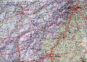
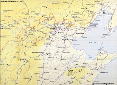
Beijing Regional Map : Datong-Beijing-ShiJiaZhuang-TaiYuan quadrangle, an overview of Beijing Municipality (in Hebei Province) and the Area to the West and South-West of Beijing. Includes Datong, Shanxi Province and nearby Pass to Inner Mongolia (Great Wall of China), BaoDing ShiJiaZhuang and TaiYuan Crossroads-cities. Wutai-Shan and Yuntong-Shan Mountain Ranges.
There is no information available on ethnic minority groups within Tangshan and City Prefecture.
Qian 'An County has a dry sub-humid (0.5 - 0.65 p/pet) climate. The land area is not cultivated, most of the natural vegetation is still intact. Except for the mountainous north, the landscape is mostly covered with buildings and man-made objects. The climate is classified as a humid continental (humid with severe dry winter, hot summer), with a cool temperate moist forest biozone . The soil in the area is high in leptosols (lp), a weakly developed shallow soil.
July is warmest month of the year with an average temperature of 29.8 °C at noon. January on the other hand, is coldest month with an average temperature of -12.6 °C at night and often bone chilling
Schematic Map depicting the multiple layers of the Great Wall of circling Beijing and North and North-East China.
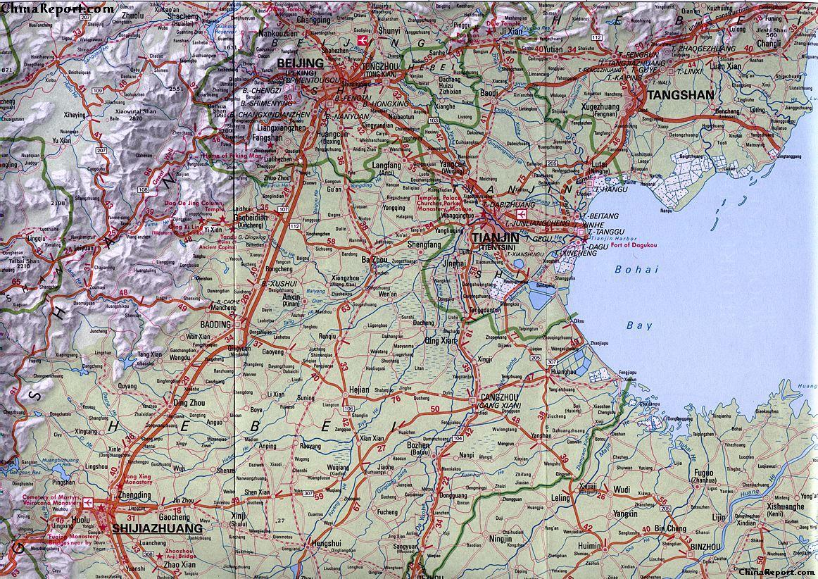
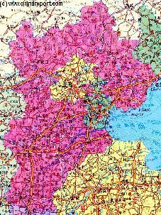
There are no maps available of Qian 'An County of Tangshan Prefecture nor specific maps of Tangshan Prefecture. There are however several Maps of the Region available at this Time.
Tangshan Hotels
There is no information available on Hotels in Qian 'An Town of Tangshan Prefecture. For most complete and accurate information check: Tangshan Prefecture Index - Hotels in Tangshan Prefecture.
Fairly well preserved over long distances and endowed with 11 ruined watchtowers (or Fortresses) and wall sections, the Xuliukou Great Wall, named as is common along the length of the Great Wall of China after the nearby village of Xuliukou, was until recently a "wild wall" section, however recently the Xuliukou Great Wall has been included into the Xuliukou Liulongquan Scenic Area, a preserved park area under Provincial and National Protection. The Park further includes a parking lot for visitors, the scenic Jiulong Pool (Jiulong Quan) and a large Forest and mountain area.
The Xuliukou Great Wall section and the village of Xuliukou find themselves under administration of Yanggezhuang Township of Qian ′An County. Quite a few villagers in Xuliukou claim ancestry to the earlier generations who have built the wall during the Ming Dynasty Era (1368 AD - 1644 AD), however one can hardly be sure if this is really the
case, Villagers along the Wall throughout China′s Provinces try to eek out extra economic benefits from the presence of the National Monument of the Wall, and quite a few have long found that a good story always helps raise sympathy. As one may find out when hiking some of the Great Wall of China without joining a commercial (or other) tour group, less friendly farmers are also known demnding your payment for right of through passage, eventhough often the road to the Monument is entirely a public road.
For more information on the Landmarks and Monuments of the Region, Please return at a later time, or browse the main index page of Tangshan Prefecture.
For a Complete Listing of Landmarks, Monuments and Hotspots in the larger Tangshan Prefecture. See: "Landmarks Monuments and Hotspots of Tangshan Prefecture".
TRAIN TRANSPORT TO AND FROM QIAN AN:
There is NO Train Station in Qian ′An Town proper. However, there is a (Jingshan Line of the) Qian ′An Railway and a station along this line due south of town just beyond the rural village of Buhuanying (Cun).
The railroad does not reach Qian ′An proper but stays on the south bank of the Luan River at safe distance from it. As a result, travelers who want to come to Qian ′An will have to prepare to get off the train at a very small rural station of Qian ′An and somehow cover the estimated 1 mile distance across the river to town via S252 Provincial Road (the main and only road to Town).
Buses and Taxi′s are available for the task if need be.
ROAD TRANSPORT IN QIAN AN COUNTY AND QIAN AN:
Qian ′An the county Town that is the center of Qian ′An County is situated at 195 kilometers due East of Beijing. Travel distance to Tianjin is 160 kilometers, to Qinhuangdao 75 kilometers and the city of Chengde, home of the Summer Palace of the Qing Dynasty (1644 AD - 1911 AD) lies at a distance of 275 kilometers from Qian ′An Town.
At this time there is only one main road in Qian ′An County, which is the S252 Provincial Road.
The S252 is a generally north- to south road. From Qian ′An southward it leads down to an intersection with the west- to east G1 Expressway and the smaller and older G102, its predecessor which runs roughly parallel to the G1 Expressway connecting the towns found along the way.
Much beyond the G1 Expressway, kilometers farther southward the S252 road intersects with G205 county road, which runs roughly west to east in this area. Eventually, after the receiving the S362 Provincial road from the west, the S252 connects down to Laoting Town, near the coast of the Bohai Sea. Laoting is a fairly pleasant rural getaway, and is the County Capital of Laoting County (乐亭县) the south-easternmost county within Tangshan Prefecture.
In the Northern direction the S252 Provincial road leads out of Qian ′An through mostly rural regions in the general direction of the Jundu Mountains and the Great Wall of China. Before meeting with the foothills S252 intersects with S363 Provincial road, another route leading west to east through Tangshan Prefecture, at a minor sized rural market town known as Jianchangying (Zhen).
In general Seismic activity in northern China is relatively high. Qian 'An and Tangshan are situated in the so called Yan Shan fold-fault zone which runs in an east-west direction through the mounntains that are found north of the Tangshan region and the town of Qian 'An.
In addition the major fault line in the regions additional minor fault lines are sitauted to the south of Qian 'An, where there are several subparallel northeast-trending fault zones (the Shanxi fault depression structural belt, the Taihang piedmont fault zone, the Cangdong fault zone, and the Tangcheng-Lijiang fault zone to be exact). Being situated at the junction of the Yan Shan fold-fault zone and the Cangdong fault zone, the Tangshan region is an especially vulnerable region within north east China (P.R.C.).
Many strong earthquakes have been recorded there over the centuries.
Since the 1966 Xingtai (425 km southwest of Tangshan) earthquake, there have been frequent earthquake events with magnitudes greater than 6. Today, Qian 'An remains heavily at risk from earthquakes with at least five quakes measuring around 5.0 on the Richter scale or higher recorded in the year 2013.
QIAN 'AN TOWN IN GENERAL:
In Qian 'An Town there are no Temples, Statues or other landmarks of interest to look for. Until at least the year 2006 it was nothing but a rural dump town that was more a blight on the landscape than a pleasurable rural place of residence. Among things, the Sanlihe, the main river flowing through the center of town was heavily polluted. That is, before it dried up entirely leaving only a gully filled with waste and toxic residues from metallurgical industries and the mines (among which the largest open pit mine in Asia) upstream.
Having undergone a thorough clean up and major structural investments, of late, the Sanli river has been revived by syphoning waters from the nearby Luan River and beaming through a designer landscape with islands of trees, lush green wetlands and modern artworks with Chinese characteristics.
Today the greenbelt thus created is a model work of cityscape creation, making the greenbelt the center of the Town as the river once was.
Other than the 13 kilometer long green beltway formed by the revived Sanlihe, the only other reprieve from the town-scape is the river Luan (Luan He) and the small Huangtaishan Park, which lies in the west section of town not too far from the banks of the River.
Due south of town of the south bank of the Luan He and across the bridge of the S252 overlooking the LuanHe. This park known as Longshan Park is a favored stop off point for those heading north- and south along the road on their way to the main landmark of the county, the Great Wall of China.
district (滨河街道), Yangzidian Sub-district (杨子店街道) and Xing′an Sub-district (兴安街道).
The 6 outlying rural towns and townships of Qian 'An County are; Malanzhuang Town (马兰庄镇), Caiyuan Town (蔡园镇), Dacuizhuang Town (大崔庄镇), Yejituo Town (野鸡坨镇), Zhaodianzi Town (赵店子镇), and finally Jianchangying Town (建昌营镇).
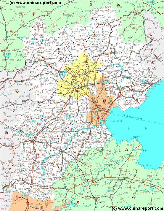
HEBEI MAP 2 :
A second topographical map of Hebei Province.
Click to go to Full Map.
Qian 'An County counts around 66.8 million acres of Forest Area, most of it found in the mountainous northern territories within the county. Reportedly, through an effort at reforestation, Forest coverage reached a total of 40% in recent years.
Among the main geographical features of the flatlands found in Qian 'An County are the Luan River and two water reservoirs.
The Luanhe is a large river which flows from the Great Wall of China and the Daheiting Reservoir in Zunhua County into the north west corner of Qian 'An County. Initially flowing due eastward, the river makes a sharp turn southward due north west of Qian 'An Town before winding its way southward and turning east to met the Bohai Bay of the Yellow Sea.
The first of the water reservoirs is the Fangguanying Reservoir which is found several kilometers due north west of town and is separated from it by (in order of appearance) the Luan River, various agricultural villages, a massive but (as yet) unidentified drainage canal (which turns a river in spring time and in the rainy July-August season), a railway line and a number of hills.
The second, slightly smaller Shigang (Water) Reservoir which is situated several kilometers due west of town.
The other obvious other feature are the mountains which rise in the northern parts of
Qian 'An County and which are the location of one of the main historic attractions of the county and larger Nation, which is of course the Great Wall of China.
The northern regions of Qian 'An County are also the location of various coal, iron and gold mines. Among these mines is the largest open pit mine in Asia entire, a scar on the landscape which can be found near Malanzhuang, due north west of Qian 'An Town.
Altogether there are no less than 4 identified sections of the Great Wall in Qian 'An County, the most prominent and most well-known today are the Xuliukou Great Wall section and the Baiyangyu Great Wall section. To be more precise, the Xuliukou Great Wall section is the easternmost section found in Qian 'An County. It connects further eastward into Qinhuangdao Prefecture.
In the western direction the Xuliukou Great Wall connects to Lenkou Guan, another minor pass city and miles long section of the Great Wall of China. The next section of the Great Wall of China is then Heliukou, and finally the last wall section in Qian 'An County is Baiyangyu, which is also the most well visited and most developed part of the Great Wall in this county of Tangshan Prefecture. As one might have expected, the Baiyangyu Great Wall Section is found near Baiyangyu Village (=Cun), an insignificant set of buildings just a short throw north of the S363 Provincial Road which cuts west to east through the northern parts of Qian 'An County just underneath the foothills and mountains that contain the Great Wall of China. A narrow road along an unidentified river leads northward and upstream from S363 Provincial Road to Baiyangyu Cun from where one can makes ones way to the Baiyangyu Great Wall Scenic Area or not.
In the opposite, western direction the Great Wall continues ruined and damaged but nearly unbroken for many miles westward.
China Report - Map of the Great Wall during the Ming Dynasty
Satellite image of China and North-East Asia, with a super-imposed schematic Map of the location and Path of the Great Wall as constructed during the Reign of the Ming Dynasty. Included for reference are City names, geographical features of landscape, Names and locations of Passes on the Great Wall of China.
Daily life and the economy in Qian'an County are still very much traditional in the sense that they are closely tied to local agriculture.
Qian 'An is situated in the so called Beijing - Tianjin - Tangshan- Qingcheng Metropolitan area, regarded as an important economical zone in north-eastern China. In regards to the economic development plans for this zone major highways have been constructed. The most relevant of the highways is the Beijing-Qinhuangdao Expressway designated G1, which passes through the southern parts of Qian 'An County, providing easy road access to the outside world. For economic relevance it may be noted that this road continues beyond Qinghuangdao to lead up the Coast to the Shenyang (formerly: Mukden), the former Manchu Capital
residence of the very first Chinese Emperor, known as the Yellow Emperor
(For more information, see: "Introduction to Chinese History - Summary 5000 years & Chinese Dynasties"), one might take such claims with a grain of salt. Although the legend of the Yellow Emperor may yet emerge from the mysts of time, so far no evidence of his true existence have ever been found.
As can be read in the full history of Tangshan Prefecture and the histories of neighboring counties and their sections of the Great Wall of China until as late as the turn into the 20th Century and the subsequent fall of the Manchu led Qing Dynasty (1644 AD - 1911 AD) all of Tangshan Prefecture was mostly counted as remote rural territory, lands where remote farming villages and their inhabitants led a relatively secluded life with little contact with the regional cities let alone the outside world.
As an illustration of this fact one may remember that the mining industry, which took some importance in the 2th century development of North Eastern China, only arrived in 1877 AD and that due to the resulting economic development of the region the city of Tangshan itself emerged. Previously, at least until the Guangxu Emperor appointed Tangshan as the location for the opening of coal and ore mines in the mountains in the north of what today is Tangshan Prefecture in 1887 AD, Tangshan had only been a rural town itself. Much later, only as late as in 1938 AD, Tangshan was of sufficient size and importance to be administratively recognized as City. From then on Tangshan was mostly known as a mining and agricultural district which it remained until the devastating earthquake of 1976 which rattled the City and rural towns in the vicinity.
(NO specific earthquake damage for Qian 'An Town or County in 1976 can be reported at this time, however his topic is under investigation).
Possibly as a result of its small size and remote rural background virtually no persons of historical interest or importance are known to have been born and raised in the town of Qian 'An or any of its Townships.
The only widely known such person is a man named Yang Xiufeng.
READ MORE ABOUT THE HISTORY OF QIAN 'AN & COUNTY IN:
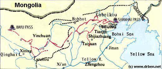
Map - Schematic - Hebei-Beijing-Tianjin Great Wall Locations
A Schematic Map overview of Great Wall locations and sections in Shanxi Province, Hebei Province, Beijing City Province, Tianjin City Province and parts of Liaoning Province. This Schematic Map focusses on the seperate visitable Great Wall of China locations and sections within the depicted regions, and includes as the Main Monuments and Scenic Sites in their vicinity as well. Find the locations of the Great Wall of China in northern Shanxi, the famous fortified "Heaven's Gate" (Kalgan) Fortress in northern Hebei Province, the "First Gate under Heaven in the East and the Terminus of the Inner Layer in the East (Laolongtou) and several often overlooked sites in Liaoning Province.
now turned industrial hub and logistics center in Manchuria.
Significantly, with the G1 Expressway having replaced the older S102 Provincial Road Qian 'An and other towns along the route have far better road connections with surrounding cities, ports and airports. An interesting side-effect has been a boost to the tourist industry along the sections of the Great Wall of China in Qian 'An County, as tourist have likewise gained better access to the previously remote agricultural county of Qian 'An.
Qian 'An has proven deposits of Iron Ore in the amount of 2.7 Billion tons. Apart from various sorts of Iron Ore, the county is also rich in magnesium, copper and gold. As a result, the county is not only home to considerable natural beauties and the historic Great Wall, but also to the blight on the landscape, represented by the largest open pit mine in Asia entire, which -in size as well as production- surpasses the renowned and strategically important Musan Iron Mines of Musan in North Hamgyong Province of North Korea (D.P.R.K.). Centered upon the Malanzhuang Open Pit Mine (马兰庄铁矿), which is situated due north west of Qian 'An Town, the Iron Industry, one of the backbone industries of northern China, has increased its presence in the county as have assocciated metalurgical industries. The County currently ranks at No. 11 in the list of Iron Producing territories in the world. The resulting airpollution and ecological destruction is noticable through the north east.
MALANZHUANG IRON MINE:
Located in a Hilly Area near Malanzhuang Town of Qian 'An County, the Malanzhuang Open Pit Mine lies at a height of around 73 meters (239.5 ft), which is considerably lower than the mountains through which the Great Wall of China runs. Minerals mined at Malanzhuang include: Albite, Amphibole Supergroup,
Opened in the year 1991 the Malanzhuang Open Pit Mine is still expanding today. Recently, the combined Tangshan (Prefecture) Iron Mining and Steel Industries added another 940,000 tons of cpacity for Iron Ore delivery to what is in effect, the largest steel producing region on the planet today.
The mine is operated by the Tangshan Malanzhuang Iron Mine of Capital Iron and Steel Co. Locally, associated Steel Industries are known as the Shougang Iron (of) Malanzhuang (additional Iron Mines and Steel production can be found in Luannan County of Tangshan Prefecture. Altogether Hebei Province has 30 mines ).
Although such information usually goes heavily under reported within the Peoples Republic of China, by now it is clear that the presence and operations of the Malanzhuang Open Pit Mine have led to a tremendous destruction of the local landscape and heavy contamination of groundwaters and nearby rivers such as the all important Luan River. the Luanhe which flows just north of the mine and subsequently passes just west of Qian 'An City, is one of the main water source of Qian 'An County and as such its pollution has contiminated both drinking and irrigation waters, slowly poisening the people as well as agricultural lands. Other affected rivers named are the Sha River (Sha He) and Sanli River (Sanli He), both minor rivers within the county.
Notably and as is now internationally well established, open-pit mining is environmentally much more destructive, and also more polluting than underground mining activities. In addition to a total destruction of the local landscape and eco systems,there are substantial risks for a secondary geological disaster, (earthquake or lanslide), ground and surface water pollution and even atmospheric pollution through transport of toxic dust particles elsewhere. In general, any open pit mine will annihilate the lanscape and lead to heavy metal pollution.
As a result of decades of mining activity at the Malanzhuang mine, the current day Government of Hebei Province is struggling with a legacy of heavy pollution. Although notable clean up operations have succeeded among things in restoring the Sanli River in Qian 'An City Town fact remains that the regions are experiencing a record shortage in available waters, and that both ground waters and surface waters remain tainted with heavy metals and chemical toxins.
In order to fight desertification and contain toxic dust emmissions from abandoned parts of the Malanzhuang Mine, the local Government is currently experimenting with various replantation regimens, sharing its experiences with other similar sites in the world.
winds. Qian 'An County has distinct cold and warm seasons, like cold winters and warm summers. The temperatures at night are cooler than during daytime.
Winter has prolongued freezing periods, with the coldest month most often being January. January is on average the month with most sunshine. Rainfall and other precipitation peaks around July. The time around January is driest.