Yanqing County Great Wall locations :
Miyun County Great Wall locations :
Great Wall of China locations in Tianjin City Province :
List of Great Wall of China locations in Beijing City Province :
This page was last updated on: May 1, 2017
Click & Go to Gansu Province Map 2
Dawukou or Juicai Gou Great Wall of China Site
Kangning Village, Xiaoman Township Great Wall of China - Gansu-Inner Mongolia Border (Outer Layer)
Lanzhou
Xining
Guyuan
Wuwei
Zhangye
Jiuquan, Gansu Province
Guyuan Great Wall Site - Ch'In Dynasty Era Great Wall
Dingbian
Jingbian Great Wall Site
Yulin
Zhongwei
Xiahe'Yan Great Wall Site - Gansu/Ningxia Border (Inner Layer)
The China Report
Shanhai Guan/Pass
ChinaReport.com at
To Main Menu of All Websites at DrBen.Net
Go to www.drben.net webring
A Complete List of all Great Wall of China Locations & GPS coordinates :
Province & Area :
Location Name :
GPS Coordinates :
Find all known locations o/t Great Wall and Follow its Pathway from Dandong and the Yalu River at the Liaoning Province Eastern Border around Shenyang to Qinghuangdao and Shanhai Pass on the Bohai Sea Coast. Then from the Eastern Bohai Sea to Beijing, from Shanxi Province to Shaanxi Province, and then via Ningxia Hui Autonomous Region and the Gobi Desert of Inner Mongolia to wind up in Gansu Province in the far West of China, near Dunhuang at the edge of the Taklamakan Desert. Apart from this main pathway, additional sections are identified within Qinghai Province and in Inner-Mongolia AR.
Outer Defensive Layer locations, Inner Defensive Layer locations and supporting Fortresses are included in this List where possible ! Some locations may have disappeared or remain unfindable on Google Earth Maps.

The Great Wall of China was built in different historical periods. The exact length of the Great Wall of China as was constructed during the Ming Dynasty (1368 AD - 1644 AD) was determined to be 8,851.8 km in December 2008, as announced by a national survey team.
Zhangjiakou
Lop Nor
(Salt lake)
Yu Men Pass
Yinchuan, Capital of Ningxia Province
Lanzhou, Capital of Gansu Province
Beijing, Capital of China
Datong, North Shanxi province
LuoYang, Henan Province
Xi'An (Chang'An), Capital of Shaanxi province
JiaYuGuan Pass& Fortress, Gansu Province
MutianYu Great Wall Site, Gubeikou Township, Huairou District, Beijing City Province, China (PRC)
Ba Da Ling Village Great Wall of China, Changping Township, Yangqing County, Beijing City Province, China (PRC).
Extended Arm Great Wall at JiaYuGuan Pass
Han & Tang Dynasty Great Wall Sites
Yu Men - Jade Gate Pass - 1st Pass in the West (Han & Tang Dynasty)
Dunhuang, Western Gansu Province
A Schematic Map of the Several Layers of the Great Wall of China defenses as they existed during the Ming Dynasty (1368 AD - 1644 AD) in Gansu, Qinghai, Ningxia, Shaanxi, Shanxi and Hebei Provinces. Map includes location of + link to Great Wall Passes as reported on by ChinaReport.com. Mouse over & Click Links for more Information and Photos.
Yang Guan Pass - Fortress & Beacon - Start Point South Route of Silk Road to Kashgar
Yang Guan Pass
Jia Yu Guan Pass
  X
YanMen Guan Pass
Pian Guan Pass
Pian Guan Great Wall Site
Ya Men Guan Great Wall Site
Ordos Desert
TengGer Desert
Taklamakan Desert
Gobi Desert
Gobi Desert
Gobi Desert
Qinghai
Hu
Xining, Capital of Qinghai Province
TaiYuan, Capital of Shanxi province
Wei River
Yulin Great Wall Site
Dingbian Great Wall Site
Sanguankou - Helan Pass Great Wall Site
Zhongwei Great Wall Site
Yonchang Great Wall Site
Simatai Great Wall Site, -- Township, Miyin County, Beijing City Province, China (PRC)
  X
Pingxing Guan Pass
Pingxing Guan Great Wall Site
Ningwu Guan Great Wall Site
Zhangjiakou (Kalgan) Great Wall Site
Tianjin Municip. , Ji County


Tianjin Municip. , Ji County
Huangyaguan - Yellow Cliff


Taipingzhai
40°14′37.33″ North
117°26′20.32″ East

40°14′47.29″ North
117°27′19.52″ East
Beijing Municip., Pinggu,
-- Township
Jiangjungguan
40°16′60″ North
117°20′60″ East
Beijing Municip., Huairou


Beijing Municip., Huairou


Beijing Municip., Huairou,
-- Township

Beijing Municip., Huairou,
-- Township

Beijing Municip., Huairou


Beijing Municip., Huairou


Beijing Municip., Huairou


Beijing Municip., Huairou

----> Jiuyanlou (Outer Layer) continues into uncharted Chashikou to Haizikou Great (Wild) Wall
Qinglong Xia (青龙峡) / Dashuiyu Gou (大水峪关)

Hefangkou


Shentangyu


Lianhuachi


Mutianyu


Jiankou


Beijing Knot


Jiuyanlou
XX° XX′ XX″ North
XX° XX′ X″ East

40° 26′ 30″ North
116° 39′ 30″ East

Not availabe


Not available


40°26′17″ North
116°33′43″ East

40°27′20″ North
116°30′10″ East

Available soon


40° 28' 51.18" North
116° 30' 8.39" East


40° 26' 43" North
116° 28' 31" East

40° 27' 34" North
116° 27' 13" East

40° 27' 10" North
116° 26' 42" East

Not Available


40° 27' 10" North
116° 24' 23" East


40° 27' 3" North
116° 24' 23" East

40° 25' 53" North
116° 22' 37" East


40°24′52″ North
116°19′37″ East

Not Available


Not available


40° 24' 43" North
116° 18' 25" East

40° 24' 42" North
116° 18' 5" East

Not available
Longquan Guan Great Wall Site
Niangzhi Guan/Yangquan Great Wall Site
Shanhai Pass/Qinghuangdao Great Wall Site
Yanchi Great Wall Site
Beijing Municip., Yanqing, Badaling Township.


Beijing Municip., Yanqing, Badaling Township.


Beijing Municip., Yanqing, Badaling Township.


Beijing Municip., Yanqing, Badaling Township.


Beijing Municip., Yanqing County, Badaling Township.


Beijing Municip., Yanqing, Badaling Township.
Shixiaguan is the final stretch in western Beijing Province. For some miles it forms the border between Huairou District of Beijing and Zhangjiakou Prefecture of Hebei Province.
The Great Wall continues in Hebei as Jiminggou Great Wall.
Nankou


Juyongguan Fortress


Shuiguan


Qinglongqiao


Badaling


Shixiaguan
40° 13′ 35″ North
116° 6′ 47″ East


40°17′ 32.76″ North
116° 3′ 55.69″ East


40° 20′ 14″ North
116° 1′ 54″ East


40° 21′ 1″ North
116° 1′ 9″ East


40° 21′ 15.83″ North
116° 0′ 25.04″ East


Not Available
Site Map of Badaling Great Wall of China location,
some 58 Km outside Beijing proper. Car Parking, Train Station, Area and All Walkable Wall Sections included.
Guide Map to Badaling Great Wall
[ Back to Top of Page ]
Back to Top of Page !
Damaqun Shan
HuangYaGuan - Yellow Cliff Great Wall Site
Find out about the Layers & Remnants left from subsequent Era's & Dynasties !!
Ming Dynasty Era Great Wall & Locations !!
Sanguankou
Wuwei, Gansu Province
Wei River
Yellow River
Yellow River
Fen River
Fengzhen Pass Great Wall Site
Inner Mongolia, Fengzhen
Fengzhen Pass
40°43′15.96″ North
113° 16′ 71.55″ East
Zhangye, Gansu Province
Shuidongkou Great Wall Site
Kaifeng, Henan Province
Jinan, Capital of Shandong Province
My Great Web page
Google Map Quick Link


Google Map Quick ink
Google Map Quick Link


Google Map Quick Link
China Report - Map of the Great Wall during the Ming Dynasty
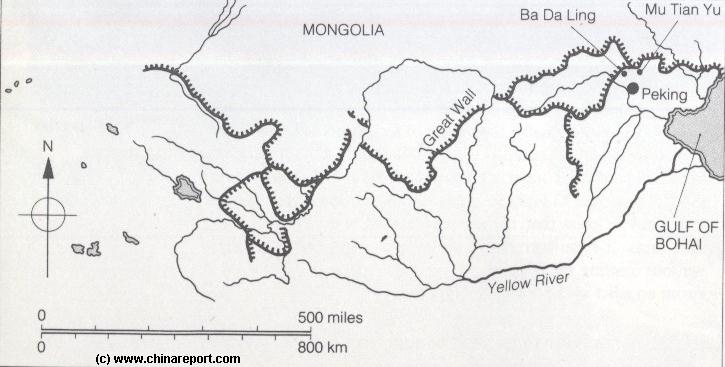
Satellite image of China and North-East Asia, with super-imposed schematic Map of the location and Path of the Great Wall as constructed during the Reign of the Ming Dynasty. Included for reference are City names, geographical features of landscape, Names and locations of Passes on the Great Wall of China.
Updated with additional Google powered GPS Map of Great Wall locations !
Click Map to View !!
China Maps
Satellite Maps
China Online Sources
China Offline Sources
China Online Store
Art & Culture
History
China News
China Travel
DrBen.Net Home
China Provinces /Home
DrBen.Net Partners
China
AsiaReport.com Home
Asia
China Report Club
Blog
Twitter
Forum
Chat
DrBen Live TV
China Video Library
China Photo Library
China Politics
Provinces Maps
City + Site Maps
Historic Maps
Travel Great Wall
GW Maps
GW Historic Walls
GW Structures
AT THIS POINT THE GREAT WALL ENTERS INTO BEIJING CITY PROVINCE AS JIANJUNGUAN WALL IN PINGU COUNTY - CLICK THROUGH >>
After passing through Beijing City Province the Great Wall re-enters Hebei Province at ... after which its heads towards Zhangjiakou a.k.a. "Kalgan" (Khaal-Gan or Mongolian for Heaven's Gate).
AT THIS POINT THE GREAT WALL ENTERS LEAVES BEIJING CITY PROVINCE. It Continues in West Hebei Province as the Jiming Gou Great Wall of Zhangjiakou Prefecture  - CLICK THROUGH >>
After passing through Beijing City Province the Great Wall re-enters Hebei Province at Jiminggou after which its heads towards the City of Zhangjiakou a.k.a. "Kalgan" (Mongolian for Heaven's Gate).
See + Browse ALL Great Wall Locations near Beijing !!
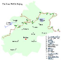
Map of Beijing City Province and ALL Locations of The Great Wall of China visitable within Beijing City Province and Immediate Vicinity.
GW Coordinates
Huairou District Great Wall locations :
Beijing Municip., Miyun


Beijing Municip., Miyun,
Dachengzi Township

Beijing Municip., Miyun,
Dachengzi Township

Beijing Municip., Miyun,
Dachengzi Township

Beijing Municip., Miyun,
--- Township

Beijing Municip., Miyun,
-- Township

Beijing Municip., Miyun,
-- Township

Beijing Municip., Miyun,
-- Township

Beijing Municip., Miyun, Gubeikou Township

Beijing Municip., Miyun, Gubeikou Township

Beijing Municip., Miyun, Gubeikou Township

Beijing Municip., Miyun, Fenjiayu Township

Beijing Municip., Miyun
Bailingguan


Dachengzi


Buzili


Anyingzhai


Qianshuihe


Wulingshan


Heiguan (Wuhu Men)


Dajiaoyu (Beiling)


Simatai


Jinshanling


Gubeikou


Fengjiayu


Beishicheng
40°40′30″ North
117°21′45″ East

XX° XX′ XX″ North
XX° XX′ X″ East

XX° XX′ XX″ North
XX° XX′ X″ East

40°24' --″ North
117°14'E --″ East

40°29' --″ North
117°16' --″ East

XX° XX′ XX″ North
XX° XX′ X″ East

40°38'51.73" North
117°29'49.80" East

XX° XX′ XX″ North
XX° XX′ X″ East

XX° XX′ XX″ North
XX° XX′ X″ East

40°41′0″ North
117°14′10″ East

40°41′20″ North
117°9′18″ East

40°37′13″ North
116°52′29″ East

XX° XX′ XX″ North
XX° XX′ X″ East
Google Map Quick Link


Google Map Quick ink
Moshikou is a Branch of the Inner Layer west of Jiankou
Beijing Municip., Huairou

Continues westward into
Beijing Municip., Huairou

Continues westward to
Beijing Municip., Huairou

Is continuous with
Beijing Municip., Huairou
and

Beijing Municip., Huairou
is continuous with Jiugongshan

Beijing Municip., Huairou

From Sanchakou to
Beijing Municip., Huairou,
-- Township

Connects to
Beijing Muncip., Huairou
connects to Xishuiyu

Beijing Muncip., Huairou

Leads north from Huanghuacheng / Xishuiyu Fork
Beijing Municip., Huairou,
-- Township

Beijing Municip., Huairou


Beijing Municip., Huairou


Beijing Municip., Huairou
Moshikou / Moyashike


Xiangshuihu


Lianyunling


Dazhenyu


Sanchakou


Tiekuangyu


Jiugongshan


Huanghuacheng


Zhuangdaokou


Erdaoguan (Branch)


Xishuiyu


Xiaoxihu


Longquanyu